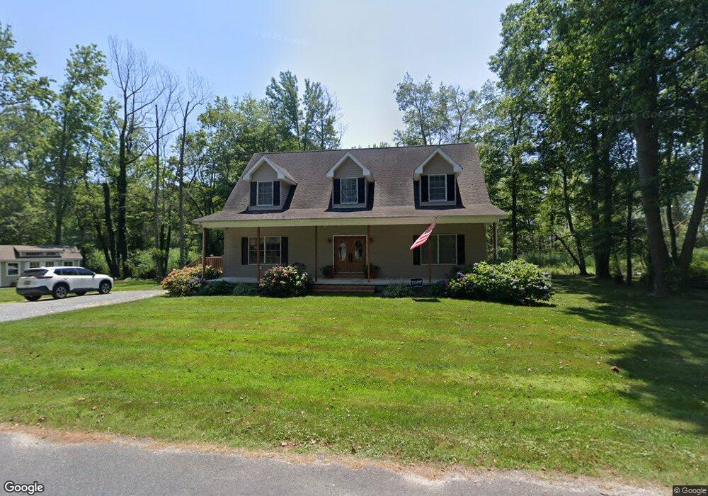
21710 Sunnyside Ave Rock Hall, MD 21661
Estimated Value: $377,000 - $435,000
3
Beds
2
Baths
1,908
Sq Ft
$217/Sq Ft
Est. Value
About This Home
This home is located at 21710 Sunnyside Ave, Rock Hall, MD 21661 and is currently estimated at $413,241, approximately $216 per square foot. 21710 Sunnyside Ave is a home located in Kent County with nearby schools including Center for Innovation, Kent County Middle School, and Kent County High School.
Ownership History
Date
Name
Owned For
Owner Type
Purchase Details
Closed on
Dec 16, 2011
Sold by
Hall Allison L and Mclean Allison L
Bought by
Hall Allison L
Current Estimated Value
Home Financials for this Owner
Home Financials are based on the most recent Mortgage that was taken out on this home.
Original Mortgage
$214,400
Outstanding Balance
$146,594
Interest Rate
4%
Mortgage Type
New Conventional
Estimated Equity
$266,647
Purchase Details
Closed on
Jun 10, 2010
Sold by
The Peoples Bank
Bought by
Mclean Allison L
Purchase Details
Closed on
Aug 6, 2008
Sold by
O'Connor Brian J
Bought by
The Peoples Bank
Purchase Details
Closed on
Aug 1, 2008
Sold by
O'Connor Brian J
Bought by
The Peoples Bank
Purchase Details
Closed on
May 20, 2004
Sold by
O'Connor Brian J
Bought by
O'Connor Brian J
Create a Home Valuation Report for This Property
The Home Valuation Report is an in-depth analysis detailing your home's value as well as a comparison with similar homes in the area
Home Values in the Area
Average Home Value in this Area
Purchase History
| Date | Buyer | Sale Price | Title Company |
|---|---|---|---|
| Hall Allison L | -- | None Available | |
| Mclean Allison L | $215,000 | -- | |
| The Peoples Bank | $334,842 | -- | |
| The Peoples Bank | $334,842 | -- | |
| O'Connor Brian J | -- | -- |
Source: Public Records
Mortgage History
| Date | Status | Borrower | Loan Amount |
|---|---|---|---|
| Open | Hall Allison L | $214,400 |
Source: Public Records
Tax History Compared to Growth
Tax History
| Year | Tax Paid | Tax Assessment Tax Assessment Total Assessment is a certain percentage of the fair market value that is determined by local assessors to be the total taxable value of land and additions on the property. | Land | Improvement |
|---|---|---|---|---|
| 2025 | $3,211 | $285,200 | $0 | $0 |
| 2024 | $3,056 | $269,500 | $65,400 | $204,100 |
| 2023 | $2,991 | $263,733 | $0 | $0 |
| 2022 | $2,900 | $257,967 | $0 | $0 |
| 2021 | $2,860 | $252,200 | $65,400 | $186,800 |
| 2020 | $2,860 | $252,200 | $65,400 | $186,800 |
| 2019 | $2,860 | $252,200 | $65,400 | $186,800 |
| 2018 | $2,862 | $252,400 | $65,400 | $187,000 |
| 2017 | $2,862 | $252,400 | $0 | $0 |
| 2016 | -- | $252,400 | $0 | $0 |
| 2015 | $3,382 | $263,500 | $0 | $0 |
| 2014 | $3,382 | $263,500 | $0 | $0 |
Source: Public Records
Map
Nearby Homes
- 0 Allens Ln Unit MDKE2005580
- 21733 Centennial Ln
- 21424 Catholic Ave
- 0 Sharp St Unit MDKE2005760
- 21745 Centennial Ln
- 0 Judefind Ave Unit MDKE2001688
- 5686 S Main St
- 0 Rock Hall Rd
- 21332 E Sharp St
- 21163 Chesapeake Ave
- 21141 Striper Run
- 21139 Striper Run
- LOT 4 Piney Neck Rd
- 5829 N Main St
- 21133 Striper Run
- 21131 Striper Run
- 4938 Huntingfield Rd
- 21119 Striper Run
- 5898 Williams St
- 21090 W Sharp St Unit 133
- 21711 Sunnyside Ave
- 21706 Sunnyside Ave
- 21724 Sunnyside Ave
- 21720 Sunnyside Ave
- 21757 Sunnyside Ave
- 21728 Sunnyside Ave
- 21732 Sunnyside Ave
- 21775 Sunnyside Ave
- 21701 Sunnyside Ave
- 5152 Grays Inn Creek Rd
- 21750 Sunnyside Ave
- 0 Sunnyside Ave Unit 1000084271
- 0 Sunnyside Ave Unit KE10015032
- 21779 Sunnyside Ave
- 21760 Sunnyside Ave
- 5148 Grays Inn Creek Rd
- 21774 Sunnyside Ave
- 21746 Sunnyside Ave
- 21795 Sunnyside Ave
- 21790 Sunnyside Ave