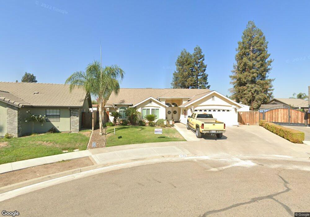
2175 De Foe Ct Tulare, CA 93274
Northeast Tulare NeighborhoodEstimated Value: $387,000 - $417,000
3
Beds
2
Baths
1,660
Sq Ft
$241/Sq Ft
Est. Value
About This Home
This home is located at 2175 De Foe Ct, Tulare, CA 93274 and is currently estimated at $399,844, approximately $240 per square foot. 2175 De Foe Ct is a home located in Tulare County with nearby schools including Garden Elementary School, Cherry Avenue Middle School, and Tulare Western High School.
Ownership History
Date
Name
Owned For
Owner Type
Purchase Details
Closed on
Oct 15, 2019
Sold by
Mejia Joe Raymond and Mejia Ermelinda
Bought by
Mejia Joe Raymond and Mejia Ermelinda
Current Estimated Value
Purchase Details
Closed on
Nov 13, 2014
Sold by
Couto Larry
Bought by
Meji Joe R and Mejia Ermelinda
Home Financials for this Owner
Home Financials are based on the most recent Mortgage that was taken out on this home.
Original Mortgage
$160,000
Outstanding Balance
$123,016
Interest Rate
4.1%
Mortgage Type
New Conventional
Estimated Equity
$276,828
Purchase Details
Closed on
Nov 9, 2011
Sold by
U S Bank National Association
Bought by
Couto Larry and Couto Janice
Home Financials for this Owner
Home Financials are based on the most recent Mortgage that was taken out on this home.
Original Mortgage
$99,200
Interest Rate
4.06%
Mortgage Type
New Conventional
Purchase Details
Closed on
Mar 28, 2011
Sold by
Barnard Craig
Bought by
U S Bank National Association
Purchase Details
Closed on
Oct 27, 2004
Sold by
Delco Shelby L
Bought by
Barnard Craig
Home Financials for this Owner
Home Financials are based on the most recent Mortgage that was taken out on this home.
Original Mortgage
$189,000
Interest Rate
6.2%
Mortgage Type
Purchase Money Mortgage
Purchase Details
Closed on
Jun 25, 2003
Sold by
Deatherage Tom
Bought by
Barnard Craig and Delco Shelby L
Home Financials for this Owner
Home Financials are based on the most recent Mortgage that was taken out on this home.
Original Mortgage
$159,300
Interest Rate
5.18%
Mortgage Type
Purchase Money Mortgage
Purchase Details
Closed on
Apr 11, 1996
Sold by
Allen Brian L
Bought by
Deatherage Tom and Deatherage Deana
Home Financials for this Owner
Home Financials are based on the most recent Mortgage that was taken out on this home.
Original Mortgage
$109,600
Interest Rate
7.97%
Create a Home Valuation Report for This Property
The Home Valuation Report is an in-depth analysis detailing your home's value as well as a comparison with similar homes in the area
Home Values in the Area
Average Home Value in this Area
Purchase History
| Date | Buyer | Sale Price | Title Company |
|---|---|---|---|
| Mejia Joe Raymond | -- | None Available | |
| Mejia Joe Raymond | -- | None Available | |
| Meji Joe R | $200,000 | Orange Coast Title Company | |
| Couto Larry | $124,000 | Servicelink | |
| U S Bank National Association | $122,000 | Servicelink | |
| Barnard Craig | -- | Security Union Title | |
| Barnard Craig | $177,000 | Chicago Title Co | |
| Deatherage Tom | $137,000 | Fidelity National Title |
Source: Public Records
Mortgage History
| Date | Status | Borrower | Loan Amount |
|---|---|---|---|
| Open | Meji Joe R | $160,000 | |
| Previous Owner | Couto Larry | $99,200 | |
| Previous Owner | Barnard Craig | $189,000 | |
| Previous Owner | Barnard Craig | $159,300 | |
| Previous Owner | Deatherage Tom | $109,600 |
Source: Public Records
Tax History Compared to Growth
Tax History
| Year | Tax Paid | Tax Assessment Tax Assessment Total Assessment is a certain percentage of the fair market value that is determined by local assessors to be the total taxable value of land and additions on the property. | Land | Improvement |
|---|---|---|---|---|
| 2025 | $2,728 | $257,778 | $60,091 | $197,687 |
| 2024 | $2,728 | $252,724 | $58,913 | $193,811 |
| 2023 | $2,657 | $247,769 | $57,758 | $190,011 |
| 2022 | $2,578 | $242,912 | $56,626 | $186,286 |
| 2021 | $2,544 | $238,149 | $55,516 | $182,633 |
| 2020 | $2,585 | $235,707 | $54,947 | $180,760 |
| 2019 | $2,649 | $231,086 | $53,870 | $177,216 |
| 2018 | $2,605 | $226,555 | $52,814 | $173,741 |
| 2017 | $2,579 | $222,112 | $51,778 | $170,334 |
| 2016 | $2,292 | $203,051 | $50,763 | $152,288 |
| 2015 | $1,487 | $200,000 | $50,000 | $150,000 |
| 2014 | $1,487 | $127,054 | $30,739 | $96,315 |
Source: Public Records
Map
Nearby Homes
- 1977 Irving Cir
- 384 Mitchell Ave
- 382 Hemmingway Ct
- 183 Oaks Ct
- 148 E Gail Ave
- 2459 N Oaks St Unit 37
- 2459 N Oaks St Unit 127
- 2459 N Oaks St Unit 46
- 2459 N Oaks St Unit 120
- 2459 N Oaks St Unit 28
- 1 M St
- 0 Cartmill Ave Ave Unit 121103
- 433 Jackson Ave
- 384 E Gail Ave
- 288 E Berkeley Ave
- 1266 N H St
- 1721 Cotton Ct
- 1110 Grove Dr
- 1145 N M St
- 1149 N E St
- 2189 De Foe Ct
- 2158 Alcott St
- 2164 Alcott St
- 2153 De Foe Ct
- 250 Mark Twain Ave
- 227 W Dickens Ave
- 239 W Dickens Ave
- 2190 De Foe Ct
- 215 W Dickens Ave
- 2190 Defoe Ct
- 251 W Dickens Ave
- 2152 De Foe Ct
- 2174 De Foe Ct
- 18 Alcott St
- 20 Alcott St
- 17 Alcott St
- 201 W Dickens Ave
- 227 Mark Twain Ave
- 201 SW Dickens
- 215 Mark Twain Ave