
Seller's Agent in 2025
Carol Shroka
CS Real Estate
(630) 673-9038
23 in this area
88 Total Sales
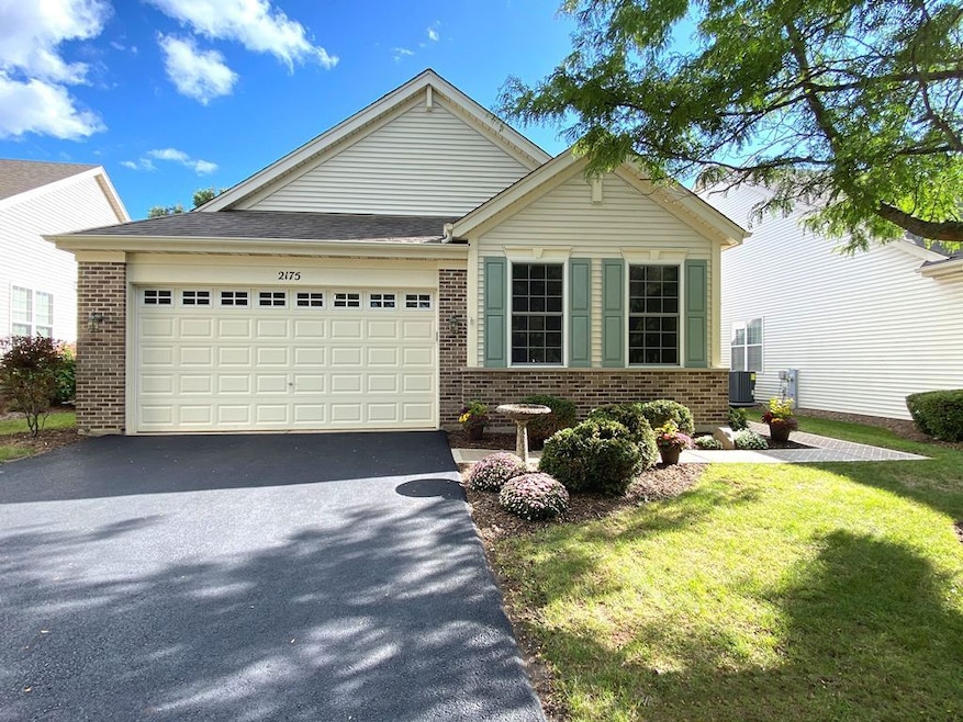
This home is located at 2175 Oleander Ct, Aurora, IL 60502 and is currently priced at $499,500, approximately $234 per square foot. This property was built in 2005. 2175 Oleander Ct is a home located in DuPage County with nearby schools including Mabel O Donnell Elementary School, Simmons Middle School, and East Aurora High School.
Last Agent to Sell the Property
CS Real Estate License #471011101 Listed on: 09/23/2025
| Date | Type | Sale Price | Title Company |
|---|---|---|---|
| Quit Claim Deed | -- | None Listed On Document | |
| Deed | $499,500 | Advocus National Title | |
| Interfamily Deed Transfer | -- | None Available | |
| Warranty Deed | $354,000 | Chicago Title Insurance Comp |
| Date | Status | Loan Amount | Loan Type |
|---|---|---|---|
| Previous Owner | $199,500 | New Conventional | |
| Previous Owner | $80,000 | Fannie Mae Freddie Mac |
| Date | Event | Price | List to Sale | Price per Sq Ft |
|---|---|---|---|---|
| 12/02/2025 12/02/25 | Sold | $499,500 | 0.0% | $234 / Sq Ft |
| 10/28/2025 10/28/25 | Pending | -- | -- | -- |
| 10/21/2025 10/21/25 | For Sale | $499,500 | 0.0% | $234 / Sq Ft |
| 10/14/2025 10/14/25 | Off Market | $499,500 | -- | -- |
| 10/14/2025 10/14/25 | For Sale | $499,500 | 0.0% | $234 / Sq Ft |
| 10/08/2025 10/08/25 | Pending | -- | -- | -- |
| 09/23/2025 09/23/25 | For Sale | $499,500 | -- | $234 / Sq Ft |
| Year | Tax Paid | Tax Assessment Tax Assessment Total Assessment is a certain percentage of the fair market value that is determined by local assessors to be the total taxable value of land and additions on the property. | Land | Improvement |
|---|---|---|---|---|
| 2024 | $10,034 | $162,378 | $30,536 | $131,842 |
| 2023 | $9,646 | $145,084 | $27,284 | $117,800 |
| 2022 | $9,222 | $132,376 | $24,894 | $107,482 |
| 2021 | $9,061 | $123,244 | $23,177 | $100,067 |
| 2020 | $9,511 | $125,366 | $21,528 | $103,838 |
| 2019 | $9,266 | $116,155 | $19,946 | $96,209 |
| 2018 | $9,473 | $115,033 | $18,450 | $96,583 |
| 2017 | $10,369 | $116,729 | $19,832 | $96,897 |
| 2016 | $10,036 | $106,372 | $18,981 | $87,391 |
| 2015 | -- | $95,939 | $16,322 | $79,617 |
| 2014 | -- | $88,110 | $13,605 | $74,505 |
| 2013 | -- | $83,806 | $14,442 | $69,364 |
Seller's Agent in 2025
Carol Shroka
CS Real Estate
(630) 673-9038
23 in this area
88 Total Sales
Buyer's Agent in 2025
Deb Ritter
Keller Williams Premiere Properties
(630) 918-4476
1 in this area
84 Total Sales
Source: Midwest Real Estate Data (MRED)
MLS Number: 12478475
APN: 15-12-478-022
Disclaimer: Certain information contained herein is derived from information provided by parties other than Homes.com. All information provided is deemed reliable, but is not guaranteed to be accurate and should be independently verified.
![]() Based on information submitted to the MLS GRID. All data is obtained from various sources and may not have been verified by broker or MLS GRID. Supplied Open House Information is subject to change without notice. All information should be independently reviewed and verified for accuracy. Properties may or may not be listed by the office/agent presenting the information. Some IDX listings have been excluded from this website.
Based on information submitted to the MLS GRID. All data is obtained from various sources and may not have been verified by broker or MLS GRID. Supplied Open House Information is subject to change without notice. All information should be independently reviewed and verified for accuracy. Properties may or may not be listed by the office/agent presenting the information. Some IDX listings have been excluded from this website.
Based on information submitted to the MLS GRID
Ask me questions while you tour the home.