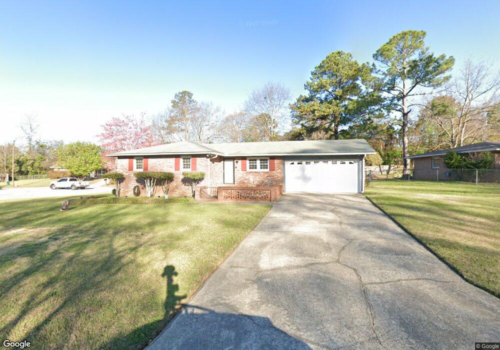
218 Randy Cir Warner Robins, GA 31088
Estimated Value: $154,796 - $175,000
Studio
2
Baths
1,300
Sq Ft
$126/Sq Ft
Est. Value
About This Home
This home is located at 218 Randy Cir, Warner Robins, GA 31088 and is currently estimated at $163,449, approximately $125 per square foot. 218 Randy Cir is a home located in Houston County with nearby schools including Russell Elementary School, Warner Robins Middle School, and Warner Robins High School.
Ownership History
Date
Name
Owned For
Owner Type
Purchase Details
Closed on
Jul 5, 2011
Sold by
The City Of Warner Robins
Bought by
Brooks Angela D
Current Estimated Value
Purchase Details
Closed on
Oct 27, 2000
Sold by
Camille Rusty J and Michelle R*
Bought by
Brooks Angela D
Purchase Details
Closed on
Jan 26, 1995
Sold by
Brege David F and Brege Jeanne
Bought by
Camille Rusty J and Michelle R*
Purchase Details
Closed on
Apr 25, 1975
Sold by
J R S Co Inc
Bought by
Brege David F and Brege Jeanne
Purchase Details
Closed on
Jan 2, 1975
Sold by
Brooks Angela D
Bought by
J R S Co Inc
Create a Home Valuation Report for This Property
The Home Valuation Report is an in-depth analysis detailing your home's value as well as a comparison with similar homes in the area
Home Values in the Area
Average Home Value in this Area
Purchase History
| Date | Buyer | Sale Price | Title Company |
|---|---|---|---|
| Brooks Angela D | -- | None Available | |
| Brooks Angela D | $69,900 | -- | |
| Camille Rusty J | $63,000 | -- | |
| Brege David F | $30,500 | -- | |
| J R S Co Inc | -- | -- |
Source: Public Records
Tax History
| Year | Tax Paid | Tax Assessment Tax Assessment Total Assessment is a certain percentage of the fair market value that is determined by local assessors to be the total taxable value of land and additions on the property. | Land | Improvement |
|---|---|---|---|---|
| 2025 | $1,542 | $58,160 | $8,000 | $50,160 |
| 2024 | $1,648 | $51,760 | $8,000 | $43,760 |
| 2023 | $1,253 | $39,400 | $8,000 | $31,400 |
| 2022 | $730 | $33,760 | $5,400 | $28,360 |
| 2021 | $596 | $27,760 | $5,400 | $22,360 |
| 2020 | $920 | $27,640 | $5,400 | $22,240 |
| 2019 | $596 | $27,640 | $5,400 | $22,240 |
| 2018 | $596 | $27,640 | $5,400 | $22,240 |
| 2017 | $596 | $27,640 | $5,400 | $22,240 |
| 2016 | $597 | $27,640 | $5,400 | $22,240 |
| 2015 | -- | $29,480 | $5,400 | $24,080 |
| 2014 | $295 | $29,480 | $5,400 | $24,080 |
| 2013 | $295 | $29,480 | $5,400 | $24,080 |
Source: Public Records
Map
Nearby Homes
- 114 Tommy Terrace
- 223 Randy Cir
- 213 Self St
- 1850 Russell Pkwy
- 0 Russell Pkwy Unit 10656199
- 114 Windsor Dr
- 118 Fox Glove Ct
- 25 & 26 Lot
- 209 Tracy Terrace
- 305 Bonnie Dr
- 223 Highland Dr
- 108 Woodsdale Dr
- 302 Creek Ridge Dr
- 104 Ridgedale Dr
- 119 Colonial Rd
- 101 Sunnybrook Ct
- 107 Woodfield Dr
- 103 Oakdale Dr
- 337 Mary Ln
- 505 Ashby Way
Your Personal Tour Guide
Ask me questions while you tour the home.