Estimated Value: $95,043 - $138,000
3
Beds
1
Bath
1,050
Sq Ft
$104/Sq Ft
Est. Value
About This Home
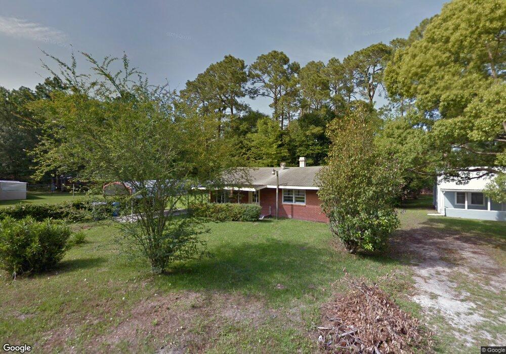
This home is located at 218 Rogers St, Jesup, GA 31545 and is currently estimated at $109,261, approximately $104 per square foot. 218 Rogers St is a home located in Wayne County with nearby schools including Martha Rawls Smith Elementary School, Arthur Williams Middle School, and Wayne County High School.
Ownership History
Date
Name
Owned For
Owner Type
Purchase Details
Closed on
May 24, 2023
Sold by
Oquinn Lonnie A
Bought by
Altamaha Acquisitions Llc
Current Estimated Value
Purchase Details
Closed on
Mar 31, 2017
Sold by
Wingate Maria L
Bought by
Oquinn Lonnie Andrew
Purchase Details
Closed on
Jun 5, 2014
Sold by
Collins Rita
Bought by
Wingate Maria L
Purchase Details
Closed on
Mar 4, 2014
Sold by
M & T Bank
Bought by
Federal Home Loan Mortgage Corporation
Purchase Details
Closed on
May 30, 2008
Sold by
Ocampo Maria
Bought by
Ocampo Gregory
Purchase Details
Closed on
Jun 13, 2006
Sold by
Pittman Eunive H
Bought by
Ocampo Maria
Purchase Details
Closed on
Mar 1, 1984
Create a Home Valuation Report for This Property
The Home Valuation Report is an in-depth analysis detailing your home's value as well as a comparison with similar homes in the area
Purchase History
| Date | Buyer | Sale Price | Title Company |
|---|---|---|---|
| Altamaha Acquisitions Llc | -- | -- | |
| Oquinn Lonnie Andrew | $38,000 | -- | |
| Wingate Maria L | -- | -- | |
| Collins Rita | $15,000 | -- | |
| Federal Home Loan Mortgage Corporation | -- | -- | |
| M & T Bank | -- | -- | |
| Ocampo Gregory | -- | -- | |
| Ocampo Maria | $45,000 | -- | |
| -- | -- | -- |
Source: Public Records
Tax History
| Year | Tax Paid | Tax Assessment Tax Assessment Total Assessment is a certain percentage of the fair market value that is determined by local assessors to be the total taxable value of land and additions on the property. | Land | Improvement |
|---|---|---|---|---|
| 2025 | $766 | $24,267 | $2,210 | $22,057 |
| 2024 | $719 | $23,525 | $2,210 | $21,315 |
| 2023 | $437 | $14,891 | $2,210 | $12,681 |
| 2022 | $469 | $14,891 | $2,210 | $12,681 |
| 2021 | $502 | $14,891 | $2,210 | $12,681 |
| 2020 | $519 | $14,891 | $2,210 | $12,681 |
| 2019 | $535 | $14,891 | $2,210 | $12,681 |
| 2018 | $535 | $14,891 | $2,210 | $12,681 |
| 2017 | $460 | $14,891 | $2,210 | $12,681 |
| 2016 | $446 | $14,891 | $2,210 | $12,681 |
| 2014 | $447 | $14,891 | $2,210 | $12,681 |
| 2013 | -- | $14,891 | $2,210 | $12,681 |
Source: Public Records
Map
Nearby Homes
- 128 Pinebloom Dr
- 806 S Macon St
- 479 Brannen St
- 0 Peachtree Dr
- 195 Hollywood Ave Unit 3
- 612 S Macon St
- 761 S 3rd St
- 761 S 4th St
- 560 S Macon St
- 511 S Macon St
- 2324 Old Screven Rd
- 686 S 4th St
- 757 Old Screven Rd
- 639 S Wayne St
- 535 S 4th St
- 163 Conway Dr
- 545 S 5th St
- 387 S 2nd St
- 548 S 5th St
- 705 S Elm St
Your Personal Tour Guide
Ask me questions while you tour the home.