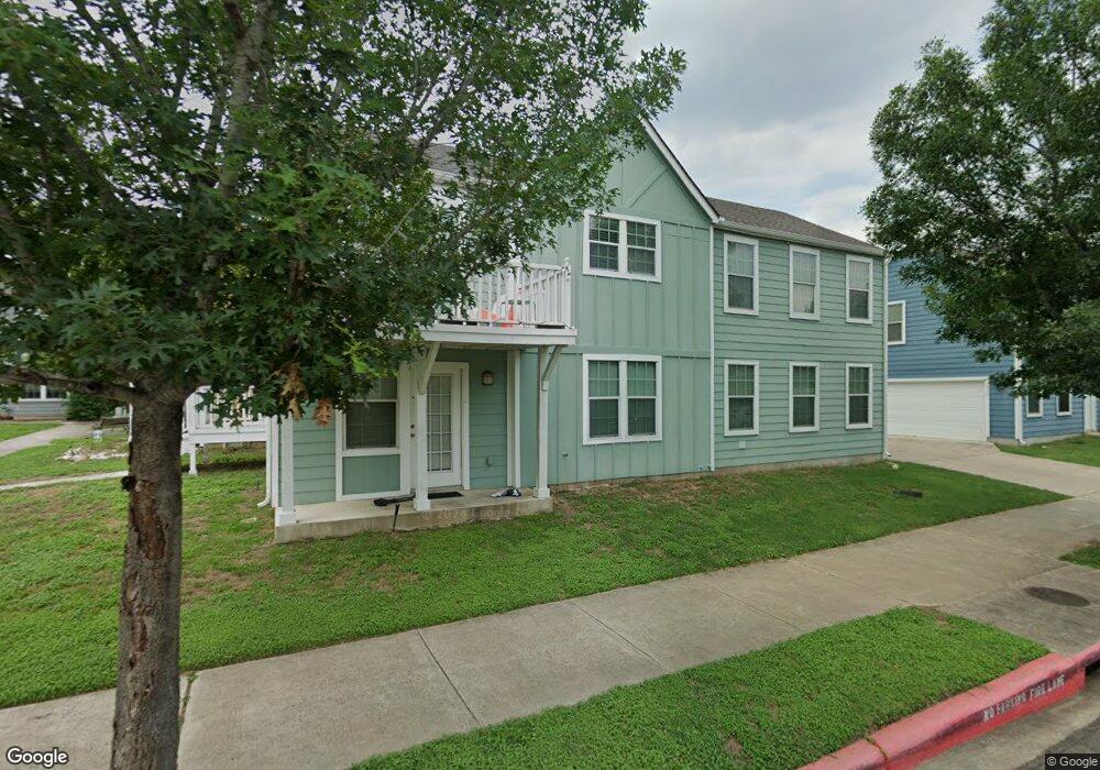
218 Trestle Tree Unit C San Marcos, TX 78666
Estimated Value: $250,000 - $283,000
1
Bed
1
Bath
540
Sq Ft
$490/Sq Ft
Est. Value
About This Home
This home is located at 218 Trestle Tree Unit C, San Marcos, TX 78666 and is currently estimated at $264,810, approximately $490 per square foot. 218 Trestle Tree Unit C is a home located in Hays County with nearby schools including Travis Elementary School, Dorris Miller Middle School, and San Marcos High School.
Ownership History
Date
Name
Owned For
Owner Type
Purchase Details
Closed on
Oct 9, 2019
Sold by
Young Michael and Young Amy
Bought by
Malone Wayne D and Malone Sherrie J
Current Estimated Value
Home Financials for this Owner
Home Financials are based on the most recent Mortgage that was taken out on this home.
Original Mortgage
$170,100
Outstanding Balance
$148,710
Interest Rate
3.4%
Mortgage Type
New Conventional
Estimated Equity
$116,100
Purchase Details
Closed on
Jun 17, 2011
Sold by
Bigelow San Marcos Development Llc
Bought by
Young Robert E and Young Amy
Home Financials for this Owner
Home Financials are based on the most recent Mortgage that was taken out on this home.
Original Mortgage
$114,880
Interest Rate
4.74%
Mortgage Type
New Conventional
Create a Home Valuation Report for This Property
The Home Valuation Report is an in-depth analysis detailing your home's value as well as a comparison with similar homes in the area
Home Values in the Area
Average Home Value in this Area
Purchase History
| Date | Buyer | Sale Price | Title Company |
|---|---|---|---|
| Malone Wayne D | -- | None Available | |
| Young Robert E | -- | San Marcos Title |
Source: Public Records
Mortgage History
| Date | Status | Borrower | Loan Amount |
|---|---|---|---|
| Open | Malone Wayne D | $170,100 | |
| Previous Owner | Young Robert E | $114,880 |
Source: Public Records
Tax History Compared to Growth
Tax History
| Year | Tax Paid | Tax Assessment Tax Assessment Total Assessment is a certain percentage of the fair market value that is determined by local assessors to be the total taxable value of land and additions on the property. | Land | Improvement |
|---|---|---|---|---|
| 2025 | $5,964 | $297,900 | $48,080 | $249,820 |
| 2024 | $5,964 | $303,020 | $48,080 | $254,940 |
| 2023 | $6,038 | $317,471 | $50,880 | $266,591 |
| 2022 | $5,881 | $287,000 | $43,120 | $243,880 |
| 2021 | $4,542 | $206,070 | $17,220 | $188,850 |
| 2020 | $4,277 | $194,030 | $16,790 | $177,240 |
| 2019 | $4,635 | $188,280 | $16,790 | $171,490 |
| 2018 | $4,397 | $177,820 | $13,990 | $163,830 |
| 2017 | $4,025 | $167,410 | $10,300 | $157,110 |
| 2016 | $3,580 | $148,920 | $10,300 | $138,620 |
| 2015 | $3,454 | $140,730 | $10,270 | $130,460 |
Source: Public Records
Map
Nearby Homes
- 201 Trestle Tree
- 210 Rush Haven
- 226 Trestle Tree
- 249 Trestle Tree
- 122 Rush Haven
- 122 Rush Haven Unit F093
- 252 Newberry Trail
- 316 Perry St
- 330 Trestle Tree Unit 22
- 323 Rachel St
- 340 Trestle Tree
- 338 Newberry Trail
- 3245 N Old Bastrop Hwy
- 329 Newberry Trail
- 244 Soul Harvest Pass
- 1322 N Interstate 35
- 000A Pecan St
- 000 Pecan St
- 709 Uhland Rd
- 1624 Aquarena Springs Dr Unit 115
- 218 Trestle Tree
- 220 Trestle Tree
- 222 Trestle Tree
- 224 Trestle Tree
- 224 Trestle Tree
- 216 Trestle Tree
- 216 Trestle Tree Unit B
- 210 Trestle Tree
- 226 Trestle Tree
- 232 Trestle Tree
- 228 Trestle Tree Unit 228
- 228 Trestle Tree Unit B
- 232 Trestle Tree Unit 101
- 214 Trestle Tree
- 214 Trestle Tree Unit 122
- 214 Trestle Tree
- 230 Trestle Tree
- 230 Trestle Tree
- 230 Trestle Tree Unit 102
- 208 Trestle Tree Unit A