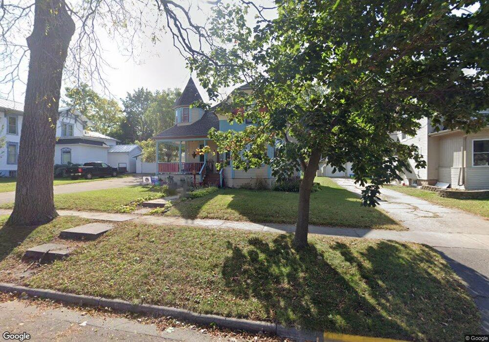
218 W Cook St New London, WI 54961
Estimated Value: $180,000 - $241,218
4
Beds
2
Baths
1,619
Sq Ft
$130/Sq Ft
Est. Value
About This Home
This home is located at 218 W Cook St, New London, WI 54961 and is currently estimated at $210,609, approximately $130 per square foot. 218 W Cook St is a home located in Waupaca County with nearby schools including Lincoln Elementary School, New London Middle School, and New London High School.
Ownership History
Date
Name
Owned For
Owner Type
Purchase Details
Closed on
Dec 30, 2011
Sold by
Winkler Michael V and Winkler Becky L
Bought by
Uvaas Benjamin J and Uvaas Lindsey Ck
Current Estimated Value
Home Financials for this Owner
Home Financials are based on the most recent Mortgage that was taken out on this home.
Original Mortgage
$124,657
Outstanding Balance
$86,557
Interest Rate
4.25%
Mortgage Type
FHA
Estimated Equity
$124,052
Create a Home Valuation Report for This Property
The Home Valuation Report is an in-depth analysis detailing your home's value as well as a comparison with similar homes in the area
Home Values in the Area
Average Home Value in this Area
Purchase History
| Date | Buyer | Sale Price | Title Company |
|---|---|---|---|
| Uvaas Benjamin J | $127,900 | None Available |
Source: Public Records
Mortgage History
| Date | Status | Borrower | Loan Amount |
|---|---|---|---|
| Open | Uvaas Benjamin J | $124,657 |
Source: Public Records
Tax History Compared to Growth
Tax History
| Year | Tax Paid | Tax Assessment Tax Assessment Total Assessment is a certain percentage of the fair market value that is determined by local assessors to be the total taxable value of land and additions on the property. | Land | Improvement |
|---|---|---|---|---|
| 2024 | $3,458 | $147,300 | $13,900 | $133,400 |
| 2023 | $3,458 | $147,300 | $13,900 | $133,400 |
| 2022 | $3,232 | $147,300 | $13,900 | $133,400 |
| 2021 | $3,283 | $147,300 | $13,900 | $133,400 |
| 2020 | $3,334 | $147,300 | $13,900 | $133,400 |
| 2019 | $3,277 | $147,300 | $13,900 | $133,400 |
| 2018 | $3,133 | $147,300 | $13,900 | $133,400 |
| 2017 | $3,504 | $147,300 | $13,900 | $133,400 |
| 2016 | $3,381 | $146,900 | $13,900 | $133,000 |
| 2015 | $3,464 | $146,900 | $13,900 | $133,000 |
| 2014 | $3,402 | $146,900 | $13,900 | $133,000 |
| 2013 | $3,486 | $146,900 | $13,900 | $133,000 |
Source: Public Records
Map
Nearby Homes
- 200 W Beacon Ave
- 0 Shawano St Unit 50295803
- 0 Shawano St Unit 50257475
- 903 Smith St
- 211 E Wolf River Ave
- 114 E North Water St
- 1010 Smith St
- 401 E Beacon Ave
- 1011 Lawrence St
- 610 W Pine St
- 803 W North Water St
- 501 W Waupaca St
- 514 E Beacon Ave
- 1109 Algoma St
- 514 E Pine St
- 1420 Division St
- 102 E Cameron St
- 1801 Southland Ln
- 1605 Cedarhurst Dr
- 1835 Southland Ln
- 302 W Cook St
- 212 W Cook St
- 304 W Cook St
- 219 W Beacon Ave
- 215 W Beacon Ave
- 305 W Beacon Ave
- 211 W Beacon Ave
- 204 W Cook St
- 217 W Cook St
- 312 W Cook St
- 313 W Beacon Ave
- 202 W Cook St
- 203 W Beacon Ave
- 313 W Cook St
- 415 Smith St
- 218 W Spring St
- 214 W Spring St
- 302 W Beacon Ave
- 210 W Spring St
- 306 W Spring St