Estimated Value: $367,548 - $426,000
4
Beds
3
Baths
1,936
Sq Ft
$205/Sq Ft
Est. Value
About This Home
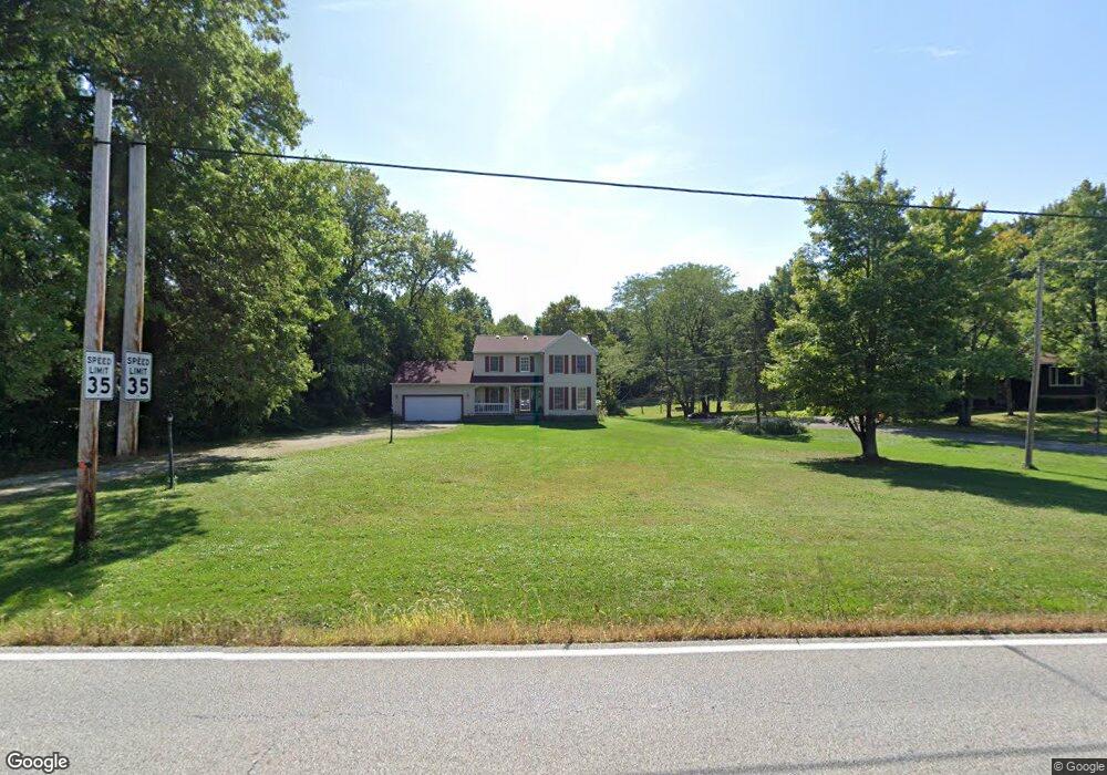
This home is located at 2182 Norton Rd, Stow, OH 44224 and is currently estimated at $396,137, approximately $204 per square foot. 2182 Norton Rd is a home located in Summit County with nearby schools including Stow-Munroe Falls High School, Primrose School of Hudson, and Seton Catholic Elementary School.
Ownership History
Date
Name
Owned For
Owner Type
Purchase Details
Closed on
Aug 26, 2024
Sold by
Robert N Dinkelman N and Robert Shirley A
Bought by
Dinkelman Randal
Current Estimated Value
Purchase Details
Closed on
Jul 2, 2024
Sold by
Dinkelman Linda G
Bought by
Dinkelman Randal T
Create a Home Valuation Report for This Property
The Home Valuation Report is an in-depth analysis detailing your home's value as well as a comparison with similar homes in the area
Home Values in the Area
Average Home Value in this Area
Purchase History
| Date | Buyer | Sale Price | Title Company |
|---|---|---|---|
| Dinkelman Randal | -- | None Listed On Document | |
| Dinkelman Randal T | -- | None Listed On Document |
Source: Public Records
Tax History
| Year | Tax Paid | Tax Assessment Tax Assessment Total Assessment is a certain percentage of the fair market value that is determined by local assessors to be the total taxable value of land and additions on the property. | Land | Improvement |
|---|---|---|---|---|
| 2024 | $5,642 | $100,080 | $24,602 | $75,478 |
| 2023 | $5,642 | $100,080 | $24,602 | $75,478 |
| 2022 | $4,962 | $77,676 | $19,072 | $58,604 |
| 2021 | $4,443 | $77,676 | $19,072 | $58,604 |
| 2020 | $4,366 | $77,670 | $19,070 | $58,600 |
| 2019 | $4,217 | $70,110 | $16,830 | $53,280 |
| 2018 | $4,149 | $70,110 | $16,830 | $53,280 |
| 2017 | $4,131 | $70,110 | $16,830 | $53,280 |
| 2016 | $4,252 | $67,860 | $16,830 | $51,030 |
| 2015 | $4,131 | $67,860 | $16,830 | $51,030 |
| 2014 | $4,135 | $67,860 | $16,830 | $51,030 |
| 2013 | $3,835 | $63,270 | $16,830 | $46,440 |
Source: Public Records
Map
Nearby Homes
- 1995 Weston Dr
- V/L Norton Rd
- 5091 Ridge Meadow Dr
- 2221 Crockett Cir
- 2188 Duxbury
- 5361 Diana Lynn Dr
- 1620 Sapphire Dr
- 2279 Becket Cir
- 5123 Sodalite Dr
- 4916 Friar Rd Unit B
- 4704 Red Willow Rd
- 1525 Spruce Hill Dr
- 4909 Fishcreek Rd
- 4623 Cox Dr
- 4424 Timberdale Dr Unit 4428
- 0 Hibbard Dr
- 1961 Arndale Rd
- 4399-4403 Cherryhurst Dr
- 2072 White Oak Dr Unit 2076
- 4556 Fishcreek Rd
- 2202 Norton Rd
- 4353 Westchester Ct
- 2214 Norton Rd
- 2158 Norton Rd
- 5350 Duffield Dr
- 2170 Norton Rd
- 4361 Westchester Ct
- 4356 Westchester Ct
- 2146 Norton Rd
- 5368 Duffield Dr
- 4373 Westchester Ct
- 4364 Westchester Ct
- 2234 Norton Rd
- 2132 Norton Rd
- 5365 Duffield Dr
- 4376 Westchester Ct
- 2259 Norton Rd
- 3997 Deacon Ct
- 4385 Westchester Ct
- 5375 Duffield Dr
Your Personal Tour Guide
Ask me questions while you tour the home.