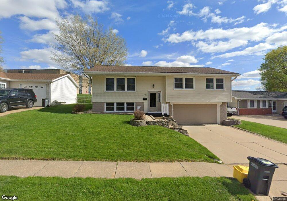
2186 Key Way Dubuque, IA 52002
Estimated Value: $225,000 - $239,000
3
Beds
2
Baths
1,686
Sq Ft
$139/Sq Ft
Est. Value
About This Home
This home is located at 2186 Key Way, Dubuque, IA 52002 and is currently estimated at $234,595, approximately $139 per square foot. 2186 Key Way is a home located in Dubuque County with nearby schools including John Kennedy Elementary School, Eleanor Roosevelt Middle School, and Hempstead High School.
Ownership History
Date
Name
Owned For
Owner Type
Purchase Details
Closed on
Oct 7, 2011
Sold by
Haupert Frances M
Bought by
May Nicholas J and May Leann S
Current Estimated Value
Home Financials for this Owner
Home Financials are based on the most recent Mortgage that was taken out on this home.
Original Mortgage
$120,175
Outstanding Balance
$82,138
Interest Rate
4.22%
Mortgage Type
New Conventional
Estimated Equity
$152,457
Purchase Details
Closed on
Jun 21, 2007
Sold by
Haupert Richard J and Haupetr Christine M
Bought by
Haupert Richard J and Haupetr Christine M
Create a Home Valuation Report for This Property
The Home Valuation Report is an in-depth analysis detailing your home's value as well as a comparison with similar homes in the area
Purchase History
We collect this data history from publicly available records. To have your information removed, we recommend requesting removal directly through your county’s website.
| Date | Buyer | Sale Price | Title Company |
|---|---|---|---|
| May Nicholas J | $126,500 | None Available | |
| Haupert Richard J | -- | None Available |
Source: Public Records
Mortgage History
We collect this data history from publicly available records. To have your information removed, we recommend requesting removal directly through your county’s website.
| Date | Status | Borrower | Loan Amount |
|---|---|---|---|
| Open | May Nicholas J | $120,175 |
Source: Public Records
Tax History
| Year | Tax Paid | Tax Assessment Tax Assessment Total Assessment is a certain percentage of the fair market value that is determined by local assessors to be the total taxable value of land and additions on the property. | Land | Improvement |
|---|---|---|---|---|
| 2025 | $2,998 | $225,000 | $40,900 | $184,100 |
| 2024 | $2,998 | $208,500 | $35,500 | $173,000 |
| 2023 | $2,940 | $210,600 | $35,500 | $175,100 |
| 2022 | $2,768 | $167,320 | $31,980 | $135,340 |
| 2021 | $2,768 | $167,320 | $31,980 | $135,340 |
| 2020 | $2,724 | $153,190 | $31,980 | $121,210 |
| 2019 | $2,706 | $153,190 | $31,980 | $121,210 |
| 2018 | $2,664 | $145,510 | $31,980 | $113,530 |
| 2017 | $2,646 | $145,510 | $31,980 | $113,530 |
| 2016 | $2,390 | $137,050 | $31,980 | $105,070 |
| 2015 | $2,390 | $126,340 | $31,980 | $94,360 |
| 2014 | $2,258 | $122,710 | $31,980 | $90,730 |
Source: Public Records
Map
Nearby Homes
- 2148 Graham Cir
- 2244 Saint John Dr
- 2305 Pasadena #67 Dr
- 2281 Pasadena #57 Dr
- 3280 Asbury Rd
- 3501 Asbury Rd
- 3615 Hillcrest Rd
- 3098 Foothill Ct
- 1862 Hansel Dr
- 3195 Kaufmann Ave
- 2068 Rosemont St
- 1913 Clifford St
- 2820 John F. Kennedy Rd
- 1975 Rosemont St
- 3040 Kaufmann Ave
- 3005 Saint Anne Dr
- 3920 Hillcrest Rd
- 3560 Pennsylvania Ave Unit 6
- 3416 Glencove Ln
- 3989 Hillcrest Rd
- 2183 Key Way
- 1512 South Ave Ave
- 2181 Key Way
- 2187 Key Way
- 2184 Key Way
- 2194 Southway Dr
- 2180 Key Way Dr
- 2180 Key Way
- 2200 Del Monaco Dr
- 2179 Key Way
- 2202 Southway Dr
- 2188 Key Way
- 2189 Key Way Dr
- 2189 Key Way
- 2178 Key Way
- 2207 Del Monaco Dr
- 3398 Venture Ct
- 2189 Southway Dr
- 2206 Southway Dr
- 2193 South Way
Your Personal Tour Guide
Ask me questions while you tour the home.