Estimated Value: $167,000 - $189,000
3
Beds
2
Baths
1,252
Sq Ft
$145/Sq Ft
Est. Value
About This Home
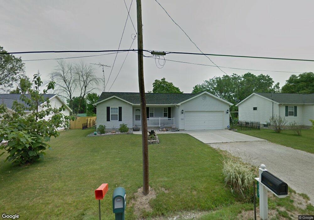
This home is located at 2187 Anoka St, Flint, MI 48532 and is currently estimated at $181,868, approximately $145 per square foot. 2187 Anoka St is a home located in Genesee County with nearby schools including Carman-Ainsworth High School, Genesee STEM Academy, and St. Paul Lutheran School.
Ownership History
Date
Name
Owned For
Owner Type
Purchase Details
Closed on
Jun 19, 2025
Sold by
Selvera Connie K
Bought by
Selvera Connie K
Current Estimated Value
Purchase Details
Closed on
May 7, 2018
Sold by
Selvera Connie K
Bought by
Selvera Connie K and Heit Gerald J
Purchase Details
Closed on
Sep 1, 2004
Sold by
Warner David G and Warner Julia L
Bought by
Selvera Connie K
Purchase Details
Closed on
Jun 30, 2004
Sold by
Warner David and Warner Julia L
Bought by
Selvera Connie K
Purchase Details
Closed on
Feb 18, 2003
Sold by
Nunley Bobby G and Nunley Robin
Bought by
Warner David and Piotrowski Martin J
Create a Home Valuation Report for This Property
The Home Valuation Report is an in-depth analysis detailing your home's value as well as a comparison with similar homes in the area
Home Values in the Area
Average Home Value in this Area
Purchase History
| Date | Buyer | Sale Price | Title Company |
|---|---|---|---|
| Selvera Connie K | -- | None Listed On Document | |
| Selvera Connie K | -- | None Available | |
| Selvera Connie K | $125,000 | Metropolitan Title Company | |
| Selvera Connie K | -- | Metropolitan Title Company | |
| Warner David | $29,900 | Metropolitan Title Company |
Source: Public Records
Tax History Compared to Growth
Tax History
| Year | Tax Paid | Tax Assessment Tax Assessment Total Assessment is a certain percentage of the fair market value that is determined by local assessors to be the total taxable value of land and additions on the property. | Land | Improvement |
|---|---|---|---|---|
| 2025 | $1,748 | $81,400 | $0 | $0 |
| 2024 | $899 | $72,700 | $0 | $0 |
| 2023 | $858 | $58,400 | $0 | $0 |
| 2022 | $766 | $52,500 | $0 | $0 |
| 2021 | $1,542 | $48,200 | $0 | $0 |
| 2020 | $771 | $40,700 | $0 | $0 |
| 2019 | $760 | $34,100 | $0 | $0 |
| 2018 | $1,617 | $43,100 | $0 | $0 |
| 2017 | $1,559 | $43,100 | $0 | $0 |
| 2016 | $1,599 | $39,400 | $0 | $0 |
| 2015 | $1,456 | $38,000 | $0 | $0 |
| 2014 | $864 | $36,200 | $0 | $0 |
| 2012 | -- | $42,100 | $42,100 | $0 |
Source: Public Records
Map
Nearby Homes
- 18.41 Taft Rd
- 2470 Tandy Dr
- 10 Acres T A Mansour Blvd
- 2468 Ketzler Dr
- 1540 Pound Dr
- 2496 Ketzler Dr
- 3321 Hogarth Ave
- 3011 Curtis Dr
- 3277 Whitney Ave
- 4474 Corunna Rd
- 1455 S Linden Rd
- 3045 Old Farm Rd
- VL Clairmont St
- 4480 Corunna Rd
- 4335 Lennon Rd
- 3075 Wagon Trail
- 1600 Houran St
- 1574 Houran St
- 4490 W Lennon Rd
- 0 Charter Dr Unit 50153638
- 2193 Anoka St
- 2181 Anoka St
- 2203 Anoka St
- 2173 Anoka St
- 2184 Anoka St
- 2176 Eberly Rd
- 2200 Anoka St
- 2170 Eberly Rd
- 4143 Corbin Dr
- 2158 Eberly Rd
- 2166 Anoka St
- 2189 Monaco St
- 2157 Anoka St
- 2197 Monaco St
- 2177 Monaco St
- 4164 Larchmont St
- 2160 Anoka St
- 4135 Corbin Dr
- 4135 Corbin Dr Unit DRIVE
- 2216 Anoka St