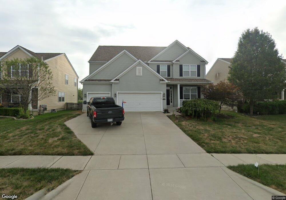
219 Honey Locust Ln Commercial Point, OH 43116
Estimated Value: $420,000 - $456,000
4
Beds
3
Baths
2,846
Sq Ft
$153/Sq Ft
Est. Value
About This Home
This home is located at 219 Honey Locust Ln, Commercial Point, OH 43116 and is currently estimated at $436,508, approximately $153 per square foot. 219 Honey Locust Ln is a home.
Ownership History
Date
Name
Owned For
Owner Type
Purchase Details
Closed on
Dec 24, 2014
Sold by
Westport Homes Inc
Bought by
Clark Jason D and Clark Nicole B
Current Estimated Value
Home Financials for this Owner
Home Financials are based on the most recent Mortgage that was taken out on this home.
Original Mortgage
$193,315
Outstanding Balance
$148,242
Interest Rate
3.95%
Mortgage Type
New Conventional
Estimated Equity
$288,266
Purchase Details
Closed on
May 29, 2014
Sold by
Saddlebrook Development Llc
Bought by
Westport Homes Inc
Create a Home Valuation Report for This Property
The Home Valuation Report is an in-depth analysis detailing your home's value as well as a comparison with similar homes in the area
Home Values in the Area
Average Home Value in this Area
Purchase History
| Date | Buyer | Sale Price | Title Company |
|---|---|---|---|
| Clark Jason D | $258,400 | Talon Title Agency | |
| Westport Homes Inc | $124,000 | Talon Title Agency |
Source: Public Records
Mortgage History
| Date | Status | Borrower | Loan Amount |
|---|---|---|---|
| Open | Clark Jason D | $193,315 |
Source: Public Records
Tax History Compared to Growth
Tax History
| Year | Tax Paid | Tax Assessment Tax Assessment Total Assessment is a certain percentage of the fair market value that is determined by local assessors to be the total taxable value of land and additions on the property. | Land | Improvement |
|---|---|---|---|---|
| 2024 | -- | $132,680 | $12,820 | $119,860 |
| 2023 | $4,990 | $132,680 | $12,820 | $119,860 |
| 2022 | $4,293 | $104,860 | $10,680 | $94,180 |
| 2021 | $4,306 | $104,860 | $10,680 | $94,180 |
| 2020 | $4,307 | $104,860 | $10,680 | $94,180 |
| 2019 | $3,557 | $85,130 | $10,680 | $74,450 |
| 2018 | $3,769 | $96,720 | $10,680 | $86,040 |
| 2017 | $5,083 | $96,720 | $10,680 | $86,040 |
| 2016 | $3,413 | $85,170 | $8,170 | $77,000 |
| 2015 | $3,513 | $85,170 | $8,170 | $77,000 |
| 2014 | $270 | $6,530 | $6,530 | $0 |
Source: Public Records
Map
Nearby Homes
- 182 Honey Locust Ln
- 11044 Coontz Rd
- 186 Red Oak Ct
- 161 Chestnut Estates Dr
- 169 Chestnut Commons Dr
- 166 Rosewood Loop SE
- 7789 State Route 762
- 56 Chambers Bay Rd
- 294 Shady Hollow Dr
- 47 Front St
- 66 Genoa Cir
- 8143 Snyder Rd
- 62 Genoa Cir
- 55 Genoa Cir
- The Siebert Plan at Genoa Crossing
- The Hollandia B Plan at Genoa Crossing
- The Rainier Plan at Genoa Crossing
- The Petoskey Plan at Genoa Crossing
- 310 Genoa Rd
- 0 Lane Rd Unit 225004404
- 216 Honey Locust Ln
- 217 Honey Locust Ln
- 221 Honey Locust Ln
- 221 Honey Locust Ln Unit 208
- 214 Honey Locust Ln
- 215 Honey Locust Ln
- 223 Honey Locust Ln
- 218 Honey Locust Ln
- 213 Honey Locust Ln
- 212 Honey Locust Ln
- 206 Chestnut Estates Dr
- 225 Honey Locust Ln
- 220 Honey Locust Ln Unit 226
- 210 Honey Locust Ln
- 179 Cottonwood Place
- 211 Honey Locust Ln
- 227 Honey Locust Ln
- 177 Cottonwood Place Unit 153
- 204 Chestnut Estates Dr
- 181 Cottonwood Place