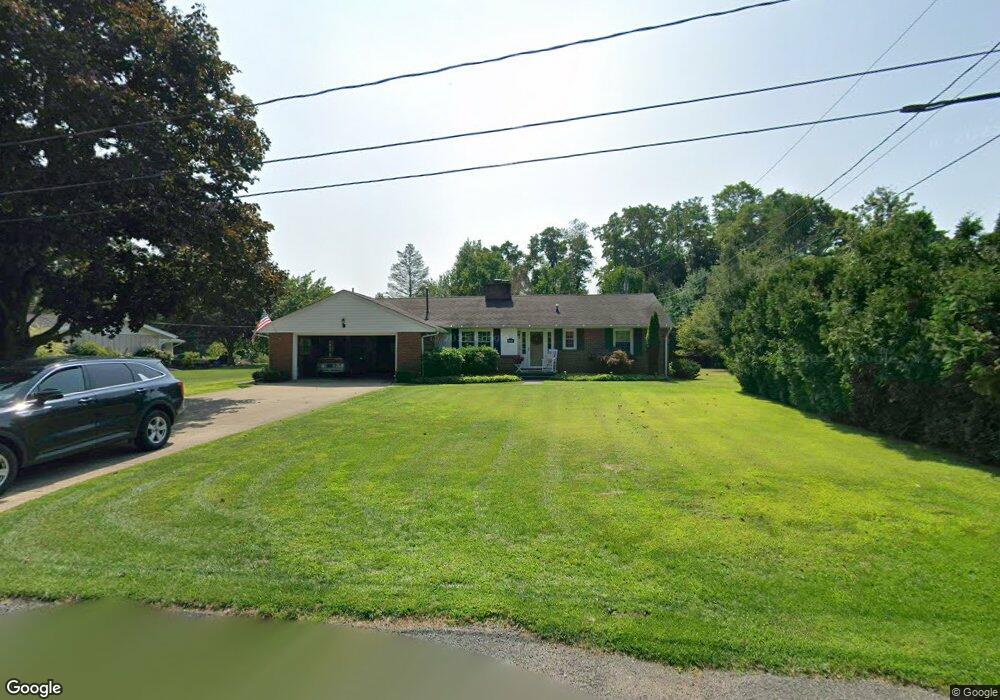
219 Leith Walk Conneaut, OH 44030
Estimated Value: $204,000 - $241,000
3
Beds
3
Baths
1,312
Sq Ft
$171/Sq Ft
Est. Value
About This Home
This home is located at 219 Leith Walk, Conneaut, OH 44030 and is currently estimated at $224,969, approximately $171 per square foot. 219 Leith Walk is a home located in Ashtabula County with nearby schools including Lakeshore Primary Elementary School, Gateway Elementary School, and Conneaut Middle School.
Ownership History
Date
Name
Owned For
Owner Type
Purchase Details
Closed on
Jun 6, 2022
Sold by
Clancy Patrick J and Clancy Cheryl J
Bought by
Clancy Kyle and Clancy Karl
Current Estimated Value
Purchase Details
Closed on
Sep 6, 1995
Sold by
John C Palo Trst
Bought by
Bruce Donald G and Bruce Joan C
Home Financials for this Owner
Home Financials are based on the most recent Mortgage that was taken out on this home.
Original Mortgage
$45,000
Interest Rate
7.76%
Mortgage Type
New Conventional
Create a Home Valuation Report for This Property
The Home Valuation Report is an in-depth analysis detailing your home's value as well as a comparison with similar homes in the area
Home Values in the Area
Average Home Value in this Area
Purchase History
| Date | Buyer | Sale Price | Title Company |
|---|---|---|---|
| Clancy Kyle | $125 | -- | |
| Bruce Donald G | $98,000 | -- |
Source: Public Records
Mortgage History
| Date | Status | Borrower | Loan Amount |
|---|---|---|---|
| Previous Owner | Bruce Donald G | $45,000 |
Source: Public Records
Tax History Compared to Growth
Tax History
| Year | Tax Paid | Tax Assessment Tax Assessment Total Assessment is a certain percentage of the fair market value that is determined by local assessors to be the total taxable value of land and additions on the property. | Land | Improvement |
|---|---|---|---|---|
| 2024 | $4,153 | $56,770 | $8,400 | $48,370 |
| 2023 | $2,681 | $56,770 | $8,400 | $48,370 |
| 2022 | $2,269 | $42,320 | $6,480 | $35,840 |
| 2021 | $2,308 | $42,320 | $6,480 | $35,840 |
| 2020 | $2,307 | $42,320 | $6,480 | $35,840 |
| 2019 | $1,873 | $33,710 | $3,400 | $30,310 |
| 2018 | $1,787 | $33,710 | $3,400 | $30,310 |
| 2017 | $1,784 | $33,710 | $3,400 | $30,310 |
| 2016 | $1,719 | $35,280 | $3,570 | $31,710 |
| 2015 | $1,737 | $35,280 | $3,570 | $31,710 |
| 2014 | $1,537 | $35,280 | $3,570 | $31,710 |
| 2013 | $1,716 | $40,530 | $7,420 | $33,110 |
Source: Public Records
Map
Nearby Homes
- 210 W Main Rd
- 202 W Main Rd Unit 49
- 202 W Main Rd Unit Lot 150
- 202 W Main Rd Unit 33
- 202 W Main Rd Unit 16
- 220 Daniels Ave
- 855 Spring St Unit S9
- 247 Whitney St
- 0 Hillcrest Ct
- 18 Hillcrest Ct
- 40 Oakland Blvd
- VL Center Rd
- 589 Main St
- 2663 Lake Rd
- 1145 Lake Rd
- 57 Eaton Dr
- 536 Madison St
- 1150 Lake Rd
- 474 Sherman St
- 251 St Rt 7
- 211 Leith Walk
- 230 Leith Walk
- 266 Parrish Rd
- 210 Leith Walk
- 262 Parrish Rd
- 181 Leith Walk
- 260 Parrish Rd
- 253 Grifton St
- 263 Townsend Ave
- 249 Grifton St
- 252 Parrish Rd
- 255 Townsend Ave
- 151 Leith Walk
- 250 Parrish Rd
- 259 Parrish Rd
- 245 Grifton St
- 248 Parrish Rd
- 260 Townsend Ave
- 147 Leith Walk
- 246 Parrish Rd