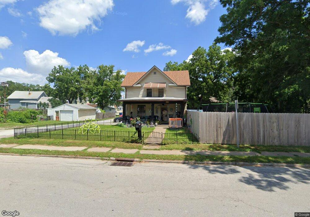
219 S Clark St Davenport, IA 52802
West End NeighborhoodEstimated Value: $124,300 - $132,000
3
Beds
1
Bath
1,730
Sq Ft
$74/Sq Ft
Est. Value
About This Home
This home is located at 219 S Clark St, Davenport, IA 52802 and is currently estimated at $128,575, approximately $74 per square foot. 219 S Clark St is a home located in Scott County with nearby schools including Hayes Elementary School, Frank L. Smart Intermediate School, and West High School.
Ownership History
Date
Name
Owned For
Owner Type
Purchase Details
Closed on
Jun 11, 2013
Sold by
Fifer Gary L
Bought by
First Financial Group Lc
Current Estimated Value
Purchase Details
Closed on
Mar 25, 2011
Sold by
Fifer Gary Lee
Bought by
Fifer Debbie Dawn
Purchase Details
Closed on
Mar 14, 2008
Sold by
Moraetes Michael G and Moraetes Kimberlee
Bought by
Fifer Gary L and Conner Debbie D
Home Financials for this Owner
Home Financials are based on the most recent Mortgage that was taken out on this home.
Original Mortgage
$85,286
Interest Rate
6.17%
Mortgage Type
Purchase Money Mortgage
Create a Home Valuation Report for This Property
The Home Valuation Report is an in-depth analysis detailing your home's value as well as a comparison with similar homes in the area
Home Values in the Area
Average Home Value in this Area
Purchase History
| Date | Buyer | Sale Price | Title Company |
|---|---|---|---|
| First Financial Group Lc | $17,251 | None Available | |
| Fifer Debbie Dawn | -- | None Available | |
| Fifer Gary L | $87,000 | None Available |
Source: Public Records
Mortgage History
| Date | Status | Borrower | Loan Amount |
|---|---|---|---|
| Previous Owner | Fifer Gary L | $85,286 |
Source: Public Records
Tax History Compared to Growth
Tax History
| Year | Tax Paid | Tax Assessment Tax Assessment Total Assessment is a certain percentage of the fair market value that is determined by local assessors to be the total taxable value of land and additions on the property. | Land | Improvement |
|---|---|---|---|---|
| 2024 | $1,902 | $109,020 | $20,730 | $88,290 |
| 2023 | $1,950 | $109,020 | $20,730 | $88,290 |
| 2022 | $1,958 | $91,260 | $20,730 | $70,530 |
| 2021 | $1,958 | $91,260 | $20,730 | $70,530 |
| 2020 | $1,678 | $86,030 | $20,730 | $65,300 |
| 2019 | $1,666 | $82,760 | $20,730 | $62,030 |
| 2018 | $1,626 | $82,760 | $20,730 | $62,030 |
| 2017 | $460 | $82,760 | $20,730 | $62,030 |
| 2016 | $1,622 | $82,760 | $0 | $0 |
| 2015 | $1,622 | $85,420 | $0 | $0 |
| 2014 | $1,704 | $85,420 | $0 | $0 |
| 2013 | $1,670 | $0 | $0 | $0 |
| 2012 | -- | $95,760 | $24,060 | $71,700 |
Source: Public Records
Map
Nearby Homes
- 3003 Telegraph Rd
- 3011 Telegraph Rd
- 3123 Commodore St
- 129 S Birchwood Ave
- 109 S Birchwood Ave
- 2633 Farragut Place
- 2614 Mckinley Ave
- 3400 Telegraph Rd
- 306 S Elmwood Ave
- 3151 Diehn Ave
- 2628 Westwood Place
- 2707 Jackson Ave
- 147 N Thornwood Ave
- 3216 Indian Rd
- 2736 Rockingham Rd
- 815 S Dittmer St
- 2349 W 2nd St
- 2312 W 1st St
- 2312 1/2 W 1st St
- 2502 Rockingham Rd
- 2824 Whitewood Ave
- 2820 Whitewood Ave
- 2825 Telegraph Rd
- 2816 Whitewood Ave
- 2819 Telegraph Rd
- 2814 Whitewood Ave
- 241 S Clark St
- 2809 Telegraph Rd
- 2809 Telegraph Rd Unit 2811
- 2817 Whitewood Ave
- 2808 Whitewood Ave
- 242 S Clark St
- 204 S Rolff St
- 156 S Rolff St
- 2917 Telegraph Rd
- 210 S Rolff St
- 2818 Telegraph Rd
- 2910 Blackhawk St
- 2919 Telegraph Rd
- 2904 Telegraph Rd