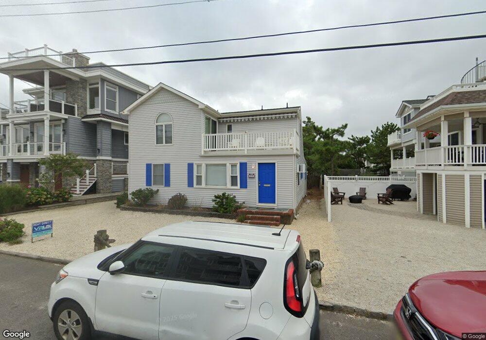
22 10th St Beach Haven, NJ 08008
Long Beach Island NeighborhoodEstimated Value: $1,803,971 - $2,135,000
3
Beds
2
Baths
1,600
Sq Ft
$1,261/Sq Ft
Est. Value
About This Home
This home is located at 22 10th St, Beach Haven, NJ 08008 and is currently estimated at $2,016,993, approximately $1,260 per square foot. 22 10th St is a home located in Ocean County with nearby schools including Beach Haven School, Southern Regional Middle School, and Southern Regional High School.
Ownership History
Date
Name
Owned For
Owner Type
Purchase Details
Closed on
Sep 11, 2018
Sold by
Wohlfarth David W and Wohlfarth Leigh L
Bought by
Kaye Andrew
Current Estimated Value
Purchase Details
Closed on
Aug 30, 2018
Sold by
Bumbaugh David and Bumbaugh Catherine
Bought by
Bumbaugh David
Purchase Details
Closed on
Apr 3, 2014
Sold by
Wohlfarth David W and Wohlfarth Leigh L
Bought by
The David W Wohlfarth Living Trust
Purchase Details
Closed on
Oct 7, 2003
Sold by
Livingston Edward N
Bought by
Wohlfarth David W and Wohlfarth Leigh L
Home Financials for this Owner
Home Financials are based on the most recent Mortgage that was taken out on this home.
Original Mortgage
$25,000
Interest Rate
6.43%
Purchase Details
Closed on
Feb 23, 1996
Sold by
Kamphausen Robert
Bought by
Livingston Edward and Livingston Barbara
Create a Home Valuation Report for This Property
The Home Valuation Report is an in-depth analysis detailing your home's value as well as a comparison with similar homes in the area
Home Values in the Area
Average Home Value in this Area
Purchase History
| Date | Buyer | Sale Price | Title Company |
|---|---|---|---|
| Kaye Andrew | $935,000 | None Available | |
| Bumbaugh David | -- | None Available | |
| The David W Wohlfarth Living Trust | -- | None Available | |
| Wohlfarth David W | $825,000 | -- | |
| Livingston Edward | $222,000 | -- |
Source: Public Records
Mortgage History
| Date | Status | Borrower | Loan Amount |
|---|---|---|---|
| Previous Owner | Wohlfarth David W | $25,000 |
Source: Public Records
Tax History Compared to Growth
Tax History
| Year | Tax Paid | Tax Assessment Tax Assessment Total Assessment is a certain percentage of the fair market value that is determined by local assessors to be the total taxable value of land and additions on the property. | Land | Improvement |
|---|---|---|---|---|
| 2025 | $13,148 | $1,002,100 | $869,300 | $132,800 |
| 2024 | $12,135 | $1,002,100 | $869,300 | $132,800 |
| 2023 | $11,274 | $1,002,100 | $869,300 | $132,800 |
| 2022 | $11,274 | $1,002,100 | $869,300 | $132,800 |
| 2021 | $10,993 | $1,002,100 | $869,300 | $132,800 |
| 2020 | $11,234 | $1,002,100 | $869,300 | $132,800 |
| 2019 | $10,913 | $1,002,100 | $869,300 | $132,800 |
| 2018 | $11,294 | $1,002,100 | $869,300 | $132,800 |
| 2017 | $10,783 | $1,002,100 | $869,300 | $132,800 |
| 2016 | $10,538 | $794,700 | $679,000 | $115,700 |
| 2015 | $10,085 | $794,700 | $679,000 | $115,700 |
| 2014 | $9,536 | $794,700 | $679,000 | $115,700 |
Source: Public Records
Map
Nearby Homes
- 5 9th St
- 10 11th St
- 107 8th St
- 708 N Atlantic Ave
- 221 11th St
- 109 E 14th St
- 1100 N Bay Ave
- 120 E 15th St
- 11 E 13th St
- 218 7th St Unit A
- 1505 N Atlantic Ave
- 222 7th St
- 15 W 13th St Unit U2
- 310 N Atlantic Ave
- 415 N Bay Ave Unit C
- 415 N Bay Ave Unit A
- 415 N Bay Ave Unit B
- 415 N Bay Ave Unit D
- 301 N Beach Ave
- 225 4th St