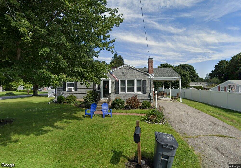
22 Brandywine Rd West Boylston, MA 01583
Estimated Value: $449,828 - $481,000
3
Beds
1
Bath
1,080
Sq Ft
$432/Sq Ft
Est. Value
About This Home
This home is located at 22 Brandywine Rd, West Boylston, MA 01583 and is currently estimated at $466,457, approximately $431 per square foot. 22 Brandywine Rd is a home located in Worcester County with nearby schools including Major Edwards Elementary School, West Boylston Junior/Senior High School, and Abby Kelley Foster Charter Public School.
Ownership History
Date
Name
Owned For
Owner Type
Purchase Details
Closed on
Mar 1, 2017
Sold by
Leipold Angela and Leipold John R
Bought by
Dufault William J and Dufault Trisha M
Current Estimated Value
Home Financials for this Owner
Home Financials are based on the most recent Mortgage that was taken out on this home.
Original Mortgage
$253,900
Outstanding Balance
$210,078
Interest Rate
4.09%
Mortgage Type
VA
Estimated Equity
$256,379
Purchase Details
Closed on
Nov 30, 2009
Sold by
Parker Lt
Bought by
Buttrick Angela
Home Financials for this Owner
Home Financials are based on the most recent Mortgage that was taken out on this home.
Original Mortgage
$130,000
Interest Rate
4.92%
Mortgage Type
Purchase Money Mortgage
Purchase Details
Closed on
May 7, 2004
Sold by
Parker Clarence B
Bought by
Parker Clarence B and Parker Jayne B
Create a Home Valuation Report for This Property
The Home Valuation Report is an in-depth analysis detailing your home's value as well as a comparison with similar homes in the area
Home Values in the Area
Average Home Value in this Area
Purchase History
| Date | Buyer | Sale Price | Title Company |
|---|---|---|---|
| Dufault William J | $253,900 | -- | |
| Buttrick Angela | $211,600 | -- | |
| Parker Lt | -- | -- | |
| Parker Clarence B | -- | -- |
Source: Public Records
Mortgage History
| Date | Status | Borrower | Loan Amount |
|---|---|---|---|
| Open | Dufault William J | $253,900 | |
| Previous Owner | Buttrick Angela | $130,000 |
Source: Public Records
Tax History Compared to Growth
Tax History
| Year | Tax Paid | Tax Assessment Tax Assessment Total Assessment is a certain percentage of the fair market value that is determined by local assessors to be the total taxable value of land and additions on the property. | Land | Improvement |
|---|---|---|---|---|
| 2025 | $52 | $377,600 | $94,300 | $283,300 |
| 2024 | $5,152 | $348,600 | $94,300 | $254,300 |
| 2023 | $5,078 | $325,900 | $93,700 | $232,200 |
| 2022 | $4,805 | $271,800 | $93,700 | $178,100 |
| 2021 | $4,667 | $252,800 | $89,900 | $162,900 |
| 2020 | $4,578 | $246,400 | $89,900 | $156,500 |
| 2019 | $4,303 | $228,300 | $89,900 | $138,400 |
| 2018 | $4,115 | $219,800 | $89,900 | $129,900 |
| 2017 | $3,679 | $195,700 | $89,900 | $105,800 |
| 2016 | $3,589 | $194,500 | $83,700 | $110,800 |
| 2015 | $3,402 | $185,500 | $82,800 | $102,700 |
Source: Public Records
Map
Nearby Homes
- 1 Highland Ave
- 39 Davidson Rd
- 62 Maple St
- 54 Maple St
- 12 Birchbrush Ln
- 152 Worcester St Unit 8
- 740 Burncoat St Unit B
- 33 Meola Ave
- 39 Meola Ave
- 156 Hillside Village Dr
- 33 Isleboro St
- 156 Prospect St
- 29 Isleboro St
- 1110 W Boylston St Unit A
- 1097 W Boylston St
- 83 Hillside Village Dr
- 97 Hillside Village Dr
- 59 Santoro Rd
- 44 Dixfield St
- 64 Worcester St
- 18 Brandywine Rd
- 31 Bunkerhill Pkwy
- 42 Bunkerhill Pkwy
- 23 Brandywine Rd
- 46 Bunkerhill Pkwy
- 27 Bunkerhill Pkwy
- 19 Brandywine Rd
- 38 Bunkerhill Pkwy
- 14 Brandywine Rd
- 15 Brandywine Rd
- 50 Bunkerhill Pkwy
- 34 Bunkerhill Pkwy
- 323 Worcester St
- 23 Bunkerhill Pkwy
- 325 Worcester St
- 30 Bunkerhill Pkwy
- 51 Bunkerhill Pkwy
- 12 Brandywine Rd
- 321 Worcester St
- 26 Bunkerhill Pkwy