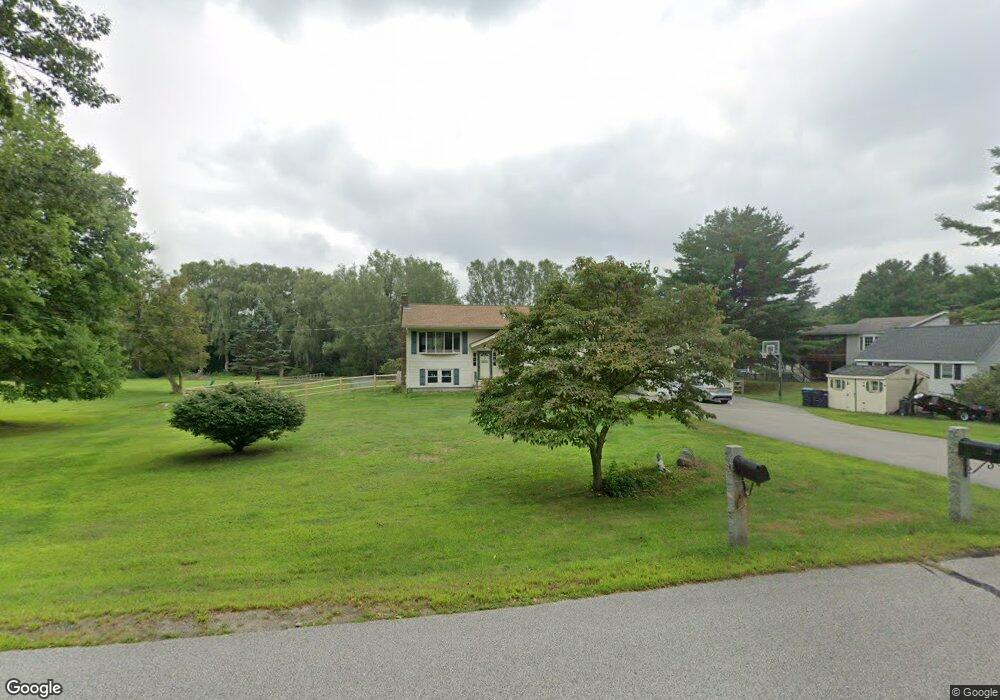
22 High St Stratham, NH 03885
Estimated Value: $579,000 - $655,000
3
Beds
2
Baths
1,581
Sq Ft
$388/Sq Ft
Est. Value
About This Home
This home is located at 22 High St, Stratham, NH 03885 and is currently estimated at $612,655, approximately $387 per square foot. 22 High St is a home located in Rockingham County with nearby schools including Stratham Memorial School, Cooperative Middle School, and Exeter High School.
Ownership History
Date
Name
Owned For
Owner Type
Purchase Details
Closed on
May 2, 2019
Sold by
Donna M Buxton Ret and Buxton
Bought by
Hovanec Kathleen
Current Estimated Value
Purchase Details
Closed on
May 3, 2012
Sold by
Ingoldsby Mark E and Ingoldsby Carol A
Bought by
Newkirk Brett W and Hart-Newkirk Tanya L
Create a Home Valuation Report for This Property
The Home Valuation Report is an in-depth analysis detailing your home's value as well as a comparison with similar homes in the area
Home Values in the Area
Average Home Value in this Area
Purchase History
| Date | Buyer | Sale Price | Title Company |
|---|---|---|---|
| Hovanec Kathleen | $184,933 | -- | |
| Hovanec Kathleen | $184,933 | -- | |
| Newkirk Brett W | $255,000 | -- | |
| Newkirk Brett W | $255,000 | -- |
Source: Public Records
Mortgage History
| Date | Status | Borrower | Loan Amount |
|---|---|---|---|
| Previous Owner | Newkirk Brett W | $85,250 | |
| Closed | Newkirk Brett W | $0 |
Source: Public Records
Tax History
| Year | Tax Paid | Tax Assessment Tax Assessment Total Assessment is a certain percentage of the fair market value that is determined by local assessors to be the total taxable value of land and additions on the property. | Land | Improvement |
|---|---|---|---|---|
| 2025 | $8,001 | $591,800 | $341,300 | $250,500 |
| 2024 | $7,764 | $591,800 | $341,300 | $250,500 |
| 2023 | $7,427 | $355,200 | $175,700 | $179,500 |
| 2022 | $6,646 | $355,200 | $175,700 | $179,500 |
| 2021 | $6,458 | $348,700 | $175,700 | $173,000 |
| 2020 | $6,340 | $348,700 | $175,700 | $173,000 |
| 2019 | $6,496 | $348,700 | $175,700 | $173,000 |
| 2018 | $5,933 | $282,500 | $130,700 | $151,800 |
| 2017 | $5,735 | $282,500 | $130,700 | $151,800 |
| 2016 | $5,322 | $282,500 | $130,700 | $151,800 |
| 2015 | $5,622 | $282,500 | $130,700 | $151,800 |
| 2014 | $5,625 | $282,500 | $130,700 | $151,800 |
| 2013 | $5,551 | $282,500 | $130,700 | $151,800 |
Source: Public Records
Map
Nearby Homes
- 00 Scamman Rd
- 3 Chisholm Farm Dr
- 00 Lovell Rd Unit 22
- 14 Lovell Rd
- 40 Stratham Green
- 14 Balmoral Dr
- 177 Winnicutt Rd
- 44 Glengarry Dr
- 107 Glengarry Dr
- 13 Dearborn Rd
- 74 College Rd
- 141 Dearborn Rd
- 24 Great Bay Rd
- 21 Parkman Brook Ln
- 8 Montrose Dr
- 35 Montrose Dr
- 85 College Rd
- 10 Wingate Ct
- 8 Winterberry Ln
- Homesite 2 Windsong Place