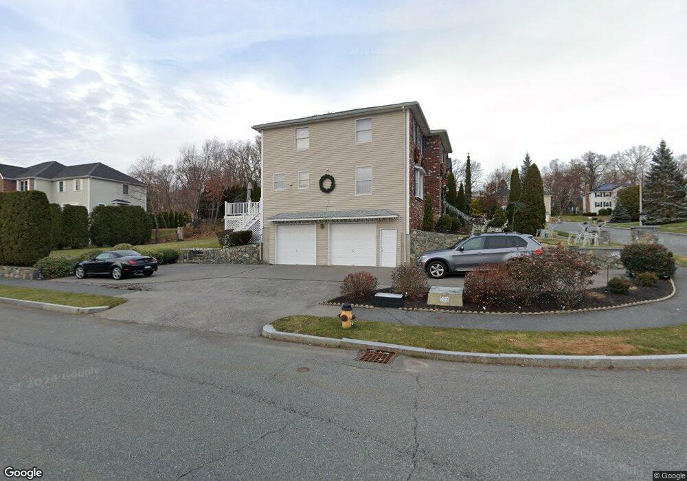
22 Raffaele Dr Waltham, MA 02452
North Waltham NeighborhoodEstimated Value: $1,467,000 - $1,543,624
4
Beds
3
Baths
3,146
Sq Ft
$480/Sq Ft
Est. Value
About This Home
This home is located at 22 Raffaele Dr, Waltham, MA 02452 and is currently estimated at $1,509,156, approximately $479 per square foot. 22 Raffaele Dr is a home located in Middlesex County with nearby schools including Northeast Elementary School, John F Kennedy Middle School, and Waltham Sr High School.
Ownership History
Date
Name
Owned For
Owner Type
Purchase Details
Closed on
Jun 23, 2005
Sold by
Poon Edward K and Poon Henry K
Bought by
Idanjian Antranic K
Current Estimated Value
Purchase Details
Closed on
Jun 12, 1992
Sold by
Pigeon Hill Est T
Bought by
Amelia Bldg Corp
Create a Home Valuation Report for This Property
The Home Valuation Report is an in-depth analysis detailing your home's value as well as a comparison with similar homes in the area
Home Values in the Area
Average Home Value in this Area
Purchase History
| Date | Buyer | Sale Price | Title Company |
|---|---|---|---|
| Idanjian Antranic K | $865,000 | -- | |
| Amelia Bldg Corp | $82,500 | -- |
Source: Public Records
Mortgage History
| Date | Status | Borrower | Loan Amount |
|---|---|---|---|
| Open | Amelia Bldg Corp | $100,000 | |
| Open | Amelia Bldg Corp | $523,750 | |
| Closed | Amelia Bldg Corp | $120,000 |
Source: Public Records
Tax History
| Year | Tax Paid | Tax Assessment Tax Assessment Total Assessment is a certain percentage of the fair market value that is determined by local assessors to be the total taxable value of land and additions on the property. | Land | Improvement |
|---|---|---|---|---|
| 2025 | $13,346 | $1,359,100 | $483,200 | $875,900 |
| 2024 | $12,806 | $1,328,400 | $461,800 | $866,600 |
| 2023 | $12,703 | $1,230,900 | $419,100 | $811,800 |
| 2022 | $13,268 | $1,191,000 | $419,100 | $771,900 |
| 2021 | $12,955 | $1,144,400 | $402,000 | $742,400 |
| 2020 | $12,977 | $1,085,900 | $376,300 | $709,600 |
| 2019 | $12,088 | $954,800 | $369,500 | $585,300 |
| 2018 | $10,911 | $865,300 | $342,100 | $523,200 |
| 2017 | $10,278 | $818,300 | $295,100 | $523,200 |
| 2016 | $9,754 | $796,900 | $273,700 | $523,200 |
| 2015 | $10,001 | $761,700 | $269,400 | $492,300 |
Source: Public Records
Map
Nearby Homes
- 345 Bishops Forest Dr
- 170 Clocktower Dr Unit 103
- 86 Indian Rd
- 501 Lexington St Unit 11
- 203 College Farm Rd
- 1105 Lexington St Unit 6-4
- 12 Curve St
- 49 Lincoln St
- 28 Hillcrest St
- 89 Hardy Pond Rd
- 16 Winter St Unit 26C
- 44 Lakeview Terrace
- 21 Lakeview Ave
- 50 Worcester Ln
- 100 Shirley Rd
- 8 Dobbins St
- 353 Concord Ave
- 15 Cedarcroft Ln
- 9 April Ln Unit 9
- 11 Autumn Ln
Your Personal Tour Guide
Ask me questions while you tour the home.