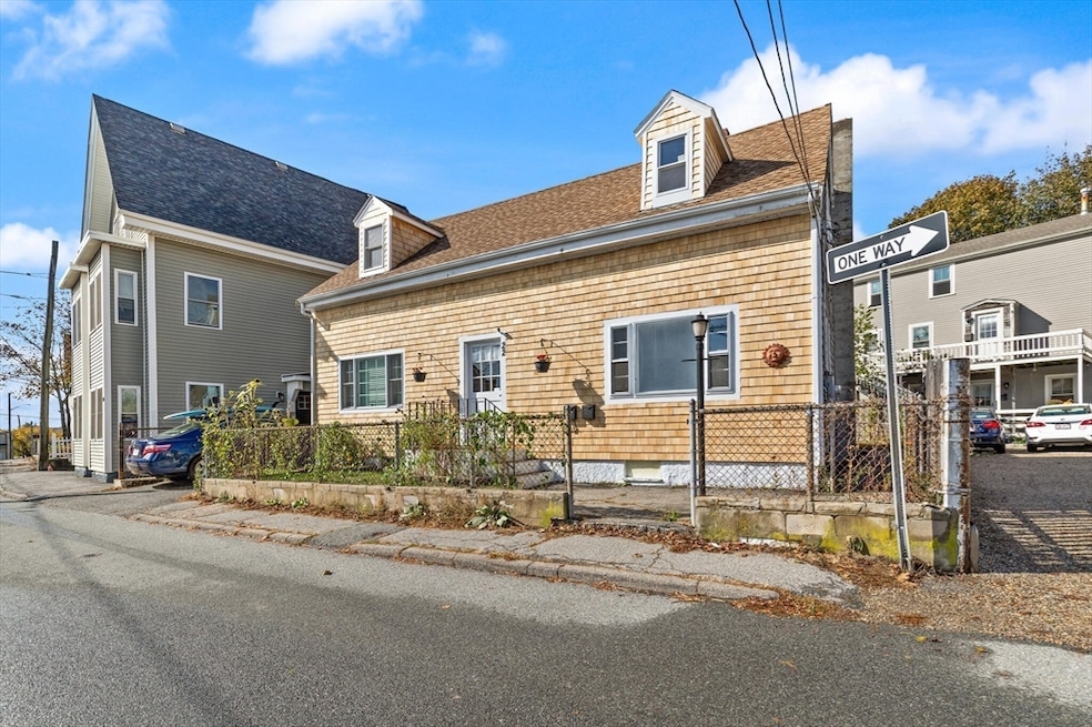
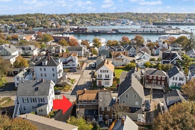
22 Taylor St Unit 1 Gloucester, MA 01930
Central Gloucester NeighborhoodEstimated payment $1,754/month
Highlights
- Very Popular Property
- End Unit
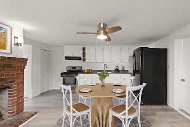
- Dining Area
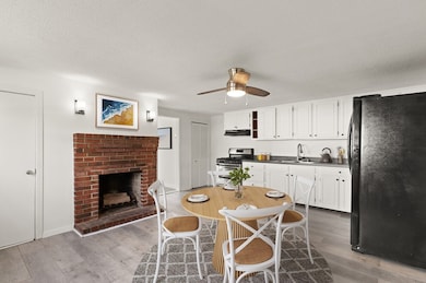
- 1 Fireplace
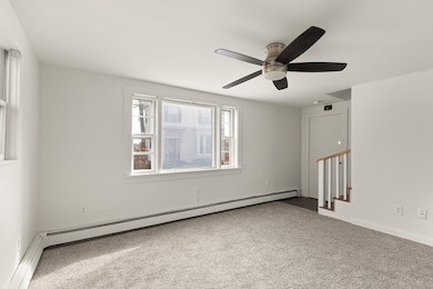
- Baseboard Heating
- Wall to Wall Carpet
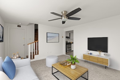
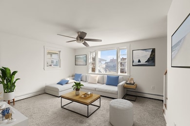
About This Home
Don’t miss this rare opportunity to own in Gloucester! This well-maintained townhouse-style condo features a spacious eat-in kitchen, bright living room, and two generous bedrooms with ample closet space. The full bath includes in-unit laundry for added convenience. The lower level offers a full basement providing excellent storage. Freshly painted with new flooring, plus recent exterior updates including new front siding. Located in a desirable neighborhood close to Good Harbor Beach, shopping, and major routes. Income and asset restrictions apply. DEED RESTRICTED AFFORDABLE SALE.
Townhouse Details
Home Type
- Townhome
Est. Annual Taxes
- $2,641
Year Built
- Built in 1900
Lot Details
- End Unit
Home Design
- Entry on the 1st floor
- Shingle Roof
Interior Spaces
- 864 Sq Ft Home
- 1-Story Property
- 1 Fireplace
- Dining Area
- Range
- Laundry on main level
- Basement
Flooring
- Wall to Wall Carpet
- Laminate
Bedrooms and Bathrooms
- 2 Bedrooms
- Primary bedroom located on second floor
- 1 Full Bathroom
Utilities
- No Cooling
- Heating System Uses Oil
- Baseboard Heating
Community Details
- 2 Units
Listing and Financial Details
- Assessor Parcel Number M:0030 B:0025 L:0001,1895300
Map
Home Values in the Area
Average Home Value in this Area
Tax History
| Year | Tax Paid | Tax Assessment Tax Assessment Total Assessment is a certain percentage of the fair market value that is determined by local assessors to be the total taxable value of land and additions on the property. | Land | Improvement |
|---|---|---|---|---|
| 2025 | $2,641 | $271,700 | $0 | $271,700 |
| 2024 | $2,504 | $257,300 | $0 | $257,300 |
| 2023 | $2,225 | $210,100 | $0 | $210,100 |
| 2022 | $2,094 | $178,500 | $0 | $178,500 |
| 2021 | $2,219 | $178,400 | $0 | $178,400 |
| 2020 | $2,200 | $178,400 | $0 | $178,400 |
| 2019 | $2,217 | $174,700 | $0 | $174,700 |
| 2018 | $2,163 | $167,300 | $0 | $167,300 |
| 2017 | $2,203 | $167,000 | $0 | $167,000 |
| 2016 | $2,218 | $163,000 | $0 | $163,000 |
| 2015 | $2,179 | $159,600 | $0 | $159,600 |
Property History
| Date | Event | Price | List to Sale | Price per Sq Ft |
|---|---|---|---|---|
| 11/12/2025 11/12/25 | Pending | -- | -- | -- |
| 10/24/2025 10/24/25 | For Sale | $291,000 | -- | $337 / Sq Ft |
Purchase History
| Date | Type | Sale Price | Title Company |
|---|---|---|---|
| Deed | -- | -- | |
| Deed | $80,000 | -- | |
| Deed | $65,000 | -- |
Mortgage History
| Date | Status | Loan Amount | Loan Type |
|---|---|---|---|
| Previous Owner | $60,000 | Purchase Money Mortgage | |
| Previous Owner | $68,000 | Purchase Money Mortgage |
Source: MLS Property Information Network (MLS PIN)
MLS Number: 73447463
APN: GLOU-000030-000025-000001
Disclaimer: Certain information contained herein is derived from information provided by parties other than Homes.com. All information provided is deemed reliable, but is not guaranteed to be accurate and should be independently verified.
![]() The property listing data and information, or the Images, set forth herein were provided to MLS Property Information Network, Inc. from third party sources, including sellers, lessors and public records, and were compiled by MLS Property Information Network, Inc. The property listing data and information, and the Images, are for the personal, non-commercial use of consumers having a good faith interest in purchasing or leasing listed properties of the type displayed to them and may not be used for any purpose other than to identify prospective properties which such consumers may have a good faith interest in purchasing or leasing. MLS Property Information Network, Inc. and its subscribers disclaim any and all representations and warranties as to the accuracy of the property listing data and information, or as to the accuracy of any of the Images, set forth herein.
The property listing data and information, or the Images, set forth herein were provided to MLS Property Information Network, Inc. from third party sources, including sellers, lessors and public records, and were compiled by MLS Property Information Network, Inc. The property listing data and information, and the Images, are for the personal, non-commercial use of consumers having a good faith interest in purchasing or leasing listed properties of the type displayed to them and may not be used for any purpose other than to identify prospective properties which such consumers may have a good faith interest in purchasing or leasing. MLS Property Information Network, Inc. and its subscribers disclaim any and all representations and warranties as to the accuracy of the property listing data and information, or as to the accuracy of any of the Images, set forth herein.
- 160 Prospect St Unit 3
- 52 Taylor St
- 6 Prospect Ct
- 119 Pleasant St
- 40 Sargent St
- 191 Main St Unit 2B
- 191 Main St Unit 3
- 191 Main St Unit 2A
- 90 Middle St Unit L
- 97 E Main St
- 86 E Main St
- 29 Harrison Ave
- 100 E Main St
- 197 E Main St
- 197 E Main St Unit 1 & 2
- 78 Grove St
- 9 Rocky Pasture Rd
- 33 Middle St
- 40 Middle St Unit 2
- 30 Chapel St Unit B
