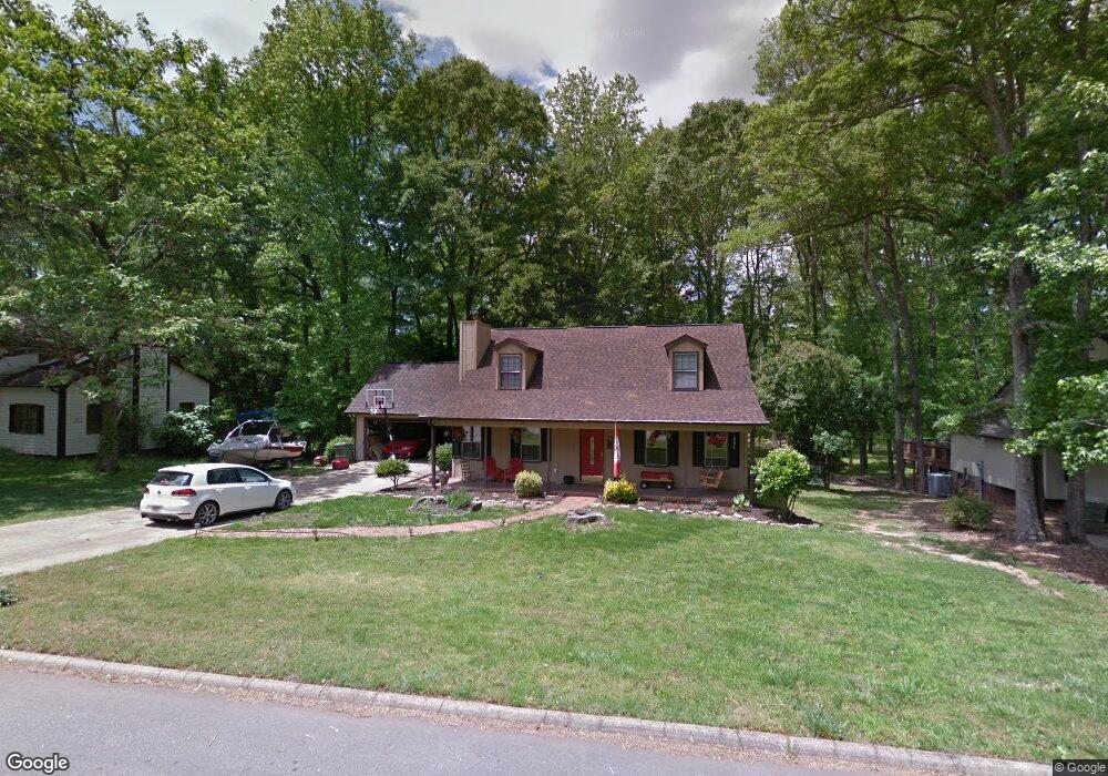
220 Anders Ave Mauldin, SC 29662
Estimated Value: $332,000 - $358,000
4
Beds
2
Baths
2,100
Sq Ft
$164/Sq Ft
Est. Value
About This Home
This home is located at 220 Anders Ave, Mauldin, SC 29662 and is currently estimated at $344,667, approximately $164 per square foot. 220 Anders Ave is a home located in Greenville County with nearby schools including Mauldin Elementary School, Dr. Phinnize J. Fisher Middle, and Mauldin High School.
Ownership History
Date
Name
Owned For
Owner Type
Purchase Details
Closed on
Nov 14, 2014
Sold by
Shepherd Paul C
Bought by
Lineberry Jeffrey K
Current Estimated Value
Purchase Details
Closed on
Oct 30, 2012
Sold by
Mccordic Dawn and Barlage Dawn E
Bought by
Shepherd Ii Paul C
Home Financials for this Owner
Home Financials are based on the most recent Mortgage that was taken out on this home.
Original Mortgage
$127,645
Interest Rate
3.37%
Mortgage Type
FHA
Create a Home Valuation Report for This Property
The Home Valuation Report is an in-depth analysis detailing your home's value as well as a comparison with similar homes in the area
Home Values in the Area
Average Home Value in this Area
Purchase History
| Date | Buyer | Sale Price | Title Company |
|---|---|---|---|
| Lineberry Jeffrey K | $158,000 | -- | |
| Shepherd Ii Paul C | $130,000 | -- |
Source: Public Records
Mortgage History
| Date | Status | Borrower | Loan Amount |
|---|---|---|---|
| Previous Owner | Shepherd Ii Paul C | $127,645 |
Source: Public Records
Tax History
| Year | Tax Paid | Tax Assessment Tax Assessment Total Assessment is a certain percentage of the fair market value that is determined by local assessors to be the total taxable value of land and additions on the property. | Land | Improvement |
|---|---|---|---|---|
| 2025 | $1,585 | $9,590 | $2,140 | $7,450 |
| 2024 | $1,585 | $8,340 | $1,240 | $7,100 |
| 2023 | $1,519 | $8,340 | $1,240 | $7,100 |
| 2022 | $1,431 | $8,340 | $1,240 | $7,100 |
| 2021 | $1,432 | $8,340 | $1,240 | $7,100 |
| 2020 | $1,317 | $7,250 | $1,080 | $6,170 |
| 2019 | $1,318 | $7,250 | $1,080 | $6,170 |
| 2018 | $1,315 | $7,250 | $1,080 | $6,170 |
| 2017 | $3,473 | $10,880 | $1,620 | $9,260 |
| 2016 | $3,383 | $181,310 | $27,000 | $154,310 |
| 2015 | $3,383 | $181,310 | $27,000 | $154,310 |
| 2014 | $3,225 | $174,914 | $24,902 | $150,012 |
Source: Public Records
Map
Nearby Homes
- 6 Timberfalls Dr
- 105 Timber Falls Dr
- 120 Timber Falls Dr
- 107 Timber Falls Dr
- 502 Serena Trail
- 403 Mariene Dr
- 107 Gail Dr
- 505 Serena Trail
- 524 Winding Meadow Ln
- 314 Highline Trail
- 111 Norse Creek Dr
- 311 Highline Trail
- 109 Cedar Oak Ln
- 1 Apollo View Ln
- 17 Apollo View Ln
- 516 Serena Trail
- 310 Laurel Park Dr
- 308 Blaine Ct
- 109 Muirwood Dr
- 11 Pikewood Ln
Your Personal Tour Guide
Ask me questions while you tour the home.