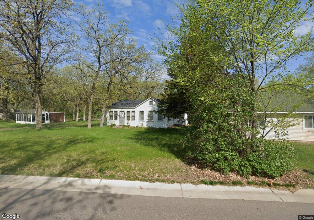
220 Euclid Ave Big Lake, MN 55309
Estimated Value: $141,801 - $316,000
2
Beds
1
Bath
898
Sq Ft
$245/Sq Ft
Est. Value
About This Home
This home is located at 220 Euclid Ave, Big Lake, MN 55309 and is currently estimated at $219,700, approximately $244 per square foot. 220 Euclid Ave is a home located in Sherburne County with nearby schools including Liberty Elementary School, Independence Elementary School, and Big Lake Middle School.
Ownership History
Date
Name
Owned For
Owner Type
Purchase Details
Closed on
May 3, 2024
Sold by
Wigren Shirley M
Bought by
Shirley M Wigren Living Trust and Wilcox
Current Estimated Value
Purchase Details
Closed on
Sep 14, 2023
Sold by
Wigren Frieda Bertha Rose
Bought by
Wigren Melanie
Purchase Details
Closed on
Aug 11, 2023
Sold by
Wigren John M
Bought by
Wigren Melanie
Purchase Details
Closed on
Oct 22, 2018
Sold by
Wigren Shirley M
Bought by
Wigren Shirley M
Create a Home Valuation Report for This Property
The Home Valuation Report is an in-depth analysis detailing your home's value as well as a comparison with similar homes in the area
Home Values in the Area
Average Home Value in this Area
Purchase History
| Date | Buyer | Sale Price | Title Company |
|---|---|---|---|
| Shirley M Wigren Living Trust | $500 | None Listed On Document | |
| Wigren Melanie | -- | -- | |
| Wigren Melanie | -- | None Listed On Document | |
| Wigren Shirley M | -- | None Available |
Source: Public Records
Tax History Compared to Growth
Tax History
| Year | Tax Paid | Tax Assessment Tax Assessment Total Assessment is a certain percentage of the fair market value that is determined by local assessors to be the total taxable value of land and additions on the property. | Land | Improvement |
|---|---|---|---|---|
| 2025 | $880 | $58,300 | $31,900 | $26,400 |
| 2024 | $1,012 | $55,800 | $31,900 | $23,900 |
| 2023 | $994 | $70,000 | $45,100 | $24,900 |
| 2022 | $648 | $63,600 | $37,600 | $26,000 |
| 2020 | $612 | $44,700 | $20,800 | $23,900 |
| 2019 | $470 | $41,700 | $18,700 | $23,000 |
| 2018 | $462 | $31,100 | $8,400 | $22,700 |
| 2017 | $456 | $29,200 | $7,500 | $21,700 |
| 2016 | $472 | $27,900 | $7,100 | $20,800 |
| 2015 | $466 | $29,000 | $8,400 | $20,600 |
| 2014 | $578 | $28,700 | $8,400 | $20,300 |
| 2013 | -- | $33,200 | $8,300 | $24,900 |
Source: Public Records
Map
Nearby Homes
- 491 Highland Ave
- 679 Lakeshore Dr
- 241 Leighton Dr
- TBD Highway 10 NW
- 20050 County Road 81 NW
- 20311 Gordon Ln
- TBD Manitou St
- 3300 Lake View Ln
- 240 Wyoming Ave
- 100 Park Ave
- 637 Norwood Ln
- 4637 Pond View Cir
- 5008 Bluff Rd
- 4265 Lake Ridge Dr
- 3250 Lake Ridge Dr
- 20189 Esther Pkwy
- 20172 Truman Dr
- 110 Powell Cir E
- 874 Independence Dr NW
- 1075 Kilbirnie Rd
- 210 Euclid Ave
- 301 Lakeshore Dr
- 321 Lakeshore Dr
- 337 Lake Ave
- 311 Lake Ave
- 211 Euclid Ave
- 260 Euclid Ave
- 231 Euclid Ave
- 341 Lakeshore Dr
- 291 Lakeshore Dr
- 241 Euclid Ave
- 361 Lakeshore Dr
- 341 Lake Ave
- 281 Lakeshore Dr
- 251 Euclid Ave
- 381 Lakeshore Dr
- 271 Euclid Ave
- 381 Lake Ave
- 280 Euclid Ave
- 280 Euclid Ave