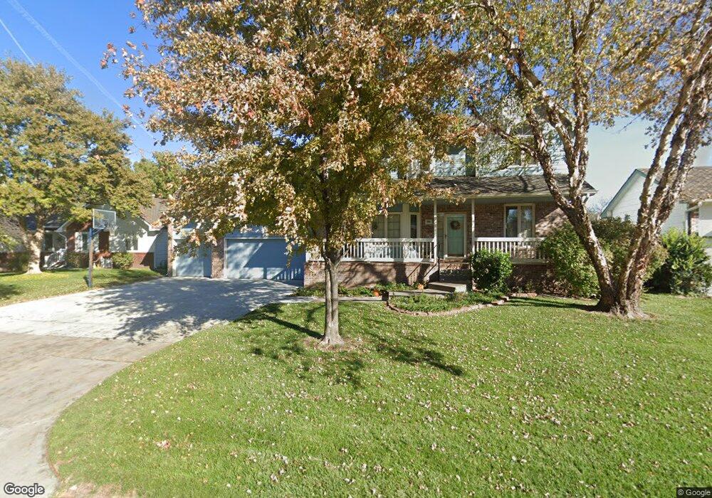
220 N Prescott Cir Wichita, KS 67212
Far West Wichita NeighborhoodEstimated Value: $324,000 - $338,159
4
Beds
3
Baths
2,213
Sq Ft
$150/Sq Ft
Est. Value
About This Home
This home is located at 220 N Prescott Cir, Wichita, KS 67212 and is currently estimated at $331,080, approximately $149 per square foot. 220 N Prescott Cir is a home located in Sedgwick County with nearby schools including Peterson Elementary School, Wilbur Middle School, and Wichita Northwest High School.
Ownership History
Date
Name
Owned For
Owner Type
Purchase Details
Closed on
May 30, 2024
Sold by
Barbara J Johnson Revocable Trust and Johnson Jay A
Bought by
Jay A Johnson Family Trust and Barbara J Johnson Revocable Trust
Current Estimated Value
Purchase Details
Closed on
Mar 6, 2015
Sold by
Johnsons General Stores Inc
Bought by
Jay A Johnson & Barbara J Johnson Family
Create a Home Valuation Report for This Property
The Home Valuation Report is an in-depth analysis detailing your home's value as well as a comparison with similar homes in the area
Home Values in the Area
Average Home Value in this Area
Purchase History
| Date | Buyer | Sale Price | Title Company |
|---|---|---|---|
| Jay A Johnson Family Trust | -- | None Listed On Document | |
| Barbara J Johnson Revocable Trust | -- | None Listed On Document | |
| Jay A Johnson & Barbara J Johnson Family | -- | Security 1St Title |
Source: Public Records
Tax History Compared to Growth
Tax History
| Year | Tax Paid | Tax Assessment Tax Assessment Total Assessment is a certain percentage of the fair market value that is determined by local assessors to be the total taxable value of land and additions on the property. | Land | Improvement |
|---|---|---|---|---|
| 2025 | $3,576 | $34,351 | $7,464 | $26,887 |
| 2023 | $3,576 | $29,475 | $6,084 | $23,391 |
| 2022 | $3,309 | $29,475 | $5,739 | $23,736 |
| 2021 | $3,131 | $27,290 | $3,439 | $23,851 |
| 2020 | $2,964 | $25,749 | $3,439 | $22,310 |
| 2019 | $2,825 | $24,519 | $3,439 | $21,080 |
| 2018 | $2,723 | $23,575 | $3,381 | $20,194 |
| 2017 | $2,594 | $0 | $0 | $0 |
| 2016 | $2,591 | $0 | $0 | $0 |
| 2015 | $2,607 | $0 | $0 | $0 |
| 2014 | $2,634 | $0 | $0 | $0 |
Source: Public Records
Map
Nearby Homes
- 11112 W Rolling Hills Dr
- 110 N Prescott St
- 11508 W Douglas Ave
- 410 N David St
- 209 N Milstead St
- 238 N Mesa St
- 236 S Parkridge St
- 11005 W Taylor Cir
- 11218 W Taylor St
- 12018 Meribeau Ct
- 373 S Covington St
- 126 S Coach House Rd
- 11110 W Central Ave
- 12400 W Jayson Ln
- 12521 W Hardtner Ct
- 810 N Parkridge St
- 522 N Bay Country St
- 12514 W Hardtner St
- 313 N Jaax St
- 12505 W Binter St
- 224 N Prescott Cir
- 216 N Prescott Cir
- 228 N Prescott Cir
- 221 N Prescott Cir
- 11050 W 1st Ct N
- 11046 W 1st Ct N
- 225 N Prescott Cir
- 212 N Prescott Cir
- 217 N Prescott Cir
- 229 N Prescott Cir
- 11054 W 1st Ct N
- 11062 W 1st St N
- 213 N Prescott Cir
- 11042 W 1st Ct N
- 232 N Prescott Cir
- 233 N Prescott Cir
- 11058 W 1st Ct N
- 11038 W 1st Ct N
- 236 N Prescott Cir
- 216 N Shefford St