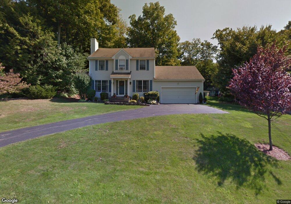
220 Upper Valley Rd Torrington, CT 06790
Estimated Value: $337,000 - $403,000
3
Beds
2
Baths
1,456
Sq Ft
$252/Sq Ft
Est. Value
About This Home
This home is located at 220 Upper Valley Rd, Torrington, CT 06790 and is currently estimated at $366,856, approximately $251 per square foot. 220 Upper Valley Rd is a home located in Litchfield County with nearby schools including Torrington Middle School, Torrington High School, and Torrington Christian Academy.
Ownership History
Date
Name
Owned For
Owner Type
Purchase Details
Closed on
May 11, 2019
Sold by
Vanotti Joseph D and Vanotti Michelle L
Bought by
Vanotti Joseph D and Vanotti Michelle L
Current Estimated Value
Home Financials for this Owner
Home Financials are based on the most recent Mortgage that was taken out on this home.
Original Mortgage
$164,000
Outstanding Balance
$143,896
Interest Rate
4.1%
Mortgage Type
FHA
Estimated Equity
$222,960
Purchase Details
Closed on
Mar 10, 1998
Sold by
Citizens Bk Of Conn
Bought by
Vanotti Joseph D and Vanotti Michelle L
Purchase Details
Closed on
Jun 2, 1992
Sold by
Alan Temkin Assoc Inc
Bought by
Lussier Ronald A and Lussier Patricia
Create a Home Valuation Report for This Property
The Home Valuation Report is an in-depth analysis detailing your home's value as well as a comparison with similar homes in the area
Home Values in the Area
Average Home Value in this Area
Purchase History
| Date | Buyer | Sale Price | Title Company |
|---|---|---|---|
| Vanotti Joseph D | -- | -- | |
| Vanotti Joseph D | $119,000 | -- | |
| Lussier Ronald A | $165,421 | -- |
Source: Public Records
Mortgage History
| Date | Status | Borrower | Loan Amount |
|---|---|---|---|
| Open | Vanotti Joseph D | $164,000 | |
| Previous Owner | Lussier Ronald A | $131,200 | |
| Previous Owner | Lussier Ronald A | $97,900 | |
| Previous Owner | Lussier Ronald A | $25,000 |
Source: Public Records
Tax History
| Year | Tax Paid | Tax Assessment Tax Assessment Total Assessment is a certain percentage of the fair market value that is determined by local assessors to be the total taxable value of land and additions on the property. | Land | Improvement |
|---|---|---|---|---|
| 2025 | $7,587 | $197,330 | $31,500 | $165,830 |
| 2024 | $5,466 | $113,950 | $31,500 | $82,450 |
| 2023 | $5,465 | $113,950 | $31,500 | $82,450 |
| 2022 | $5,372 | $113,950 | $31,500 | $82,450 |
| 2021 | $5,261 | $113,950 | $31,500 | $82,450 |
| 2020 | $5,261 | $113,950 | $31,500 | $82,450 |
| 2019 | $6,089 | $131,890 | $45,500 | $86,390 |
| 2018 | $5,704 | $123,540 | $45,500 | $78,040 |
| 2017 | $6,034 | $131,890 | $45,500 | $86,390 |
| 2016 | $5,652 | $123,540 | $45,500 | $78,040 |
| 2015 | $5,652 | $123,540 | $45,500 | $78,040 |
| 2014 | $5,799 | $159,670 | $71,300 | $88,370 |
Source: Public Records
Map
Nearby Homes
- KENNEDY DRIVE & Torringford St
- 119 Auburn Way
- 353A Hayden Hill Rd
- 2200 Torringford West St
- 172 Hillandale Blvd
- 230 White Oak Way
- 19 Marshall St
- 3222 Torringford St
- 646 Torringford St
- 2951 Winsted Rd
- 94 Colin Dr
- 1683 Torringford St
- 0 Torringford West St
- 1229 Winsted Rd Unit 57
- 1229 Winsted Rd Unit 93
- 1229 Winsted Rd Unit 116
- 302 Gillette Rd
- 91 Rockledge Loop
- 9 Hemlock Dr
- 144 Spyglass Ct
- 230 Upper Valley Rd
- 214 Upper Valley Rd
- 202 Upper Valley Rd
- 219 Upper Valley Rd
- 193 Upper Valley Rd
- 246 Upper Valley Rd
- 210 Upper Valley Rd
- 190 Upper Valley Rd
- 310 Upper Valley Rd
- 243 Upper Valley Rd
- 180 Upper Valley Rd
- 35 Quail Run
- 284 Upper Valley Rd
- 205 Tall Tree Ln
- 17 Quail Run
- 171 Upper Valley Rd
- 45 Quail Run
- 263 Upper Valley Rd
- 166 Upper Valley Rd
- 189 Tall Tree Ln
Your Personal Tour Guide
Ask me questions while you tour the home.