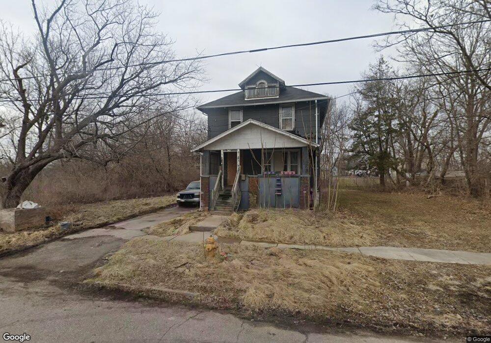
220 W 13th St Flint, MI 48503
South Parks NeighborhoodEstimated Value: $34,000 - $58,000
3
Beds
1
Bath
1,144
Sq Ft
$40/Sq Ft
Est. Value
About This Home
This home is located at 220 W 13th St, Flint, MI 48503 and is currently estimated at $46,000, approximately $40 per square foot. 220 W 13th St is a home located in Genesee County with nearby schools including Freeman Elementary School, Flint Southwestern Classical Academy, and Flint Cultural Center Academy.
Ownership History
Date
Name
Owned For
Owner Type
Purchase Details
Closed on
Dec 19, 2019
Sold by
Genesee County Treasurer
Bought by
Genesee County Land Bank Authority
Current Estimated Value
Purchase Details
Closed on
Nov 6, 2018
Sold by
Jones Nancy
Bought by
Muyir Mohammed
Purchase Details
Closed on
Aug 1, 2002
Sold by
Thompson Chester J and Thompson Marycatherine A
Bought by
Jones Nancy Ann
Purchase Details
Closed on
Mar 28, 2002
Sold by
Newton Angela
Bought by
Thompson Chester and Thompson Marycatherine A
Purchase Details
Closed on
Mar 6, 2002
Sold by
Wachowski Steven and Wachowski Janet
Bought by
Thompson Chester and Thompson Marycatherine A
Purchase Details
Closed on
Mar 5, 2002
Sold by
Wachowski Michael
Bought by
Thompson Chester and Thompson Marycatherine A
Purchase Details
Closed on
Mar 4, 2002
Sold by
Freebury Timothy and Freebury Marianne
Bought by
Thompson Chester and Thompson Marycatherine A
Create a Home Valuation Report for This Property
The Home Valuation Report is an in-depth analysis detailing your home's value as well as a comparison with similar homes in the area
Home Values in the Area
Average Home Value in this Area
Purchase History
| Date | Buyer | Sale Price | Title Company |
|---|---|---|---|
| Genesee County Land Bank Authority | -- | None Available | |
| Muyir Mohammed | $500 | None Available | |
| Jones Nancy Ann | $13,400 | -- | |
| Thompson Chester | -- | -- | |
| Thompson Chester | -- | -- | |
| Thompson Chester | -- | -- | |
| Thompson Chester | -- | -- | |
| Thompson Chester | -- | -- |
Source: Public Records
Tax History
| Year | Tax Paid | Tax Assessment Tax Assessment Total Assessment is a certain percentage of the fair market value that is determined by local assessors to be the total taxable value of land and additions on the property. | Land | Improvement |
|---|---|---|---|---|
| 2025 | -- | $0 | $0 | $0 |
| 2024 | -- | $0 | $0 | $0 |
| 2023 | -- | $0 | $0 | $0 |
| 2022 | $0 | $0 | $0 | $0 |
| 2021 | $0 | $0 | $0 | $0 |
| 2020 | $268 | $0 | $0 | $0 |
| 2019 | $762 | $7,600 | $0 | $0 |
| 2018 | $526 | $7,600 | $0 | $0 |
| 2017 | $516 | $0 | $0 | $0 |
| 2016 | $513 | $0 | $0 | $0 |
| 2015 | -- | $0 | $0 | $0 |
| 2014 | -- | $0 | $0 | $0 |
| 2012 | -- | $5,800 | $0 | $0 |
Source: Public Records
Map
Nearby Homes
- 517 Morley Ave
- 1517 Tacoma St
- 1511 Tacoma St
- 636 Partridge St
- 420 Pingree Ave
- 2050 Ferris Ave
- 1720 Park St
- 149 E Tobias St
- 1701 Park St
- 1114 S Grand Traverse St
- 149 E Linsey Blvd
- 1215 S Grand Traverse St
- 133 E Oakley St
- A Avenue
- 2010 Crocker Ave
- 211 W 5th St
- 812 Remington Ave
- 2224 Crocker Ave
- 834 Remington Ave
- 1708 Fenton Rd
Your Personal Tour Guide
Ask me questions while you tour the home.