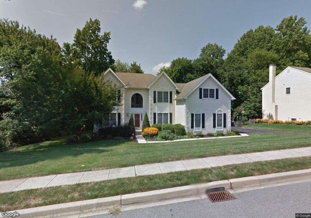
220 Walker Way Newark, DE 19711
Estimated Value: $721,000 - $868,000
4
Beds
4
Baths
3,071
Sq Ft
$258/Sq Ft
Est. Value
About This Home
This home is located at 220 Walker Way, Newark, DE 19711 and is currently estimated at $791,875, approximately $257 per square foot. 220 Walker Way is a home located in New Castle County with nearby schools including R. Elisabeth Maclary Elementary School, Shue-Medill Middle School, and Newark High School.
Ownership History
Date
Name
Owned For
Owner Type
Purchase Details
Closed on
Apr 4, 2025
Sold by
Diemidio Joseph M and Diemidio Christa L
Bought by
Revocable Deed Of Trust Of Joseph M Diemidio and Diemidio
Current Estimated Value
Purchase Details
Closed on
Mar 15, 2005
Sold by
Addiego James B and Addiego Karen M
Bought by
Diemidio Joseph M and Diemidio Christa L
Home Financials for this Owner
Home Financials are based on the most recent Mortgage that was taken out on this home.
Original Mortgage
$295,500
Interest Rate
4.37%
Mortgage Type
Fannie Mae Freddie Mac
Create a Home Valuation Report for This Property
The Home Valuation Report is an in-depth analysis detailing your home's value as well as a comparison with similar homes in the area
Home Values in the Area
Average Home Value in this Area
Purchase History
| Date | Buyer | Sale Price | Title Company |
|---|---|---|---|
| Revocable Deed Of Trust Of Joseph M Diemidio | -- | None Listed On Document | |
| Diemidio Joseph M | $495,500 | The Security Title Guarantee |
Source: Public Records
Mortgage History
| Date | Status | Borrower | Loan Amount |
|---|---|---|---|
| Previous Owner | Diemidio Joseph M | $295,500 |
Source: Public Records
Tax History Compared to Growth
Tax History
| Year | Tax Paid | Tax Assessment Tax Assessment Total Assessment is a certain percentage of the fair market value that is determined by local assessors to be the total taxable value of land and additions on the property. | Land | Improvement |
|---|---|---|---|---|
| 2024 | $1,532 | $145,200 | $17,600 | $127,600 |
| 2023 | $5,251 | $145,200 | $17,600 | $127,600 |
| 2022 | $5,195 | $145,200 | $17,600 | $127,600 |
| 2021 | $5,061 | $145,200 | $17,600 | $127,600 |
| 2020 | $4,916 | $145,200 | $17,600 | $127,600 |
| 2019 | $5,055 | $145,200 | $17,600 | $127,600 |
| 2018 | $4,209 | $145,200 | $17,600 | $127,600 |
| 2017 | $4,085 | $145,200 | $17,600 | $127,600 |
| 2016 | $4,073 | $145,200 | $17,600 | $127,600 |
| 2015 | $3,651 | $145,200 | $17,600 | $127,600 |
| 2014 | $3,650 | $145,200 | $17,600 | $127,600 |
Source: Public Records
Map
Nearby Homes
- 221 Cullen Way
- 211 Cullen Way
- 230 Aronimink Dr
- 6 Shenandoah Dr
- 335 Old Paper Mill Rd
- 300 Capitol Trail
- 305 Poplar Ave
- 324 Delaplane Ave
- 109 Mulberry Rd
- 402 Stafford Ave
- 344 Delaware Cir
- 311 Stamford Dr
- 506 Cambridge Dr
- 123 Unami Trail
- 424 Brewster Dr
- 132 Osage Ln
- 91 Old Red Mill Rd
- 7 Warbler Ct
- 25 Brentwood Ln
- 8 Peacock Place