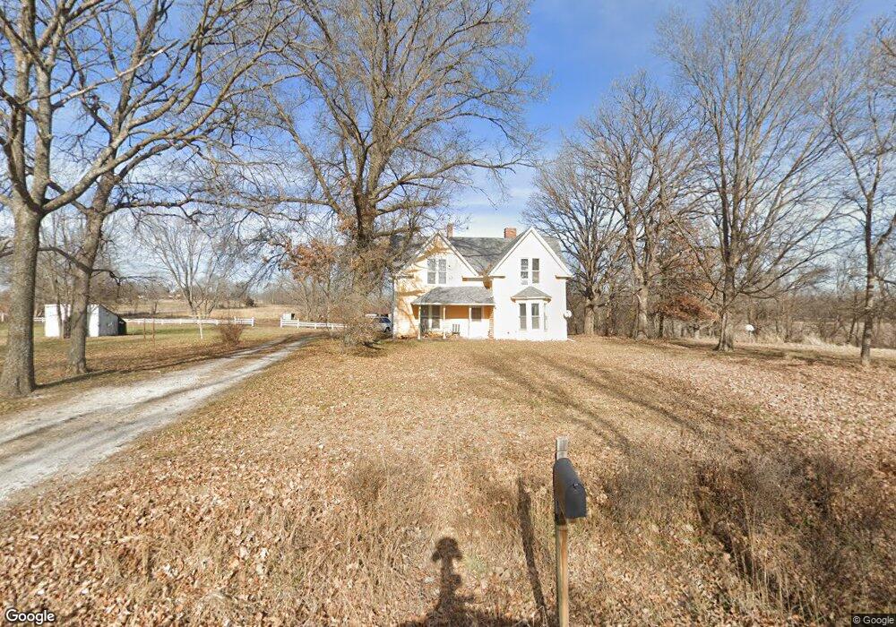
22001 NE 164th St Kearney, MO 64060
Estimated Value: $320,000 - $454,666
3
Beds
1
Bath
1,600
Sq Ft
$245/Sq Ft
Est. Value
About This Home
This home is located at 22001 NE 164th St, Kearney, MO 64060 and is currently estimated at $392,555, approximately $245 per square foot. 22001 NE 164th St is a home located in Clay County with nearby schools including Kearney Junior High School and Kearney High School.
Ownership History
Date
Name
Owned For
Owner Type
Purchase Details
Closed on
Jan 9, 1997
Sold by
Christianson Thomas C and Christianson Kathleen M
Bought by
Thomas C Christianson Trust
Current Estimated Value
Create a Home Valuation Report for This Property
The Home Valuation Report is an in-depth analysis detailing your home's value as well as a comparison with similar homes in the area
Home Values in the Area
Average Home Value in this Area
Purchase History
| Date | Buyer | Sale Price | Title Company |
|---|---|---|---|
| Thomas C Christianson Trust | -- | -- |
Source: Public Records
Tax History Compared to Growth
Tax History
| Year | Tax Paid | Tax Assessment Tax Assessment Total Assessment is a certain percentage of the fair market value that is determined by local assessors to be the total taxable value of land and additions on the property. | Land | Improvement |
|---|---|---|---|---|
| 2025 | $1,804 | $32,240 | -- | -- |
| 2024 | $1,804 | $28,520 | -- | -- |
| 2023 | $1,798 | $28,520 | $0 | $0 |
| 2022 | $1,593 | $24,480 | $0 | $0 |
| 2021 | $1,559 | $25,346 | $10,754 | $14,592 |
| 2020 | $1,712 | $24,420 | $0 | $0 |
| 2019 | $1,702 | $24,420 | $0 | $0 |
| 2018 | $1,531 | $21,230 | $0 | $0 |
| 2017 | $1,513 | $21,230 | $6,170 | $15,060 |
| 2016 | $1,513 | $21,230 | $6,170 | $15,060 |
| 2015 | $1,513 | $21,230 | $6,170 | $15,060 |
| 2014 | $1,438 | $20,060 | $6,120 | $13,940 |
Source: Public Records
Map
Nearby Homes
- 15617 Oakmont Dr
- 16211 Dr
- 16115 Kountry Ridge Dr
- 21619 NE 150th St
- 15025 Jesse James Farm Rd
- 25607 High Dr
- 610 E Porter Ridge Ct
- 1300 Melissa Ct
- 1302 Melissa Ct
- 1210 E 15th St
- 1043 E 14th St
- 817 Porter Ridge Rd
- 1610 Renea Ct
- 205 E Washington St
- 201 E Washington St
- 102 W Lawrence St
- 1204 Susan St
- 1102 Noah's Ln
- 1307 Stonecrest Dr
- 1205 Noah's Ln
- 21820 NE 164th St
- 16313 Hideout Dr
- 16320 Hideout Dr
- 21615 Jesse James Farm Rd
- 16221 Hideout Dr
- 16408 Old Bb Hwy
- 22210 NE 164th St
- 21608 Jesse James Farm Rd
- 16308 Marcrest Dr
- 16224 Hideout Dr
- 16422 Old Bb Hwy
- 16318 Marcrest Dr
- 16224 Marcrest Dr
- 16210 Hideout Dr
- 16512 Old Bb Hwy
- 21805 NE 162nd St
- 16607 Old Bb Hwy
- 21608 NE 162nd St
- 22408 NE 164th St
- 16524 Old Bb Hwy