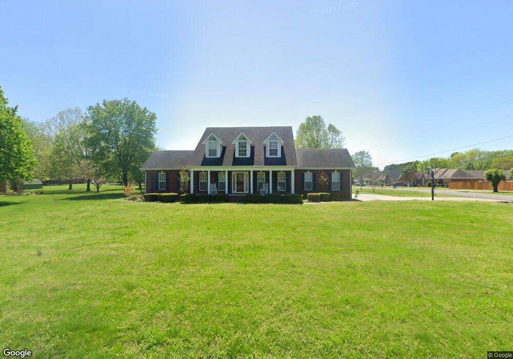
2202 Red Mile Rd Murfreesboro, TN 37127
Estimated Value: $491,876 - $524,000
3
Beds
3
Baths
2,508
Sq Ft
$201/Sq Ft
Est. Value
About This Home
This home is located at 2202 Red Mile Rd, Murfreesboro, TN 37127 and is currently estimated at $502,969, approximately $200 per square foot. 2202 Red Mile Rd is a home located in Rutherford County with nearby schools including Buchanan Elementary School, Whitworth-Buchanan Middle School, and Riverdale High School.
Ownership History
Date
Name
Owned For
Owner Type
Purchase Details
Closed on
Dec 7, 2016
Sold by
Jernigan Tammy A
Bought by
Jernigan James W
Current Estimated Value
Home Financials for this Owner
Home Financials are based on the most recent Mortgage that was taken out on this home.
Original Mortgage
$142,500
Outstanding Balance
$114,888
Interest Rate
3.47%
Mortgage Type
New Conventional
Estimated Equity
$388,081
Purchase Details
Closed on
Apr 21, 1997
Sold by
Christensen Ann B
Bought by
Jernigan James W and Jernigan Tam
Create a Home Valuation Report for This Property
The Home Valuation Report is an in-depth analysis detailing your home's value as well as a comparison with similar homes in the area
Home Values in the Area
Average Home Value in this Area
Purchase History
| Date | Buyer | Sale Price | Title Company |
|---|---|---|---|
| Jernigan James W | -- | None Available | |
| Jernigan James W | $24,000 | -- |
Source: Public Records
Mortgage History
| Date | Status | Borrower | Loan Amount |
|---|---|---|---|
| Open | Jernigan James W | $142,500 |
Source: Public Records
Tax History
| Year | Tax Paid | Tax Assessment Tax Assessment Total Assessment is a certain percentage of the fair market value that is determined by local assessors to be the total taxable value of land and additions on the property. | Land | Improvement |
|---|---|---|---|---|
| 2025 | $1,802 | $96,038 | $13,750 | $82,288 |
| 2024 | $1,802 | $96,038 | $13,750 | $82,288 |
| 2023 | $1,812 | $96,588 | $13,750 | $82,838 |
| 2022 | $1,561 | $96,588 | $13,750 | $82,838 |
| 2021 | $1,441 | $64,913 | $11,250 | $53,663 |
| 2020 | $1,441 | $64,913 | $11,250 | $53,663 |
| 2019 | $1,441 | $64,913 | $11,250 | $53,663 |
| 2018 | $1,363 | $64,913 | $0 | $0 |
| 2017 | $1,304 | $48,650 | $0 | $0 |
| 2016 | $1,304 | $48,650 | $0 | $0 |
| 2015 | $1,304 | $48,650 | $0 | $0 |
| 2014 | $1,210 | $48,650 | $0 | $0 |
| 2013 | -- | $50,075 | $0 | $0 |
Source: Public Records
Map
Nearby Homes
- 1926 Irby Ln
- 1680 Irby Ln
- 2021 Keenland Dr
- 2655 Manchester Pike
- 2306 Red Mile Rd
- 2341 Fig Dr
- 2363 Irby Ln
- 2422 Turtle Trace
- 1709 Thomas Ct
- 2223 Viking Ct
- 3260 Bradyville Pike
- 3416 Plum Leaf Place
- 2260 Viking Ct
- 3266 Bradyville Pike
- 3523 Plum Leaf Place
- 2614 Elam Rd
- 1607 Kensington Dr
- 2742 Candlewick Ct
- 2105 Wimbledon Rd
- 2022 Tobey Ln
- 2713 Brittany Trace
- 2208 Red Mile Rd
- 2719 Brittany Trace
- 2201 Red Mile Rd
- 2712 Brittany Trace
- 2134 Red Mile Rd
- 2212 Red Mile Rd
- 2139 Red Mile Rd
- 2209 Red Mile Rd
- 2718 Brittany Trace
- 2723 Brittany Trace
- 2128 Red Mile Rd
- 130 Marauder Ct
- 2722 Brittany Trace
- 2213 Red Mile Rd
- 2216 Red Mile Rd
- 126 Marauder Ct
- 2129 Red Mile Rd
- 2711 Boxwood Ln
- 2707 Boxwood Ln
Your Personal Tour Guide
Ask me questions while you tour the home.