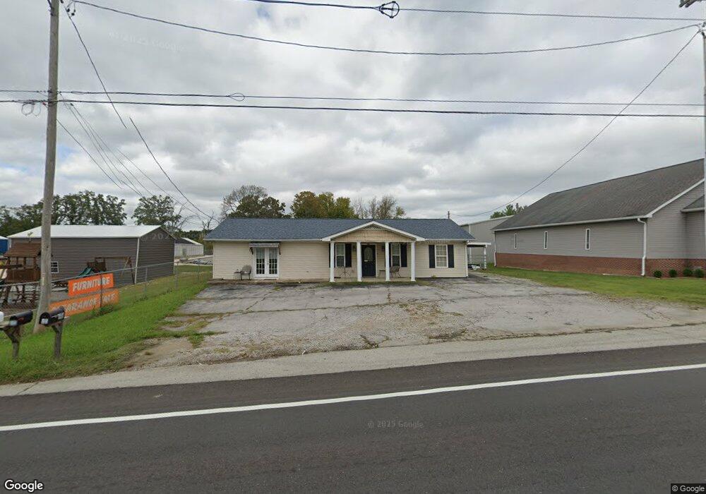
2203 W Broad St Cookeville, TN 38501
Estimated Value: $401,000 - $440,421
--
Bed
4
Baths
3,412
Sq Ft
$121/Sq Ft
Est. Value
About This Home
This home is located at 2203 W Broad St, Cookeville, TN 38501 and is currently estimated at $412,855, approximately $121 per square foot. 2203 W Broad St is a home located in Putnam County with nearby schools including Cane Creek Elementary School, Upperman Middle School, and Upperman High School.
Ownership History
Date
Name
Owned For
Owner Type
Purchase Details
Closed on
Aug 25, 2014
Sold by
L C Suggs Flp
Bought by
Suggs Larry K
Current Estimated Value
Purchase Details
Closed on
Dec 29, 2009
Sold by
Suggs Lucille
Bought by
Suggs Larry
Purchase Details
Closed on
May 12, 2008
Sold by
Suggs Charlotte J
Bought by
Suggs Larry K
Purchase Details
Closed on
Apr 11, 2008
Sold by
Suggs Mark E
Bought by
Lucille Suggs
Purchase Details
Closed on
Oct 4, 2000
Sold by
Suggs Charlotte J
Bought by
L & C Second Family Lp
Purchase Details
Closed on
Nov 4, 1991
Bought by
Suggs Larry K
Purchase Details
Closed on
Mar 15, 1989
Bought by
Byers Louis Clay
Purchase Details
Closed on
Jan 1, 1983
Bought by
Grogan Donald H
Create a Home Valuation Report for This Property
The Home Valuation Report is an in-depth analysis detailing your home's value as well as a comparison with similar homes in the area
Home Values in the Area
Average Home Value in this Area
Purchase History
| Date | Buyer | Sale Price | Title Company |
|---|---|---|---|
| Suggs Larry K | -- | -- | |
| Suggs Larry | -- | -- | |
| Suggs Larry K | -- | -- | |
| Lucille Suggs | -- | -- | |
| L & C Second Family Lp | -- | -- | |
| Suggs Larry K | $43,000 | -- | |
| Byers Louis Clay | $32,000 | -- | |
| Grogan Donald H | -- | -- |
Source: Public Records
Tax History Compared to Growth
Tax History
| Year | Tax Paid | Tax Assessment Tax Assessment Total Assessment is a certain percentage of the fair market value that is determined by local assessors to be the total taxable value of land and additions on the property. | Land | Improvement |
|---|---|---|---|---|
| 2024 | $2,827 | $106,280 | $12,000 | $94,280 |
| 2023 | $2,827 | $106,280 | $12,000 | $94,280 |
| 2022 | $2,627 | $106,280 | $12,000 | $94,280 |
| 2021 | $1,642 | $66,425 | $7,500 | $58,925 |
| 2020 | $1,265 | $66,425 | $7,500 | $58,925 |
| 2019 | $1,101 | $37,625 | $6,250 | $31,375 |
| 2018 | $1,027 | $37,625 | $6,250 | $31,375 |
| 2017 | $1,027 | $37,625 | $6,250 | $31,375 |
| 2016 | $1,027 | $37,625 | $6,250 | $31,375 |
| 2015 | $1,055 | $37,625 | $6,250 | $31,375 |
| 2014 | $1,017 | $36,244 | $0 | $0 |
Source: Public Records
Map
Nearby Homes
- 2136 W Broad St
- 270 Locust Grove Rd
- 279 Willow Brook Dr
- 0 Corner of W Broad St & Tn Ave Unit RTC2794105
- 2.52 St
- 2911 Grand Ridge Dr
- 1957 W Broad St
- Lot 3 Miller
- 500 N McBroom Chapel Rd
- 2.52 ac W Broad St
- 553 County Farm Rd
- 4131 Charlton Square
- 4060 Charlton Square
- 2300 Sun Valley Cir
- 1408 Oak Grove Dr
- 1405 Brook Hill Dr
- 1711 Creekside Dr
- 2193 W Broad St
- 2235 W Broad St
- 2240 W Broad St
- 2254 W Broad St
- 2146 W Broad St
- 133 Locust Grove Rd
- 2258 W Broad St Unit 1
- 2258 W Broad St
- 125 Locust Grove Rd
- 145 Locust Grove Rd
- 2268 W Broad St
- 2270 W Broad St
- 181 Speck Rd
- 2117 W Broad St
- 2158 W Broad St
- 264 Thomas Rd
- 2120 W Broad St
- 205 Speck Rd
- 199 Locust Grove Rd
- 2290 W Broad St