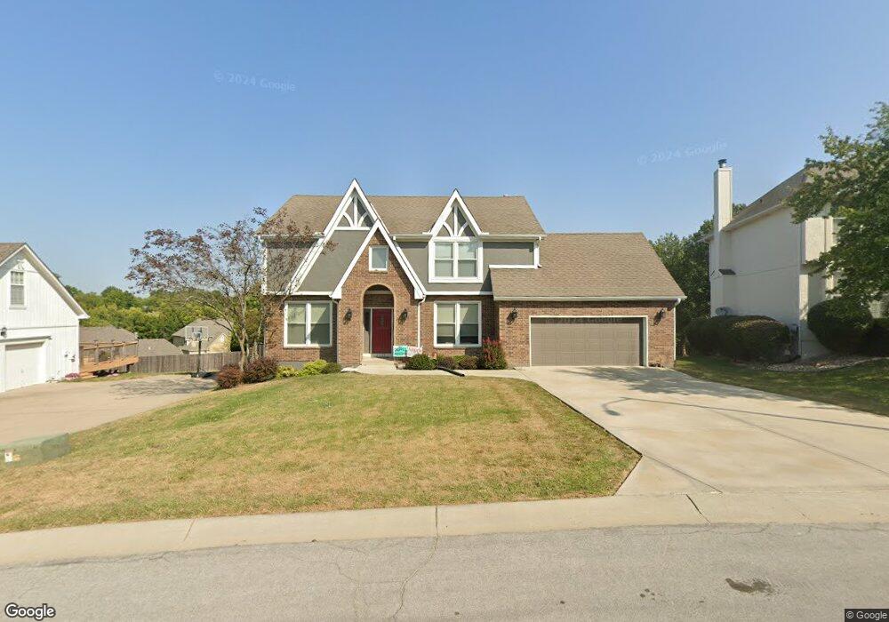
2204 NW Ashurst Dr Lees Summit, MO 64081
Estimated Value: $432,267 - $614,000
4
Beds
3
Baths
2,570
Sq Ft
$194/Sq Ft
Est. Value
About This Home
This home is located at 2204 NW Ashurst Dr, Lees Summit, MO 64081 and is currently estimated at $497,817, approximately $193 per square foot. 2204 NW Ashurst Dr is a home located in Jackson County with nearby schools including Cedar Creek Elementary School, Pleasant Lea Middle School, and Lee's Summit Senior High School.
Ownership History
Date
Name
Owned For
Owner Type
Purchase Details
Closed on
Jun 18, 2013
Sold by
Parker Steven H and Parker Kathleen
Bought by
Parker Steven H and Parker Kathleen H
Current Estimated Value
Purchase Details
Closed on
Oct 18, 1996
Sold by
Parker Wilburn H and Parker Edith M
Bought by
Parker Steven and Parker Kathleen
Create a Home Valuation Report for This Property
The Home Valuation Report is an in-depth analysis detailing your home's value as well as a comparison with similar homes in the area
Home Values in the Area
Average Home Value in this Area
Purchase History
| Date | Buyer | Sale Price | Title Company |
|---|---|---|---|
| Parker Steven H | -- | None Available | |
| Parker Steven | -- | -- |
Source: Public Records
Tax History Compared to Growth
Tax History
| Year | Tax Paid | Tax Assessment Tax Assessment Total Assessment is a certain percentage of the fair market value that is determined by local assessors to be the total taxable value of land and additions on the property. | Land | Improvement |
|---|---|---|---|---|
| 2025 | $4,527 | $72,105 | $11,229 | $60,876 |
| 2024 | $4,494 | $62,700 | $10,517 | $52,183 |
| 2023 | $4,494 | $62,701 | $10,517 | $52,184 |
| 2022 | $4,709 | $58,330 | $7,581 | $50,749 |
| 2021 | $4,806 | $58,330 | $7,581 | $50,749 |
| 2020 | $4,847 | $58,257 | $7,581 | $50,676 |
| 2019 | $4,715 | $58,257 | $7,581 | $50,676 |
| 2018 | $4,413 | $50,595 | $5,700 | $44,895 |
| 2017 | $4,185 | $50,595 | $5,700 | $44,895 |
| 2016 | $4,185 | $47,500 | $6,384 | $41,116 |
| 2014 | $4,027 | $44,800 | $6,371 | $38,429 |
Source: Public Records
Map
Nearby Homes
- 2122 NW Ashurst Dr
- 2110 NW Ashurst Dr
- 2209 NW Wellington Ct
- 505 NW Ambersham Dr
- 2082 NW O'Brien Rd
- 2086 NW O'Brien Rd
- 2090 NW O'Brien Rd
- 130 NW Ambersham Dr
- 361 NW Patch Ct
- Monterey Plan at Reserve at Woodside Ridge
- Oakleigh Plan at Reserve at Woodside Ridge
- Ashland Plan at Reserve at Woodside Ridge
- Bentley Plan at Reserve at Woodside Ridge
- Mariah Plan at Reserve at Woodside Ridge
- Oakshire Plan at Reserve at Woodside Ridge
- Forrester II Plan at Reserve at Woodside Ridge
- Forrester 2824 Plan at Reserve at Woodside Ridge
- Regency Plan at Reserve at Woodside Ridge
- Windsong Plan at Reserve at Woodside Ridge
- Carolina Plan at Reserve at Woodside Ridge
- 2200 NW Ashurst Dr
- 2208 NW Ashurst Dr
- 2201 NW Ashurst Dr
- 2205 NW Ashurst Dr
- 2033 Ashurst Dr
- 2126 NW Ashurst Dr
- 505 NW Highcliffe Dr
- 2209 NW Ashurst Dr
- 509 NW Highcliffe Dr
- 2125 NW Ashurst Dr
- 513 NW Highcliffe Ct
- 501 NW Highcliffe Dr
- 517 NW Highcliffe Ct
- 2213 NW Ashurst Dr
- 432 NW Kaylea Ct
- 508 NW Highcliffe Dr
- 521 NW Highcliffe Ct
- 405 NW Highcliffe Dr
- 409 NW Highcliffe Dr
- 2114 NW Ashurst Dr