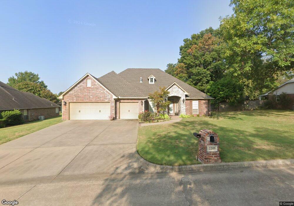
2209 Michael Rd Muskogee, OK 74403
Country Club NeighborhoodEstimated Value: $312,000 - $367,327
3
Beds
3
Baths
2,442
Sq Ft
$141/Sq Ft
Est. Value
About This Home
This home is located at 2209 Michael Rd, Muskogee, OK 74403 and is currently estimated at $343,832, approximately $140 per square foot. 2209 Michael Rd is a home located in Muskogee County with nearby schools including 8th & 9th Grade Academy @ Alice Robertson, Muskogee High School, and St Joseph Catholic School.
Ownership History
Date
Name
Owned For
Owner Type
Purchase Details
Closed on
Jan 31, 2022
Sold by
Jackson Betty A
Bought by
Jackson Brian Kelly and Jackson Gary Todd
Current Estimated Value
Purchase Details
Closed on
Dec 15, 2008
Sold by
Tinnin Stephen A and Tinnin Bethlyn V
Bought by
Jackson Gary B and Jackson Betty A
Purchase Details
Closed on
Sep 20, 2007
Sold by
Timin Tom J and Timin Wanda G
Bought by
Timin Stephen A and Timin Bethlyn
Home Financials for this Owner
Home Financials are based on the most recent Mortgage that was taken out on this home.
Original Mortgage
$232,000
Interest Rate
6.55%
Mortgage Type
Future Advance Clause Open End Mortgage
Create a Home Valuation Report for This Property
The Home Valuation Report is an in-depth analysis detailing your home's value as well as a comparison with similar homes in the area
Home Values in the Area
Average Home Value in this Area
Purchase History
| Date | Buyer | Sale Price | Title Company |
|---|---|---|---|
| Jackson Brian Kelly | -- | None Listed On Document | |
| Jackson Gary B | $277,000 | Pioneer Abstract & Title Co | |
| Timin Stephen A | -- | None Available |
Source: Public Records
Mortgage History
| Date | Status | Borrower | Loan Amount |
|---|---|---|---|
| Previous Owner | Timin Stephen A | $232,000 |
Source: Public Records
Tax History Compared to Growth
Tax History
| Year | Tax Paid | Tax Assessment Tax Assessment Total Assessment is a certain percentage of the fair market value that is determined by local assessors to be the total taxable value of land and additions on the property. | Land | Improvement |
|---|---|---|---|---|
| 2025 | $3,773 | $36,359 | $1,549 | $34,810 |
| 2024 | $3,773 | $34,627 | $1,475 | $33,152 |
| 2023 | $3,773 | $34,627 | $1,320 | $33,307 |
| 2022 | $3,030 | $32,978 | $1,320 | $31,658 |
| 2021 | $2,953 | $30,493 | $1,914 | $28,579 |
| 2020 | $2,957 | $30,493 | $1,914 | $28,579 |
| 2019 | $2,934 | $30,494 | $1,914 | $28,580 |
| 2018 | $2,874 | $30,494 | $1,914 | $28,580 |
| 2017 | $2,780 | $30,493 | $1,914 | $28,579 |
| 2016 | $2,812 | $30,530 | $1,650 | $28,880 |
| 2015 | $2,785 | $30,530 | $1,650 | $28,880 |
| 2014 | $2,837 | $30,530 | $1,650 | $28,880 |
Source: Public Records
Map
Nearby Homes
- 3401 E Shawnee Bypass
- 3205 E Shawnee
- 3428 Harris Ave
- 3420 Harris Ave
- 3407 Harris
- 0 SW Shawnee Rd Unit 2514449
- 2505 Fort Davis Dr
- 2808 Suroya St
- 4114 Putter Place
- 2901 Robin Ln
- 2839 Hickory Creek Rd
- 3305 E Harris Rd
- 3611 N Country Club Cir
- 1813 N York St
- 3423 River Bend Rd
- 4010 E Harris Rd
- 0 N York St Unit 2517802
- 3821 N Country Club Cir
- 1411 N 43rd St E
- 1200 N Edmond St
- 2205 Michael Rd
- 2221 Michael Rd
- 2212 Park Cir
- 2208 Park Cir
- 2220 Michael Rd
- 3400 Michael Ct
- 2201 Michael Rd
- 2225 Michael Rd
- 3407 Hyde Park Ave
- 3312 Park Place N
- 2204 Park Cir
- 3501 Hyde Park Ave
- 3404 Michael Ct
- 2923 Huddersfield Ct
- 2227 N Country Club Rd
- 2225 N Country Club Rd
- 3405 Hyde Park Ave
- 3308 Park Place N
- 3400 Park Place N
- 3317 Park Place N