Estimated Value: $289,536 - $370,000
3
Beds
3
Baths
2,458
Sq Ft
$134/Sq Ft
Est. Value
About This Home
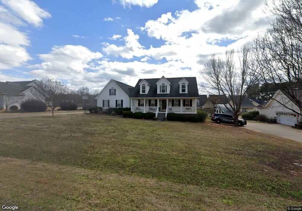
This home is located at 221 Laura Ln, Gray, GA 31032 and is currently estimated at $329,134, approximately $133 per square foot. 221 Laura Ln is a home located in Jones County with nearby schools including Gray Elementary School, Gray Station Middle School, and Jones County High School.
Ownership History
Date
Name
Owned For
Owner Type
Purchase Details
Closed on
Mar 22, 2018
Sold by
Meeks Toby A
Bought by
Kent Joshua L and Kent Sarina
Current Estimated Value
Home Financials for this Owner
Home Financials are based on the most recent Mortgage that was taken out on this home.
Original Mortgage
$194,085
Outstanding Balance
$166,394
Interest Rate
4.4%
Mortgage Type
VA
Estimated Equity
$162,740
Purchase Details
Closed on
Jan 21, 2009
Sold by
Meeks Toby A
Bought by
Meeks Toby A
Home Financials for this Owner
Home Financials are based on the most recent Mortgage that was taken out on this home.
Original Mortgage
$148,000
Interest Rate
5.23%
Mortgage Type
New Conventional
Purchase Details
Closed on
Dec 11, 2003
Sold by
Carlisle Gregory M
Bought by
Meeks Toby A
Purchase Details
Closed on
Mar 29, 2002
Sold by
George Luther Construction
Bought by
Carlisle Gregory M
Purchase Details
Closed on
Jan 16, 2001
Sold by
Milholen Properties
Bought by
George Luther Construction
Create a Home Valuation Report for This Property
The Home Valuation Report is an in-depth analysis detailing your home's value as well as a comparison with similar homes in the area
Home Values in the Area
Average Home Value in this Area
Purchase History
| Date | Buyer | Sale Price | Title Company |
|---|---|---|---|
| Kent Joshua L | $190,000 | -- | |
| Meeks Toby A | -- | -- | |
| Meeks Toby A | $162,000 | -- | |
| Carlisle Gregory M | $159,900 | -- | |
| George Luther Construction | $68,000 | -- |
Source: Public Records
Mortgage History
| Date | Status | Borrower | Loan Amount |
|---|---|---|---|
| Open | Kent Joshua L | $194,085 | |
| Previous Owner | Meeks Toby A | $148,000 |
Source: Public Records
Tax History Compared to Growth
Tax History
| Year | Tax Paid | Tax Assessment Tax Assessment Total Assessment is a certain percentage of the fair market value that is determined by local assessors to be the total taxable value of land and additions on the property. | Land | Improvement |
|---|---|---|---|---|
| 2023 | $3,667 | $78,230 | $9,200 | $69,030 |
| 2022 | $2,739 | $73,283 | $8,556 | $64,727 |
| 2021 | $2,743 | $73,283 | $8,556 | $64,727 |
| 2020 | $2,743 | $73,283 | $8,556 | $64,727 |
| 2019 | $2,743 | $73,283 | $8,556 | $64,727 |
| 2018 | $2,743 | $73,283 | $8,556 | $64,727 |
| 2017 | $2,743 | $73,283 | $8,556 | $64,727 |
| 2016 | $2,743 | $73,283 | $8,556 | $64,727 |
| 2015 | $2,601 | $73,283 | $8,556 | $64,727 |
| 2014 | $2,403 | $73,283 | $8,556 | $64,727 |
Source: Public Records
Map
Nearby Homes
- 193 Virginia Ave
- 202 Railroad St
- 0 Bill Conn Pkwy
- 206 Railroad St
- 151 Stone Brooke Dr
- 1023 Boulder Dr Unit LOT 65
- 1023 Boulder Dr
- 236 Old Clinton Rd
- 106 Davis St
- 238 Hidden Lakes Dr
- 250 Stone Brooke Dr Unit LOT 133
- 250 Stone Brooke Dr
- 124 Ridgecrest Place
- 139 Jackson Ave
- 00 Hidden Hills Ct
- LOT 1 C Georgia 18
- 734 Natures Walk
- 0 Sandra Dr Unit M179018
- 0 Sandra Dr Unit 52382
- 0 Sandra Dr Unit 10487926