Estimated Value: $107,023 - $138,000
3
Beds
1
Bath
1,073
Sq Ft
$112/Sq Ft
Est. Value
About This Home
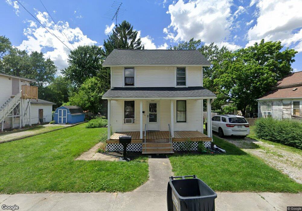
This home is located at 221 N Church St, Clyde, OH 43410 and is currently estimated at $120,256, approximately $112 per square foot. 221 N Church St is a home located in Sandusky County with nearby schools including Clyde High School, Harvest Temple Christian Academy, and St. Mary's School.
Ownership History
Date
Name
Owned For
Owner Type
Purchase Details
Closed on
Jun 12, 2023
Sold by
Big Bay 6 Llc
Bought by
Rockerlin Llc
Current Estimated Value
Purchase Details
Closed on
May 23, 2023
Sold by
Cc1 Oh Reo Llc
Bought by
Big Bay 6 Llc
Purchase Details
Closed on
Aug 29, 2022
Sold by
Tax Ease Ohio Llc
Bought by
Key Kable S and Key Joanna M
Purchase Details
Closed on
Jul 27, 2009
Sold by
Wott Gary L and Wott Sandra L
Bought by
Key Kable S and Key Joanna M
Purchase Details
Closed on
Sep 1, 1992
Bought by
Key Kable S and Key Joanna M
Create a Home Valuation Report for This Property
The Home Valuation Report is an in-depth analysis detailing your home's value as well as a comparison with similar homes in the area
Home Values in the Area
Average Home Value in this Area
Purchase History
| Date | Buyer | Sale Price | Title Company |
|---|---|---|---|
| Rockerlin Llc | $65,000 | None Listed On Document | |
| Rockerlin Llc | $65,000 | None Listed On Document | |
| Big Bay 6 Llc | $17,000 | Nova Title | |
| Key Kable S | -- | -- | |
| Key Kable S | -- | First American | |
| Key Kable S | -- | -- |
Source: Public Records
Tax History Compared to Growth
Tax History
| Year | Tax Paid | Tax Assessment Tax Assessment Total Assessment is a certain percentage of the fair market value that is determined by local assessors to be the total taxable value of land and additions on the property. | Land | Improvement |
|---|---|---|---|---|
| 2024 | $957 | $25,520 | $4,660 | $20,860 |
| 2023 | $957 | $20,410 | $3,710 | $16,700 |
| 2022 | $2,815 | $20,410 | $3,710 | $16,700 |
| 2021 | $842 | $20,410 | $3,710 | $16,700 |
| 2020 | $748 | $17,540 | $3,710 | $13,830 |
| 2019 | $739 | $17,540 | $3,710 | $13,830 |
| 2018 | $722 | $17,540 | $3,710 | $13,830 |
| 2017 | $704 | $16,280 | $3,710 | $12,570 |
| 2016 | $846 | $16,280 | $3,710 | $12,570 |
| 2015 | $833 | $16,280 | $3,710 | $12,570 |
| 2014 | $997 | $16,310 | $3,640 | $12,670 |
| 2013 | $791 | $16,310 | $3,640 | $12,670 |
Source: Public Records
Map
Nearby Homes
- 0 Ohio 101
- 1337 E Sr 20
- 0 W Mcpherson Hwy
- 118 E Buckeye St
- 167 Excalibur Dr
- 0 Ames St
- 625 Ames St
- 235 W Buckeye St
- 315 E Grant St
- 117 Nelson St
- 322 Vine St
- 209 Fair St
- 222 Bertha Ave
- 216 Grand Ave Unit 216
- 761 N Woodland Ave
- 0 Durnwald Dr
- CR 260 89.6 acres Durnwald Dr
- 628 W Maple St
- 153 Zimmerman Dr
- 1270 W Mcpherson Hwy
- 221 S Church St
- 225 N Church St
- 215 N Church St
- 231 N Church St
- 220 N Church St
- 237 N Church St
- 214 N Church St
- 163 Duane St
- 224 N Church St
- 167 Duane St
- 210 N Church St
- 241 N Church St
- 203 Duane St
- 153 Duane St
- 170 E Maple St
- 166 E Maple St
- 158 E Maple St
- 147 Duane St
- 207 Duane St Unit 209
- 178 E Maple St