Estimated Value: $171,000 - $214,000
4
Beds
1
Bath
1,920
Sq Ft
$101/Sq Ft
Est. Value
About This Home
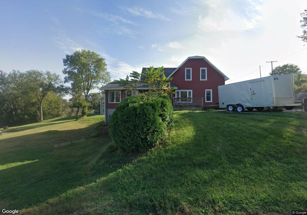
This home is located at 221 W 9th St, Logan, IA 51546 and is currently estimated at $193,859, approximately $100 per square foot. 221 W 9th St is a home located in Harrison County with nearby schools including Logan-Magnolia Elementary School and Logan-Magnolia Junior/Senior High School.
Ownership History
Date
Name
Owned For
Owner Type
Purchase Details
Closed on
Jun 26, 2009
Sold by
Porter Jeremy L
Bought by
Melby Talan
Current Estimated Value
Home Financials for this Owner
Home Financials are based on the most recent Mortgage that was taken out on this home.
Original Mortgage
$86,896
Outstanding Balance
$55,785
Interest Rate
5.07%
Mortgage Type
FHA
Estimated Equity
$138,074
Purchase Details
Closed on
Feb 27, 2008
Sold by
Deutsche Bank National Trust Co
Bought by
Porter Jeremy L and Porter Rachel M
Create a Home Valuation Report for This Property
The Home Valuation Report is an in-depth analysis detailing your home's value as well as a comparison with similar homes in the area
Home Values in the Area
Average Home Value in this Area
Purchase History
| Date | Buyer | Sale Price | Title Company |
|---|---|---|---|
| Melby Talan | $88,500 | None Available | |
| Porter Jeremy L | $51,000 | None Available |
Source: Public Records
Mortgage History
| Date | Status | Borrower | Loan Amount |
|---|---|---|---|
| Open | Melby Talan | $86,896 |
Source: Public Records
Tax History Compared to Growth
Tax History
| Year | Tax Paid | Tax Assessment Tax Assessment Total Assessment is a certain percentage of the fair market value that is determined by local assessors to be the total taxable value of land and additions on the property. | Land | Improvement |
|---|---|---|---|---|
| 2025 | $2,478 | $168,070 | $14,540 | $153,530 |
| 2024 | $2,478 | $151,270 | $14,540 | $136,730 |
| 2023 | $2,388 | $151,270 | $14,540 | $136,730 |
| 2022 | $2,012 | $112,136 | $14,535 | $97,601 |
| 2021 | $2,012 | $112,136 | $14,535 | $97,601 |
| 2020 | $1,816 | $104,656 | $14,535 | $90,121 |
| 2019 | $1,874 | $104,656 | $14,535 | $90,121 |
| 2018 | $1,722 | $96,453 | $0 | $0 |
| 2017 | $1,770 | $96,453 | $0 | $0 |
| 2016 | $1,804 | $96,453 | $0 | $0 |
| 2015 | $1,804 | $86,895 | $0 | $0 |
| 2014 | $1,570 | $86,895 | $0 | $0 |
Source: Public Records
Map
Nearby Homes
- 114 E 10th St
- 415 Wessar Dr
- 1010 Skyline Dr
- 721 Glen Rd
- Lot 18 Mulligan Trail
- LOT 27 Mulligan Trail
- 2484 280th St
- LOT 26 Lmvcc Estates
- 2607 220th St
- 2464 Mulligan Trail
- LOT 20 Lmvcc Estates
- LOT 17 Lmvcc Estates
- Lot 17 Lmvcc Estates Trail
- LOT 15 Mulligan Trail
- 2144 Norton Ave
- 2853 Preston Place
- 2740 Whitetail Dr
- LOT D Fieldcrest Dr
- LOT E & K Fieldcrest Dr
- LOT C Fieldcrest Dr