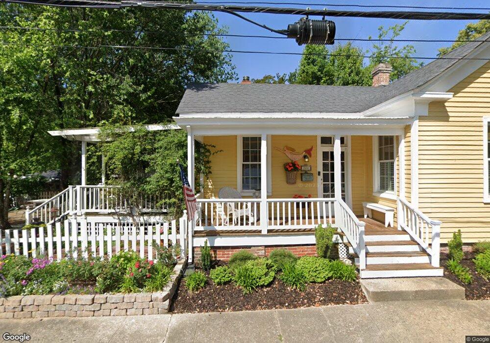
221 Washington St Hampton, VA 23669
Downtown Hampton NeighborhoodEstimated Value: $205,077 - $262,000
2
Beds
2
Baths
1,356
Sq Ft
$176/Sq Ft
Est. Value
About This Home
This home is located at 221 Washington St, Hampton, VA 23669 and is currently estimated at $239,269, approximately $176 per square foot. 221 Washington St is a home located in Hampton City with nearby schools including Capt. John Smith Elementary School, C. Alton Lindsay Middle School, and Phoebus High School.
Ownership History
Date
Name
Owned For
Owner Type
Purchase Details
Closed on
May 12, 1999
Sold by
Jellema Alice
Bought by
Mays Helen Regina
Current Estimated Value
Home Financials for this Owner
Home Financials are based on the most recent Mortgage that was taken out on this home.
Original Mortgage
$58,500
Outstanding Balance
$14,915
Interest Rate
6.88%
Estimated Equity
$224,354
Create a Home Valuation Report for This Property
The Home Valuation Report is an in-depth analysis detailing your home's value as well as a comparison with similar homes in the area
Home Values in the Area
Average Home Value in this Area
Purchase History
| Date | Buyer | Sale Price | Title Company |
|---|---|---|---|
| Mays Helen Regina | $53,000 | -- |
Source: Public Records
Mortgage History
| Date | Status | Borrower | Loan Amount |
|---|---|---|---|
| Open | Mays Helen Regina | $58,500 |
Source: Public Records
Tax History Compared to Growth
Tax History
| Year | Tax Paid | Tax Assessment Tax Assessment Total Assessment is a certain percentage of the fair market value that is determined by local assessors to be the total taxable value of land and additions on the property. | Land | Improvement |
|---|---|---|---|---|
| 2025 | $2,075 | $168,600 | $55,000 | $113,600 |
| 2024 | $1,932 | $168,000 | $55,000 | $113,000 |
| 2023 | $1,828 | $157,600 | $55,000 | $102,600 |
| 2022 | $1,692 | $143,400 | $50,000 | $93,400 |
| 2021 | $1,625 | $120,600 | $42,500 | $78,100 |
| 2020 | $1,452 | $117,100 | $41,400 | $75,700 |
| 2019 | $1,452 | $117,100 | $41,400 | $75,700 |
| 2018 | $1,571 | $117,100 | $41,400 | $75,700 |
| 2017 | $1,546 | $0 | $0 | $0 |
| 2016 | $1,546 | $117,100 | $0 | $0 |
| 2015 | $1,596 | $0 | $0 | $0 |
| 2014 | $1,586 | $121,100 | $41,400 | $79,700 |
Source: Public Records
Map
Nearby Homes
- 35 Miles Cary Mews
- 156 Mill Point Dr
- 115 E Pembroke Ave
- 418 Wine St
- 542 River St
- 433 Cooper St
- 439 Cooper St
- 14 Myrtle St
- 497 Bridge St
- 130 Meredith St
- 840 Quash St
- 138 Eberly Terrace
- 217 S Armistead Ave
- 144 Meredith St
- 210 Dockside Dr Unit A
- 116 Linden Ave
- 904 E Pembroke Ave
- 227 Dockside Dr Unit C
- 39 N Boxwood St
- 227 Lee St
- 218 Syms St
- 217 Washington St
- 226 Syms St
- 220 Washington St
- 222 Syms St
- 224 Washington St
- 270 Eaton St
- 290 Eaton St
- 228 Washington St
- 292 Eaton St
- 288 Eaton St
- 294 Eaton St
- 296 Eaton St
- 234 Washington St
- 298 Eaton St
- 312 Syms St
- 256 Mill Point Dr
- 301 Washington St
- 254 Mill Point Dr
- 252 Mill Point Dr