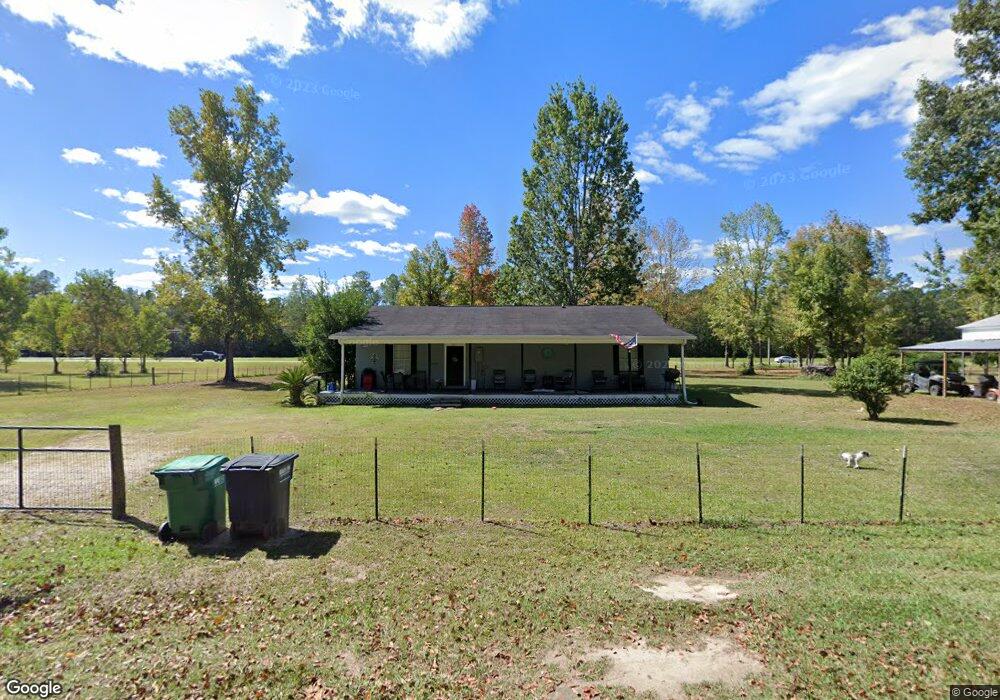
22109 William Ward Rd Moss Point, MS 39562
Estimated Value: $161,000 - $250,000
3
Beds
2
Baths
1,560
Sq Ft
$129/Sq Ft
Est. Value
About This Home
This home is located at 22109 William Ward Rd, Moss Point, MS 39562 and is currently estimated at $201,606, approximately $129 per square foot. 22109 William Ward Rd is a home located in Jackson County with nearby schools including East Central Lower Elementary School, East Central Upper Elementary School, and East Central Middle School.
Ownership History
Date
Name
Owned For
Owner Type
Purchase Details
Closed on
Sep 26, 2013
Sold by
Barrow James V
Bought by
White Bridget M
Current Estimated Value
Home Financials for this Owner
Home Financials are based on the most recent Mortgage that was taken out on this home.
Original Mortgage
$83,893
Outstanding Balance
$62,355
Interest Rate
4.53%
Mortgage Type
Purchase Money Mortgage
Estimated Equity
$139,251
Create a Home Valuation Report for This Property
The Home Valuation Report is an in-depth analysis detailing your home's value as well as a comparison with similar homes in the area
Purchase History
| Date | Buyer | Sale Price | Title Company |
|---|---|---|---|
| White Bridget M | -- | -- |
Source: Public Records
Mortgage History
| Date | Status | Borrower | Loan Amount |
|---|---|---|---|
| Open | White Bridget M | $83,893 |
Source: Public Records
Tax History
| Year | Tax Paid | Tax Assessment Tax Assessment Total Assessment is a certain percentage of the fair market value that is determined by local assessors to be the total taxable value of land and additions on the property. | Land | Improvement |
|---|---|---|---|---|
| 2025 | $139 | $9,655 | $799 | $8,856 |
| 2024 | $139 | $8,673 | $777 | $7,896 |
| 2023 | $141 | $8,673 | $777 | $7,896 |
| 2022 | $137 | $8,673 | $777 | $7,896 |
| 2021 | $720 | $8,747 | $777 | $7,970 |
| 2020 | $719 | $8,433 | $720 | $7,713 |
| 2019 | $708 | $8,433 | $720 | $7,713 |
| 2018 | $729 | $8,450 | $720 | $7,730 |
| 2017 | $747 | $8,450 | $720 | $7,730 |
| 2016 | $705 | $8,450 | $720 | $7,730 |
| 2015 | $1,405 | $78,330 | $7,200 | $71,130 |
| 2014 | $1,434 | $12,210 | $1,080 | $11,130 |
| 2013 | $73 | $8,140 | $720 | $7,420 |
Source: Public Records
Map
Nearby Homes
- Tbd Hurley Wade Rd
- 5402 Huckleberry Ln
- 24900 Polktown Rd
- 24040 Robert e Lee Rd
- 24023 Robert e Lee Rd
- 2538 Timber Ln
- 0 Cedar Creek Rd
- 6200 Hurley Wade Rd
- 125 Mulberry Dr
- 5901 Lum Reeves Rd
- 21217 E Trails End Rd
- 24258 Misty Ln
- 24900 Highway 613
- 0 Hwy 613 Unit 4108899
- 24997 Eastwood Ln
- 0 Mississippi 614
- 0000 Mississippi 614
- 0 Ramie Farm Rd
- 17209 Red Top Ln
- 0 Davis Dead River Dr Unit 4084515
- 22105 William Ward Rd
- 22113 William Ward Rd
- 22112 William Ward Rd
- 22201 William Ward Rd
- 2808 Sammie Hearndon Rd
- 22012 William Ward Rd
- 22213 Springfield Rd
- 21928 Cap Johnson Rd
- 21917 Cap Johnson Rd
- 21923 Cap Johnson Rd
- 22228 William Ward Rd
- 22105 Springfield Rd
- 22101 Springfield Rd
- 22043 Cap Johnson Rd
- 22100 Cap Johnson Rd
- 22029 Cap Johnson Rd
- 21835 Highway 63
- 22316 William Ward Rd
- 22106 Springfield Rd
- 22135 Cap Johnson Rd
Your Personal Tour Guide
Ask me questions while you tour the home.