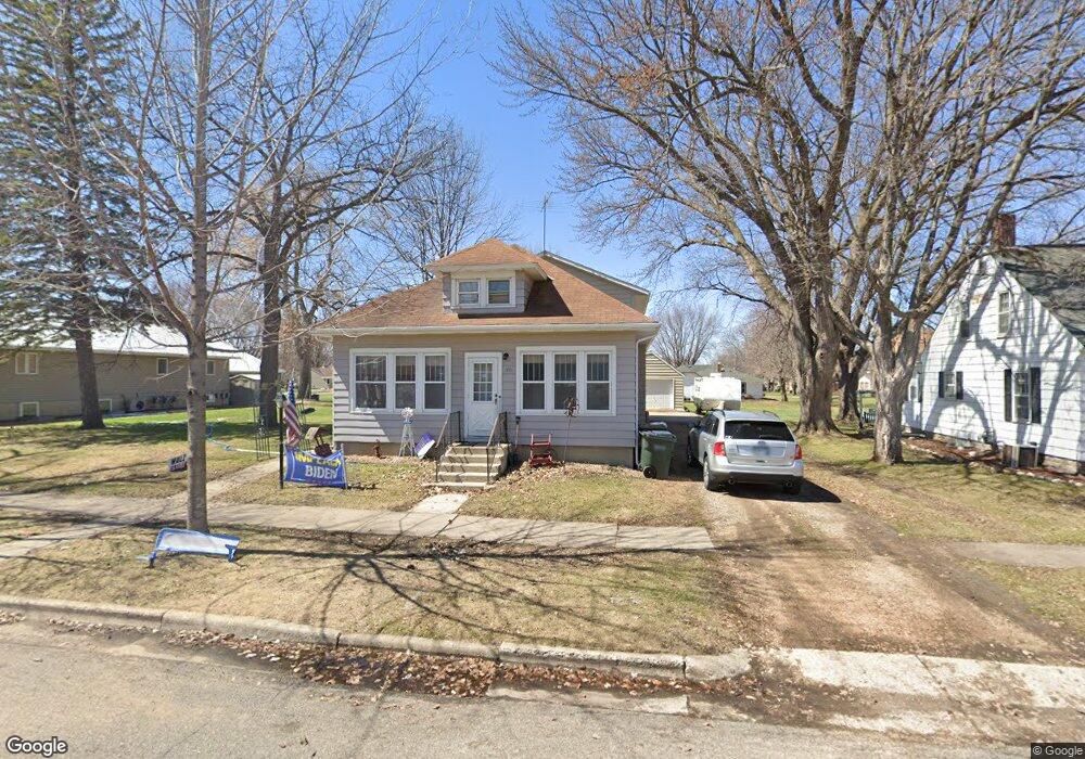
222 3rd Ave S Brownton, MN 55312
Estimated Value: $209,000 - $284,000
6
Beds
2
Baths
1,705
Sq Ft
$142/Sq Ft
Est. Value
About This Home
This home is located at 222 3rd Ave S, Brownton, MN 55312 and is currently estimated at $241,444, approximately $141 per square foot. 222 3rd Ave S is a home located in McLeod County with nearby schools including Lincoln Elementary School, Lakeside Elementary School, and Glencoe-Silver Lake Jr. High School.
Ownership History
Date
Name
Owned For
Owner Type
Purchase Details
Closed on
Nov 1, 2019
Sold by
Hermodson and Olsen Andrew
Bought by
Spreeman Erika L
Current Estimated Value
Home Financials for this Owner
Home Financials are based on the most recent Mortgage that was taken out on this home.
Original Mortgage
$142,274
Outstanding Balance
$126,428
Interest Rate
4.12%
Mortgage Type
FHA
Estimated Equity
$115,016
Create a Home Valuation Report for This Property
The Home Valuation Report is an in-depth analysis detailing your home's value as well as a comparison with similar homes in the area
Purchase History
| Date | Buyer | Sale Price | Title Company |
|---|---|---|---|
| Spreeman Erika L | $144,900 | Title Mark |
Source: Public Records
Mortgage History
| Date | Status | Borrower | Loan Amount |
|---|---|---|---|
| Open | Spreeman Erika L | $142,274 |
Source: Public Records
Tax History
| Year | Tax Paid | Tax Assessment Tax Assessment Total Assessment is a certain percentage of the fair market value that is determined by local assessors to be the total taxable value of land and additions on the property. | Land | Improvement |
|---|---|---|---|---|
| 2024 | $4,270 | $182,500 | $25,600 | $156,900 |
| 2023 | $4,270 | $182,500 | $25,600 | $156,900 |
| 2022 | $3,440 | $170,600 | $22,300 | $148,300 |
| 2021 | $3,504 | $147,700 | $19,400 | $128,300 |
| 2020 | $3,484 | $147,700 | $19,400 | $128,300 |
| 2019 | $2,346 | $133,900 | $17,600 | $116,300 |
| 2018 | $2,354 | $0 | $0 | $0 |
| 2017 | $1,880 | $0 | $0 | $0 |
| 2016 | $1,738 | $0 | $0 | $0 |
| 2015 | $1,576 | $0 | $0 | $0 |
| 2014 | -- | $0 | $0 | $0 |
Source: Public Records
Map
Nearby Homes
- xxx Lot 3 Division St W
- 237 5th St N
- Lot 2 U S Highway 212
- 0 Plum Ave Unit NOC6335195
- XXX US Hwy 212
- xxx Lot 2 Us Hwy 212
- 16452 90th St
- 0 57th St
- 12221 Page Ave
- 7900 Lace Ave
- 7900 Lace Ave N
- 12893 County Road 7
- Lot 2 Tagus Ave
- 630 Mowbray St
- 1199 E 2nd St
- 22447 150th St
- XXX 455th Ave
- XXX Airport Rd
- 511 Southfork Cir SE
- 1400 Sherwood St SE
Your Personal Tour Guide
Ask me questions while you tour the home.