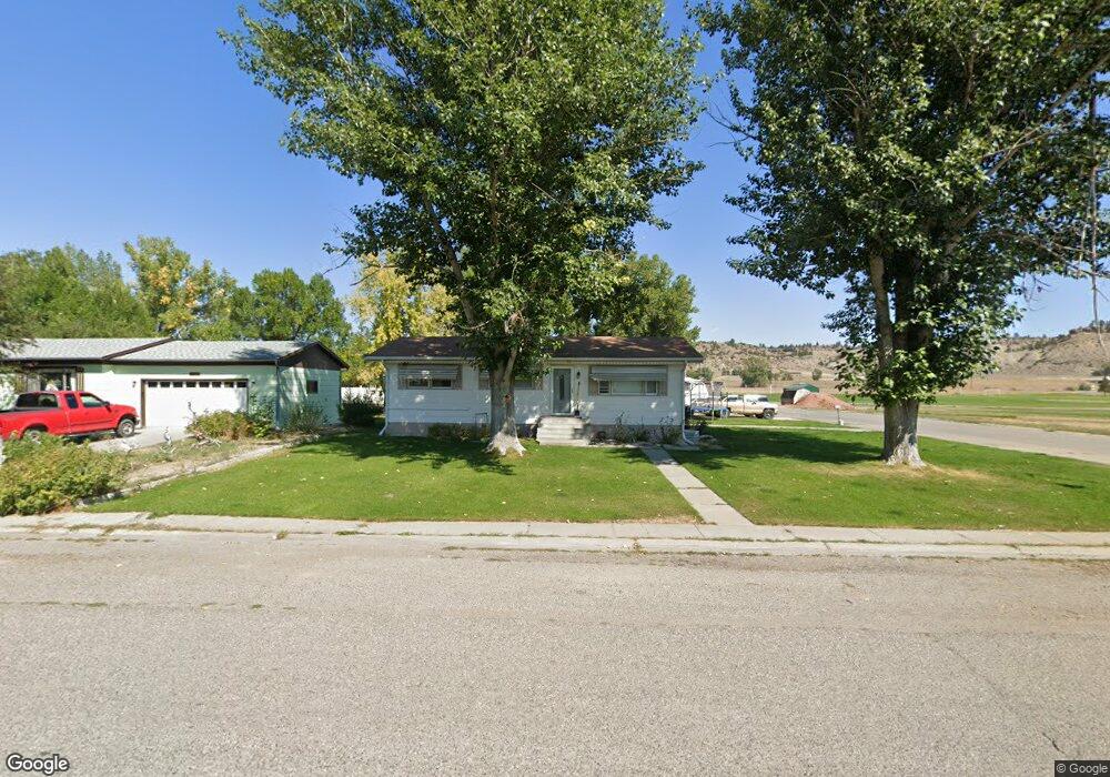
222 Annin Ave Columbus, MT 59019
Estimated Value: $302,979 - $332,000
5
Beds
1
Bath
1,152
Sq Ft
$275/Sq Ft
Est. Value
About This Home
This home is located at 222 Annin Ave, Columbus, MT 59019 and is currently estimated at $317,245, approximately $275 per square foot. 222 Annin Ave is a home located in Stillwater County with nearby schools including Columbus Elementary School and Columbus Middle School.
Ownership History
Date
Name
Owned For
Owner Type
Purchase Details
Closed on
Jun 8, 2010
Sold by
Oster Cheryl
Bought by
Emmett Adam and Emmett Christine E
Current Estimated Value
Home Financials for this Owner
Home Financials are based on the most recent Mortgage that was taken out on this home.
Original Mortgage
$156,994
Outstanding Balance
$105,630
Interest Rate
5.05%
Estimated Equity
$211,615
Purchase Details
Closed on
Jun 28, 2005
Sold by
Hanson Richard E and Hanson Carol A
Bought by
Oster Cheryl
Home Financials for this Owner
Home Financials are based on the most recent Mortgage that was taken out on this home.
Original Mortgage
$100,000
Interest Rate
5.72%
Create a Home Valuation Report for This Property
The Home Valuation Report is an in-depth analysis detailing your home's value as well as a comparison with similar homes in the area
Home Values in the Area
Average Home Value in this Area
Purchase History
| Date | Buyer | Sale Price | Title Company |
|---|---|---|---|
| Emmett Adam | -- | -- | |
| Oster Cheryl | -- | -- |
Source: Public Records
Mortgage History
| Date | Status | Borrower | Loan Amount |
|---|---|---|---|
| Open | Emmett Adam | $156,994 | |
| Previous Owner | Oster Cheryl | $100,000 |
Source: Public Records
Tax History Compared to Growth
Tax History
| Year | Tax Paid | Tax Assessment Tax Assessment Total Assessment is a certain percentage of the fair market value that is determined by local assessors to be the total taxable value of land and additions on the property. | Land | Improvement |
|---|---|---|---|---|
| 2025 | $1,650 | $317,100 | $0 | $0 |
| 2024 | $2,107 | $267,400 | $0 | $0 |
| 2023 | $2,044 | $267,400 | $0 | $0 |
| 2022 | $1,702 | $204,400 | $0 | $0 |
| 2021 | $1,688 | $204,400 | $0 | $0 |
| 2020 | $1,656 | $191,400 | $0 | $0 |
| 2019 | $1,754 | $191,400 | $0 | $0 |
| 2018 | $1,392 | $169,000 | $0 | $0 |
| 2017 | $1,509 | $169,000 | $0 | $0 |
| 2016 | $1,368 | $156,700 | $0 | $0 |
| 2015 | $1,281 | $156,700 | $0 | $0 |
| 2014 | $1,121 | $75,366 | $0 | $0 |
Source: Public Records
Map
Nearby Homes
- 427 N 4th St
- 115 W 6th Ave N
- 345 N 3rd St
- 692 Quarry Rd
- 219 4th St
- TBD Centennial Rd
- 526 E 2nd Ave N
- 55 Centennial Rd
- 136 W 1st Ave N
- 403 11th St N
- 1130 E 2nd Ave N
- 5 Michigan Ridge Rd
- 94 Upper Flat Rd
- 96 Wagon Trail Rd
- 49 Gateway Dr
- 66 Dolan Ln
- 11 E Upper Flat Rd
- 5 Shane Ridge Rd
- 381 Joliet Rd
- 4 Deer Dr