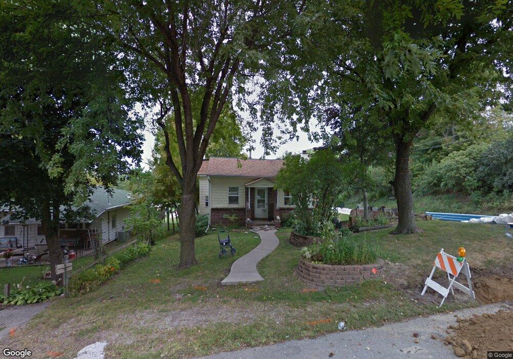
222 E Washington St Colfax, IA 50054
Estimated Value: $89,540 - $146,000
2
Beds
1
Bath
604
Sq Ft
$201/Sq Ft
Est. Value
About This Home
This home is located at 222 E Washington St, Colfax, IA 50054 and is currently estimated at $121,635, approximately $201 per square foot. 222 E Washington St is a home located in Jasper County with nearby schools including Colfax-Mingo Elementary School and Colfax-Mingo High School.
Ownership History
Date
Name
Owned For
Owner Type
Purchase Details
Closed on
Feb 15, 2007
Sold by
The Estate Of Wilma Lou Forck
Bought by
Forck Timothy J
Current Estimated Value
Home Financials for this Owner
Home Financials are based on the most recent Mortgage that was taken out on this home.
Original Mortgage
$50,000
Outstanding Balance
$30,131
Interest Rate
6.27%
Mortgage Type
New Conventional
Estimated Equity
$91,504
Create a Home Valuation Report for This Property
The Home Valuation Report is an in-depth analysis detailing your home's value as well as a comparison with similar homes in the area
Purchase History
| Date | Buyer | Sale Price | Title Company |
|---|---|---|---|
| Forck Timothy J | $50,000 | All American Escrow & Title |
Source: Public Records
Mortgage History
| Date | Status | Borrower | Loan Amount |
|---|---|---|---|
| Open | Forck Timothy J | $50,000 |
Source: Public Records
Tax History
| Year | Tax Paid | Tax Assessment Tax Assessment Total Assessment is a certain percentage of the fair market value that is determined by local assessors to be the total taxable value of land and additions on the property. | Land | Improvement |
|---|---|---|---|---|
| 2025 | $1,338 | $72,820 | $10,580 | $62,240 |
| 2024 | $1,338 | $70,250 | $10,580 | $59,670 |
| 2023 | $1,346 | $70,250 | $10,580 | $59,670 |
| 2022 | $1,216 | $57,220 | $10,580 | $46,640 |
| 2021 | $1,186 | $54,140 | $10,580 | $43,560 |
| 2020 | $1,186 | $49,740 | $7,040 | $42,700 |
| 2019 | $1,082 | $42,910 | $0 | $0 |
| 2018 | $1,082 | $42,910 | $0 | $0 |
| 2017 | $1,068 | $42,910 | $0 | $0 |
| 2016 | $1,068 | $42,910 | $0 | $0 |
| 2015 | $1,062 | $42,910 | $0 | $0 |
| 2014 | $1,010 | $42,910 | $0 | $0 |
Source: Public Records
Map
Nearby Homes
- 205 E Division St
- 222 E Broadway St
- 200 Jefferson St
- 226 S Iowa St
- 214 S Lincoln St
- 221 Cherry St
- 108 S Walnut St
- 238 S Walnut St
- 300 E Front St
- 655 E Division St
- 110 W Broadway St
- 400 S Goodrich St
- 000 College Ave
- 215 W Spring St
- 501 W Broadway St
- 17 S Kelly St
- 10114 S 34th Ave W
- 1132 S Goodrich St
- 1161 S Goodrich St
- 11213 Orchard Ave
- 216 E Washington St
- 225 E Division St
- 18 S Iowa St
- 215 E Division St
- 215 E Division St Unit A
- 105 S Iowa St
- 215 E Washington St
- 305 E Division St Unit A
- 305 E Division St
- 213 E Washington St
- 104 S Iowa St
- 104 S Iowa St Unit A
- 23 S Lincoln St
- 317 E Division St
- 311 E Division St
- 103 S Lincoln St
- 224 E Division St
- 236 E Broadway St
- 228 E Broadway St
- 306 E Division St
Your Personal Tour Guide
Ask me questions while you tour the home.