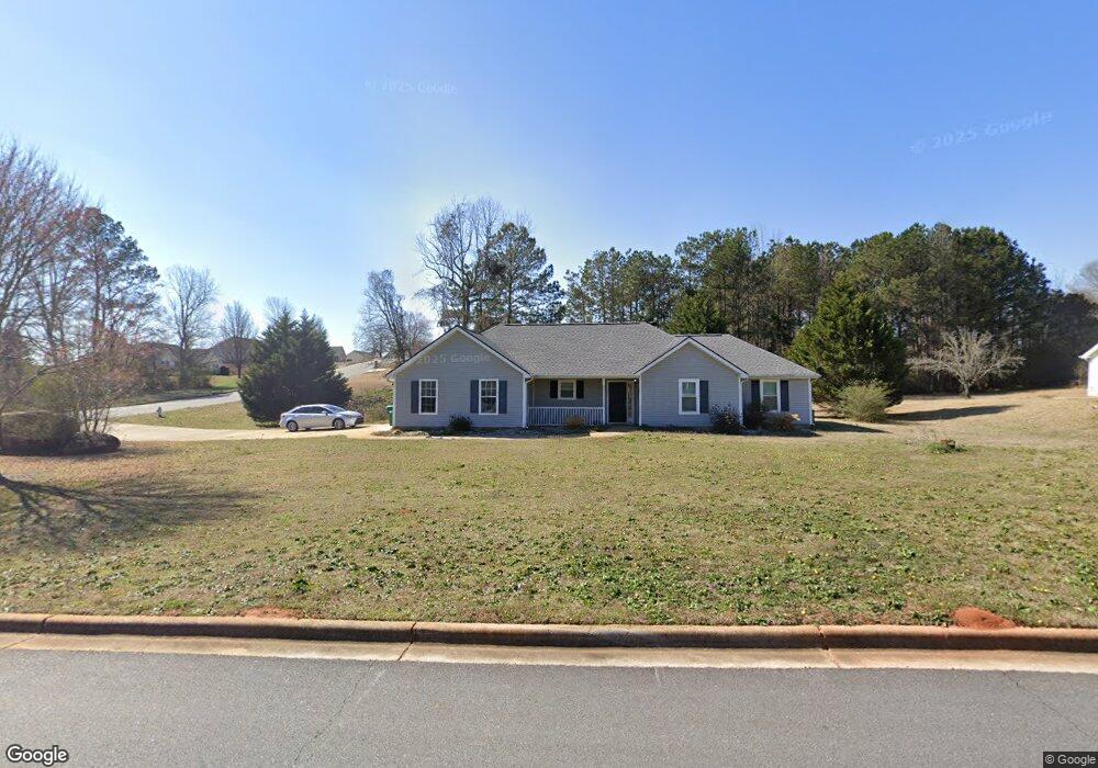
222 Ferguson Ave Locust Grove, GA 30248
Estimated Value: $252,567 - $276,000
3
Beds
2
Baths
1,430
Sq Ft
$184/Sq Ft
Est. Value
About This Home
This home is located at 222 Ferguson Ave, Locust Grove, GA 30248 and is currently estimated at $262,892, approximately $183 per square foot. 222 Ferguson Ave is a home located in Henry County with nearby schools including Locust Grove Elementary School, Locust Grove Middle School, and Locust Grove High School.
Ownership History
Date
Name
Owned For
Owner Type
Purchase Details
Closed on
May 1, 2023
Sold by
Wrpv Xiv Sfr Owner I Llc
Bought by
Wrpv Xiv Sfr Borrower Llc
Current Estimated Value
Purchase Details
Closed on
Aug 25, 2022
Sold by
Herlihy Mike
Bought by
Wrpv Xiv Sfr Owner I Llc
Purchase Details
Closed on
Jun 30, 1999
Sold by
Brenco Inc
Bought by
Herlihy Mike and Herlihy Stephanie J
Home Financials for this Owner
Home Financials are based on the most recent Mortgage that was taken out on this home.
Original Mortgage
$101,400
Interest Rate
7.43%
Mortgage Type
FHA
Create a Home Valuation Report for This Property
The Home Valuation Report is an in-depth analysis detailing your home's value as well as a comparison with similar homes in the area
Home Values in the Area
Average Home Value in this Area
Purchase History
| Date | Buyer | Sale Price | Title Company |
|---|---|---|---|
| Wrpv Xiv Sfr Borrower Llc | -- | -- | |
| Wrpv Xiv Sfr Owner I Llc | $247,000 | -- | |
| Herlihy Mike | $101,500 | -- |
Source: Public Records
Mortgage History
| Date | Status | Borrower | Loan Amount |
|---|---|---|---|
| Previous Owner | Herlihy Mike | $101,400 |
Source: Public Records
Tax History Compared to Growth
Tax History
| Year | Tax Paid | Tax Assessment Tax Assessment Total Assessment is a certain percentage of the fair market value that is determined by local assessors to be the total taxable value of land and additions on the property. | Land | Improvement |
|---|---|---|---|---|
| 2025 | $3,880 | $99,480 | $13,443 | $86,037 |
| 2024 | $3,880 | $99,480 | $14,000 | $85,480 |
| 2023 | $3,585 | $98,800 | $12,152 | $86,648 |
| 2022 | $2,321 | $81,280 | $14,000 | $67,280 |
| 2021 | $1,969 | $66,320 | $14,000 | $52,320 |
| 2020 | $1,812 | $59,680 | $12,000 | $47,680 |
| 2019 | $1,654 | $52,160 | $12,000 | $40,160 |
| 2018 | $1,592 | $49,880 | $10,800 | $39,080 |
| 2016 | $1,507 | $45,320 | $10,000 | $35,320 |
| 2015 | $1,424 | $42,280 | $10,000 | $32,280 |
| 2014 | $1,277 | $38,280 | $12,000 | $26,280 |
Source: Public Records
Map
Nearby Homes
- 231 Ferguson Ave
- 239 Ferguson Ave
- 143 Massey Ln
- 1064 Lear Dr
- 565 Carleton Place
- 150 Aster Ave
- Cali Plan at Cedar Ridge - Locust Grove Station
- Belfort Plan at Cedar Ridge - Locust Grove Station
- Galen Plan at Cedar Ridge - Locust Grove Station
- Hayden Plan at Cedar Ridge - Locust Grove Station
- Packard Plan at Cedar Ridge - Locust Grove Station
- Flora Plan at Cedar Ridge - Locust Grove Station
- Penwell Plan at Cedar Ridge - Locust Grove Station
- 269 Baumgard Way
- 188 Sophie Cir
- 501 Vervain Dr
- 0 Locust Rd Unit 10495072
- 0 Locust Rd Unit 19967321
- 380 Higgins Rd
- 198 Aster Ave
- 216 Ferguson Ave
- 226 Ferguson Ave
- 214 Ferguson Ave
- 228 Ferguson Ave
- 217 Ferguson Ave
- 219 Ferguson Ave
- 215 Ferguson Ave
- 229 Ferguson Ave
- 229 Ferguson Ave Unit 41
- 221 Ferguson Ave
- 230 Ferguson Ave
- 305 Harris Ave
- 213 Ferguson Ave
- 300 Harris Ave
- 2127 Theberton Trail Unit 265
- 2127 Theberton Trail
- 2129 Theberton Trail Unit 266
- 2129 Theberton Trail
- 2125 Theberton Trail Unit 264
- 2125 Theberton Trail