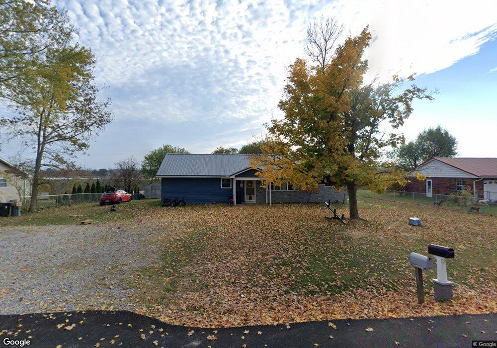
222 Hale Dr West Union, OH 45693
Estimated Value: $106,000 - $157,000
3
Beds
1
Bath
1,296
Sq Ft
$105/Sq Ft
Est. Value
About This Home
This home is located at 222 Hale Dr, West Union, OH 45693 and is currently estimated at $136,275, approximately $105 per square foot. 222 Hale Dr is a home located in Adams County with nearby schools including West Union Elementary School, West Union High School, and Adams County Christian School.
Ownership History
Date
Name
Owned For
Owner Type
Purchase Details
Closed on
Jul 26, 2022
Sold by
Kimmerly Karen A
Bought by
Fuchs Shane and Fuchs Ashle
Current Estimated Value
Purchase Details
Closed on
Aug 31, 2007
Sold by
Allen Mary E
Bought by
Kimmerly Karen A and Allen Fmary E
Purchase Details
Closed on
Apr 19, 2006
Sold by
Fannie Mae
Bought by
Allen Mary E
Home Financials for this Owner
Home Financials are based on the most recent Mortgage that was taken out on this home.
Original Mortgage
$40,000
Interest Rate
6.37%
Mortgage Type
New Conventional
Purchase Details
Closed on
Apr 14, 2005
Sold by
Lowder Richard D and Doe Jane
Bought by
Federal National Mortgage Association
Purchase Details
Closed on
Jan 28, 2004
Sold by
Fulton David B
Bought by
Lowder Richard D
Purchase Details
Closed on
Feb 19, 1975
Bought by
Fulton David B
Create a Home Valuation Report for This Property
The Home Valuation Report is an in-depth analysis detailing your home's value as well as a comparison with similar homes in the area
Home Values in the Area
Average Home Value in this Area
Purchase History
| Date | Buyer | Sale Price | Title Company |
|---|---|---|---|
| Fuchs Shane | -- | Moore Barbara A | |
| Fuchs Shane | -- | Moore Barbara A | |
| Kimmerly Karen A | -- | None Available | |
| Allen Mary E | $30,000 | Title First Agency Inc | |
| Federal National Mortgage Association | $44,000 | None Available | |
| Lowder Richard D | $65,000 | -- | |
| Fulton David B | $21,500 | -- |
Source: Public Records
Mortgage History
| Date | Status | Borrower | Loan Amount |
|---|---|---|---|
| Previous Owner | Allen Mary E | $40,000 |
Source: Public Records
Tax History Compared to Growth
Tax History
| Year | Tax Paid | Tax Assessment Tax Assessment Total Assessment is a certain percentage of the fair market value that is determined by local assessors to be the total taxable value of land and additions on the property. | Land | Improvement |
|---|---|---|---|---|
| 2024 | $1,377 | $24,890 | $4,380 | $20,510 |
| 2023 | $1,224 | $24,890 | $4,380 | $20,510 |
| 2022 | $854 | $21,850 | $3,330 | $18,520 |
| 2021 | $854 | $21,850 | $3,330 | $18,520 |
| 2020 | $832 | $21,850 | $3,330 | $18,520 |
| 2019 | $832 | $21,850 | $3,330 | $18,520 |
| 2018 | $701 | $18,770 | $3,330 | $15,440 |
| 2017 | $690 | $18,770 | $3,330 | $15,440 |
| 2016 | $689 | $18,770 | $3,330 | $15,440 |
| 2015 | $722 | $20,380 | $3,750 | $16,630 |
| 2014 | $723 | $20,380 | $3,750 | $16,630 |
Source: Public Records
Map
Nearby Homes
- 9598 State Route 41
- 40 Greenwood Ave
- 81 Evergreen St
- 0 Cic Blvd
- 271 Crawford Rd
- 1070 Eagle Creek Rd
- 4423 Pumpkin Ridge Rd
- 333 Crawford Rd
- 144 ac Pumpkin Ridge Rd
- 0 State Route 41 1 Acre Lot
- 223 Polk St
- 714 Panhandle Ave
- 408 W South St
- 286 & 290 S Market St
- 101 S Mound St
- 305 W Walnut St
- 216 S Market St
- 93 Jose Dr
- 302 W Main St
- 80 Madonna Dr