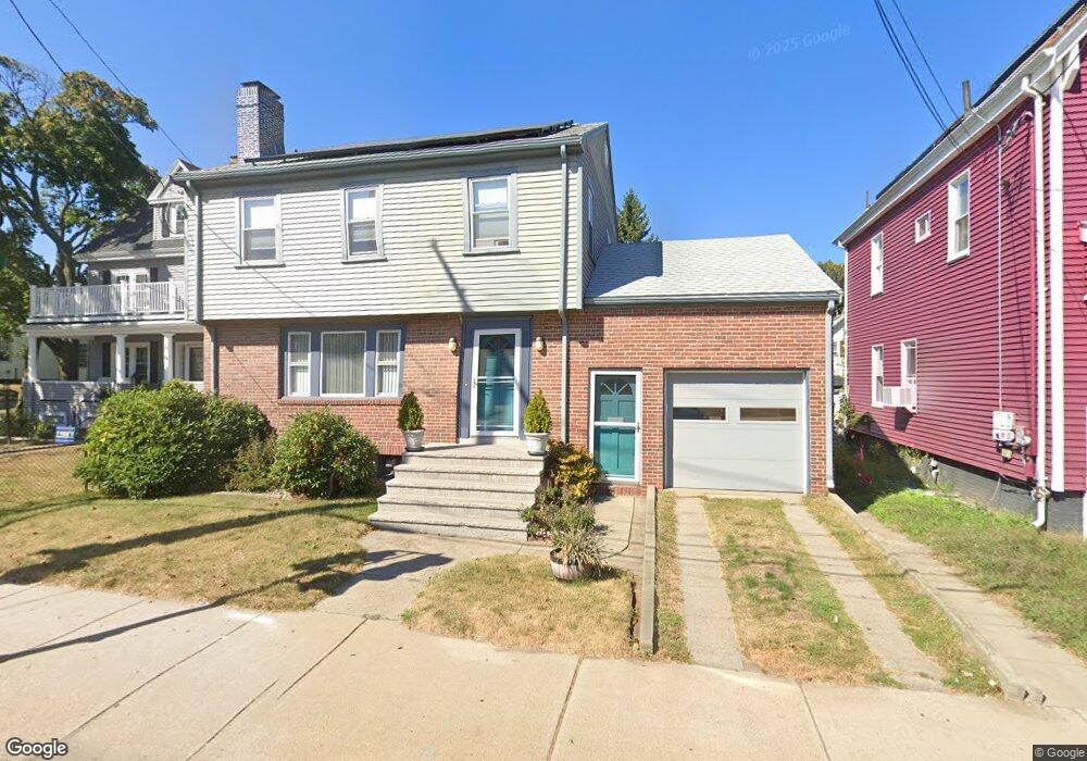
222 Main St Winthrop, MA 02152
Downtown Winthrop NeighborhoodEstimated Value: $724,000 - $760,526
3
Beds
2
Baths
1,791
Sq Ft
$413/Sq Ft
Est. Value
About This Home
This home is located at 222 Main St, Winthrop, MA 02152 and is currently estimated at $739,632, approximately $412 per square foot. 222 Main St is a home located in Suffolk County with nearby schools including William P. Gorman/Fort Banks Elementary School, Arthur T. Cummings Elementary School, and Winthrop Middle School.
Ownership History
Date
Name
Owned For
Owner Type
Purchase Details
Closed on
Jun 14, 2024
Sold by
Bruno Steven D and Bruno Susan
Bought by
Main Stree Irt and Bruno
Current Estimated Value
Purchase Details
Closed on
Aug 25, 1993
Sold by
Calvino Anthony N and Calvino James R
Bought by
Bruno Stevem D and Bruno Susan
Create a Home Valuation Report for This Property
The Home Valuation Report is an in-depth analysis detailing your home's value as well as a comparison with similar homes in the area
Home Values in the Area
Average Home Value in this Area
Purchase History
| Date | Buyer | Sale Price | Title Company |
|---|---|---|---|
| Main Stree Irt | -- | None Available | |
| Main Stree Irt | -- | None Available | |
| Bruno Stevem D | $160,000 | -- | |
| Bruno Stevem D | $160,000 | -- |
Source: Public Records
Mortgage History
| Date | Status | Borrower | Loan Amount |
|---|---|---|---|
| Previous Owner | Bruno Stevem D | $139,163 | |
| Previous Owner | Bruno Stevem D | $176,000 | |
| Previous Owner | Bruno Stevem D | $35,000 |
Source: Public Records
Tax History Compared to Growth
Tax History
| Year | Tax Paid | Tax Assessment Tax Assessment Total Assessment is a certain percentage of the fair market value that is determined by local assessors to be the total taxable value of land and additions on the property. | Land | Improvement |
|---|---|---|---|---|
| 2025 | $6,600 | $639,500 | $316,800 | $322,700 |
| 2024 | $6,444 | $618,400 | $304,500 | $313,900 |
| 2023 | $6,110 | $571,000 | $278,700 | $292,300 |
| 2022 | $5,816 | $494,600 | $249,000 | $245,600 |
| 2021 | $5,839 | $460,500 | $222,300 | $238,200 |
| 2020 | $5,812 | $460,500 | $222,300 | $238,200 |
| 2019 | $5,579 | $423,300 | $204,900 | $218,400 |
| 2018 | $5,357 | $378,300 | $175,900 | $202,400 |
| 2017 | $4,822 | $334,600 | $159,000 | $175,600 |
| 2016 | $4,665 | $303,500 | $135,400 | $168,100 |
| 2015 | $4,229 | $294,900 | $131,400 | $163,500 |
| 2014 | $4,418 | $283,600 | $117,000 | $166,600 |
Source: Public Records
Map
Nearby Homes
- 9 Atlantic St Unit 2
- 50-52 Wilshire St
- 426 Winthrop St
- 87 Hermon St
- 441 Winthrop St
- 9 Marshall St
- 19 Pleasant Park Rd
- 800 Governors Dr Unit 6
- 1100 Governors Dr Unit 6
- 800 Governors Dr Unit 30
- 1000 Governors Dr Unit 25
- 14 Pleasant Park Rd
- 56 Main St
- 550 Pleasant St Unit 11D
- 550 Pleasant St Unit 506
- 34 Fremont St
- 174 Winthrop St Unit 2
- 80 Shirley St
- 35 Somerset Ave Unit 6
- 41 Summit Ave
- 218 Main St
- 226 Main St
- 230 Main St Unit 232
- 230 Main St Unit 1
- 236 Main St
- 236 Main St Unit 2
- 185 Hermon St Unit 1
- 223 Main St Unit 1
- 223 Main St Unit 2
- 223 Main St
- 223 Main St
- 229 Main St
- 229 Main St Unit 1
- 229 Main St
- 229 Main St Unit 3
- 229 Main St Unit 2
- 228 Main St
- 210 Main St
- 235 Main St
- 242 Main St Unit 2