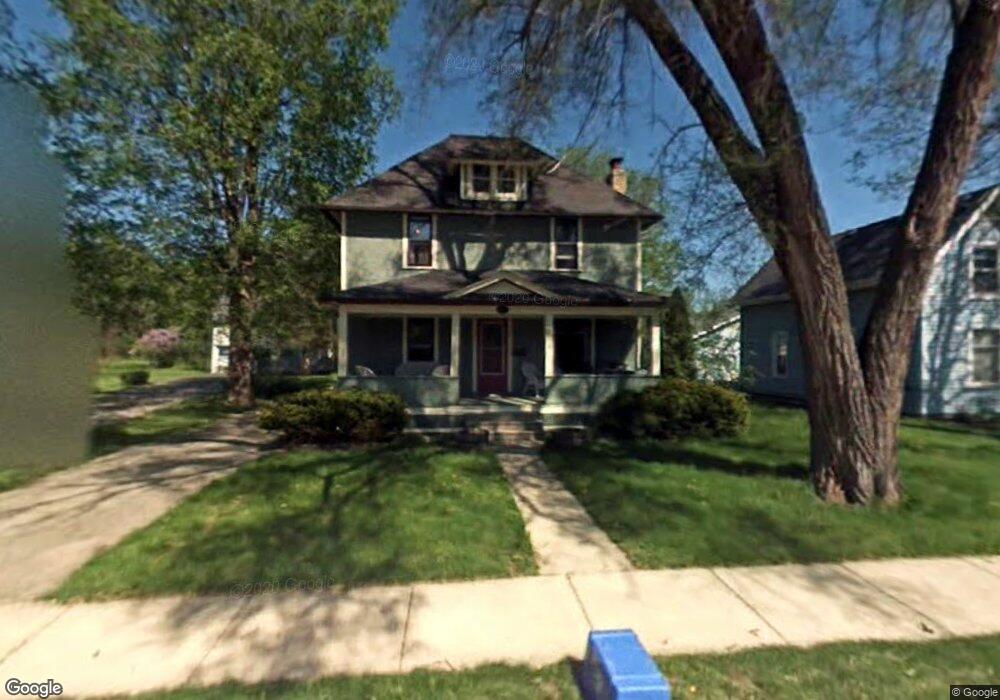
222 Maple Ave Hartland, WI 53029
Estimated Value: $401,000 - $436,000
3
Beds
1
Bath
1,814
Sq Ft
$231/Sq Ft
Est. Value
About This Home
This home is located at 222 Maple Ave, Hartland, WI 53029 and is currently estimated at $419,516, approximately $231 per square foot. 222 Maple Ave is a home located in Waukesha County with nearby schools including Arrowhead High School, St Charles Parish School, and Zion Lutheran School.
Ownership History
Date
Name
Owned For
Owner Type
Purchase Details
Closed on
May 21, 1998
Sold by
Plummer Charles W and Mattson Karla E
Bought by
Stickelmaier Terence W and Stickelmaier Ana M
Current Estimated Value
Home Financials for this Owner
Home Financials are based on the most recent Mortgage that was taken out on this home.
Original Mortgage
$160,140
Interest Rate
7.18%
Mortgage Type
VA
Create a Home Valuation Report for This Property
The Home Valuation Report is an in-depth analysis detailing your home's value as well as a comparison with similar homes in the area
Home Values in the Area
Average Home Value in this Area
Purchase History
| Date | Buyer | Sale Price | Title Company |
|---|---|---|---|
| Stickelmaier Terence W | $165,000 | -- |
Source: Public Records
Mortgage History
| Date | Status | Borrower | Loan Amount |
|---|---|---|---|
| Previous Owner | Stickelmaier Terence W | $160,140 |
Source: Public Records
Tax History Compared to Growth
Tax History
| Year | Tax Paid | Tax Assessment Tax Assessment Total Assessment is a certain percentage of the fair market value that is determined by local assessors to be the total taxable value of land and additions on the property. | Land | Improvement |
|---|---|---|---|---|
| 2024 | $3,614 | $352,100 | $72,000 | $280,100 |
| 2023 | $3,390 | $352,100 | $72,000 | $280,100 |
| 2022 | $2,975 | $245,400 | $60,500 | $184,900 |
| 2021 | $3,030 | $245,400 | $60,500 | $184,900 |
| 2020 | $3,360 | $245,400 | $60,500 | $184,900 |
| 2019 | $3,069 | $245,400 | $60,500 | $184,900 |
| 2018 | $3,161 | $219,900 | $60,600 | $159,300 |
| 2017 | $3,313 | $219,900 | $60,600 | $159,300 |
| 2016 | $3,439 | $219,900 | $60,600 | $159,300 |
| 2015 | $3,597 | $219,900 | $60,600 | $159,300 |
| 2014 | $3,571 | $219,900 | $60,600 | $159,300 |
| 2013 | $3,571 | $221,900 | $49,400 | $172,500 |
Source: Public Records
Map
Nearby Homes
- 345 Cottonwood Ave
- 459 Sunset Trail Unit 2
- 286 Hazel Ln
- 222 Granary Cir
- 447 Merton Ave
- 508 Merton Ave
- 310 Paradise Ct
- Pcl2 Hill St
- 733 Cardiff Ct
- W305N5260 Gail Ln
- 4821 Easy St Unit 8
- N53W30509 Arrowhead Dr
- 809 Crescent Ln
- 3911 Campbell Trace
- W289N4159 Farm Valley Ct
- 1117 Sweetbriar Ln Unit 22
- 1019 Wellington Way
- 1600 E Juniper Way
- W312N4890 Chapel Ridge Rd
- 1702 E Juniper Way
- 228 Maple Ave
- 229 Maple Ave Unit 231
- 210 Maple Ave
- 236 Maple Ave Unit 236A
- 216 Maple Ave
- 211 Maple Ave
- 204 Maple Ave
- 146 Maple Ave
- 203 Maple Ave Unit 205
- 302 Maple Ave
- 223 Maple Ave
- 217 Maple Ave
- 402 Park Ct
- 401 Park Ct
- 401 Park Ct Unit 401
- 235 Maple Ave
- 205 Maple Ave
- 414 Park Ct
- 140 Maple Ave
- 305 Maple Ave