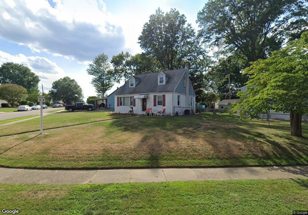
2221 Pershing Ave Morton, PA 19070
Estimated Value: $310,000 - $378,000
3
Beds
2
Baths
1,349
Sq Ft
$260/Sq Ft
Est. Value
About This Home
This home is located at 2221 Pershing Ave, Morton, PA 19070 and is currently estimated at $350,519, approximately $259 per square foot. 2221 Pershing Ave is a home located in Delaware County with nearby schools including Amosland El School, Ridley Middle School, and Ridley High School.
Ownership History
Date
Name
Owned For
Owner Type
Purchase Details
Closed on
Jun 15, 1995
Sold by
Minnis William A and Minnis Karen I
Bought by
Gaynor Marie J and Crooks Richard P
Current Estimated Value
Home Financials for this Owner
Home Financials are based on the most recent Mortgage that was taken out on this home.
Original Mortgage
$114,750
Interest Rate
8.24%
Mortgage Type
Purchase Money Mortgage
Create a Home Valuation Report for This Property
The Home Valuation Report is an in-depth analysis detailing your home's value as well as a comparison with similar homes in the area
Home Values in the Area
Average Home Value in this Area
Purchase History
| Date | Buyer | Sale Price | Title Company |
|---|---|---|---|
| Gaynor Marie J | $127,500 | Commonwealth Land Title Ins |
Source: Public Records
Mortgage History
| Date | Status | Borrower | Loan Amount |
|---|---|---|---|
| Previous Owner | Gaynor Marie J | $114,750 |
Source: Public Records
Tax History Compared to Growth
Tax History
| Year | Tax Paid | Tax Assessment Tax Assessment Total Assessment is a certain percentage of the fair market value that is determined by local assessors to be the total taxable value of land and additions on the property. | Land | Improvement |
|---|---|---|---|---|
| 2025 | $6,666 | $191,980 | $73,750 | $118,230 |
| 2024 | $6,666 | $191,980 | $73,750 | $118,230 |
| 2023 | $6,376 | $191,980 | $73,750 | $118,230 |
| 2022 | $6,171 | $191,980 | $73,750 | $118,230 |
| 2021 | $9,553 | $191,980 | $73,750 | $118,230 |
| 2020 | $6,468 | $114,500 | $37,560 | $76,940 |
| 2019 | $6,350 | $114,500 | $37,560 | $76,940 |
| 2018 | $6,271 | $114,500 | $0 | $0 |
| 2017 | $6,271 | $114,500 | $0 | $0 |
| 2016 | $628 | $114,500 | $0 | $0 |
| 2015 | $628 | $114,500 | $0 | $0 |
| 2014 | $628 | $114,500 | $0 | $0 |
Source: Public Records
Map
Nearby Homes
- 810 Quince Ln
- 734 Brooke Cir
- 706 Brooke Ave
- 2335 Poe Rd
- 668 Hutchinson Terrace
- 2329 Armstrong Ave
- 1919 Pershing Ave
- 2379 Mole Rd
- 860 Wyndom Terrace
- 601 Country Ln
- 31 Faraday Ct
- 1905 Shasta Cir
- 1908 Franklin Ave
- 1806 Unity Terrace
- 31 Silver Lake Terrace Unit 32
- 2502 Grand Ave
- 50 Silver Lake Terrace
- 425 Hutchinson Terrace
- 624 Country Ln
- 2815 Quaint St
- 819 Brooke Ave
- 2219 Pershing Ave
- 2217 Pershing Ave
- 2220 Pershing Ave
- 816 Brooke Ave
- 825 Brooke Ave
- 2222 Pershing Ave
- 2215 Pershing Ave
- 818 Brooke Ave
- 2218 Pershing Ave
- 2224 Pershing Ave
- 820 Brooke Ave
- 818 Rose Ave
- 2216 Pershing Ave
- 827 Brooke Ave
- 2223 Pershing Ave
- 2226 Pershing Ave
- 2213 Pershing Ave
- 2214 Pershing Ave
- 828 Brooke Ave