
Seller's Agent in 2026
Robin Squires
London Properties, Ltd.
(559) 284-3210
32 Total Sales

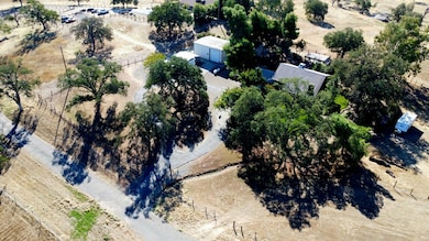
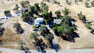
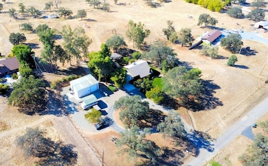
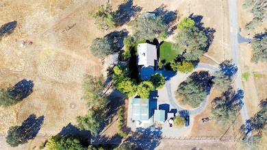
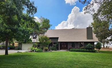
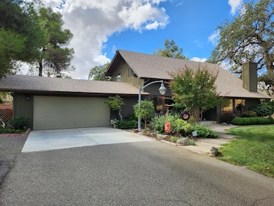
Located on approx. 4.7 acres, this property is country living at it finest. Lush landscaping, equestrian trails, open pastures & amazing views are just some of the features this property holds. Beautifully updated, this 2 story home is truly inviting. Double door entry opens into spacious living room with pellet stove & upstairs landing. 3 bedrooms plus an additional room is perfect for a 4th bedroom or office. Note, 1 bedroom & bath is downstairs allowing privacy for those over night guests. Upstairs bedrooms, master included, features balcony access with incredible views. Kitchen is spacious with granite countertops, stainless steel appliances, gas cooktop, farm sink, pantry & open to eating area. Windows throughout offer views of the grounds. Multiple outside sitting areas make entertaining a delight. Additional features include large 30x40x16 shop with car lift, 2 roll up doors & pedestrian door with combo lock, approx. 2,500 gal water tank, Generax Generator 24kw that will run the property, Smart App MyQ controls auto open & close garage door & Smart App Sensi for thermostat control. Roof is approx. 7 years old. HOAs covers private road and equestrian trails.
Last Agent to Sell the Property
London Properties, Ltd. License #01183191 Listed on: 10/03/2025
| Date | Type | Sale Price | Title Company |
|---|---|---|---|
| Grant Deed | $699,000 | Chicago Title | |
| Interfamily Deed Transfer | -- | None Available | |
| Grant Deed | -- | Chicago Title Company | |
| Individual Deed | $165,000 | North American Title |
| Date | Status | Loan Amount | Loan Type |
|---|---|---|---|
| Previous Owner | $714,028 | VA | |
| Previous Owner | $146,350 | Unknown |
| Date | Event | Price | List to Sale | Price per Sq Ft |
|---|---|---|---|---|
| 01/15/2026 01/15/26 | Sold | $699,000 | 0.0% | $381 / Sq Ft |
| 11/18/2025 11/18/25 | Pending | -- | -- | -- |
| 10/03/2025 10/03/25 | For Sale | $699,000 | -- | $381 / Sq Ft |
| Year | Tax Paid | Tax Assessment Tax Assessment Total Assessment is a certain percentage of the fair market value that is determined by local assessors to be the total taxable value of land and additions on the property. | Land | Improvement |
|---|---|---|---|---|
| 2025 | $3,088 | $297,607 | $65,132 | $232,475 |
| 2023 | $2,849 | $286,052 | $62,603 | $223,449 |
| 2022 | $2,812 | $280,444 | $61,376 | $219,068 |
| 2021 | $2,728 | $274,946 | $60,173 | $214,773 |
| 2020 | $2,719 | $272,127 | $59,556 | $212,571 |
| 2019 | $2,665 | $266,792 | $58,389 | $208,403 |
| 2018 | $2,604 | $261,562 | $57,245 | $204,317 |
| 2017 | $2,559 | $256,434 | $56,123 | $200,311 |
| 2016 | $2,465 | $251,407 | $55,023 | $196,384 |
| 2015 | $2,426 | $247,632 | $54,197 | $193,435 |
| 2014 | $2,380 | $242,782 | $53,136 | $189,646 |
Seller's Agent in 2026
Robin Squires
London Properties, Ltd.
(559) 284-3210
32 Total Sales
Source: Fresno MLS
MLS Number: 638032
APN: 138-220-39
Disclaimer: Certain information contained herein is derived from information provided by parties other than Homes.com. All information provided is deemed reliable, but is not guaranteed to be accurate and should be independently verified.
![]() IDX information is provided exclusively for personal, non-commercial use, and may not be used for any purpose other than to identify prospective properties consumers may be interested in purchasing. Information is deemed reliable but not guaranteed.
IDX information is provided exclusively for personal, non-commercial use, and may not be used for any purpose other than to identify prospective properties consumers may be interested in purchasing. Information is deemed reliable but not guaranteed.
Ask me questions while you tour the home.