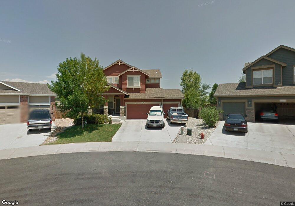
2229 Mandarin Ct Johnstown, CO 80534
Estimated Value: $569,424 - $622,000
3
Beds
3
Baths
2,461
Sq Ft
$242/Sq Ft
Est. Value
About This Home
This home is located at 2229 Mandarin Ct, Johnstown, CO 80534 and is currently estimated at $594,356, approximately $241 per square foot. 2229 Mandarin Ct is a home located in Weld County with nearby schools including Pioneer Ridge Elementary School, Milliken Middle School, and Roosevelt High School.
Ownership History
Date
Name
Owned For
Owner Type
Purchase Details
Closed on
Jan 11, 2012
Sold by
Demers Magalys C
Bought by
Demers Magalys C
Current Estimated Value
Purchase Details
Closed on
Nov 11, 2005
Sold by
The Ryland Group Inc
Bought by
Demers Magalys C and Demers Buxton E
Home Financials for this Owner
Home Financials are based on the most recent Mortgage that was taken out on this home.
Original Mortgage
$86,850
Interest Rate
5.9%
Mortgage Type
Fannie Mae Freddie Mac
Create a Home Valuation Report for This Property
The Home Valuation Report is an in-depth analysis detailing your home's value as well as a comparison with similar homes in the area
Home Values in the Area
Average Home Value in this Area
Purchase History
| Date | Buyer | Sale Price | Title Company |
|---|---|---|---|
| Demers Magalys C | -- | None Available | |
| Demers Magalys C | $296,616 | Ryland Title Company |
Source: Public Records
Mortgage History
| Date | Status | Borrower | Loan Amount |
|---|---|---|---|
| Previous Owner | Demers Magalys C | $86,850 |
Source: Public Records
Tax History Compared to Growth
Tax History
| Year | Tax Paid | Tax Assessment Tax Assessment Total Assessment is a certain percentage of the fair market value that is determined by local assessors to be the total taxable value of land and additions on the property. | Land | Improvement |
|---|---|---|---|---|
| 2025 | $2,628 | $35,310 | $9,380 | $25,930 |
| 2024 | $2,628 | $35,310 | $9,380 | $25,930 |
| 2023 | $2,468 | $37,410 | $5,750 | $31,660 |
| 2022 | $2,114 | $26,660 | $5,840 | $20,820 |
| 2021 | $3,082 | $27,430 | $6,010 | $21,420 |
| 2020 | $2,896 | $26,520 | $5,580 | $20,940 |
| 2019 | $2,265 | $26,520 | $5,580 | $20,940 |
| 2018 | $2,062 | $24,120 | $4,680 | $19,440 |
| 2017 | $2,096 | $24,120 | $4,680 | $19,440 |
| 2016 | $1,948 | $22,410 | $4,300 | $18,110 |
| 2015 | $1,975 | $22,410 | $4,300 | $18,110 |
| 2014 | $1,568 | $18,360 | $3,580 | $14,780 |
Source: Public Records
Map
Nearby Homes
- 2128 Redhead Dr
- 34 Saxony Rd
- 370 Saxony Rd
- 2507 Rouen Ln
- 230 Saxony Rd
- 139 Muscovey Ln
- 1739 Canvasback Dr
- 254 Bittern Dr
- 207 Bittern Dr
- 103 Muscovey Ln
- 2724 White Wing Rd
- 2708 Aylesbury Way
- 2726 Aylesbury Way
- 2683 Pochard Ct
- 1538 Mallard Dr
- 1519 Mallard Dr
- 9260 Meadow Farms Dr
- 944 Harvard St
- 9320 Meadow Farms Dr
- 934 Harvard St
- 2223 Mandarin Ct
- 2235 Mandarin Ct
- 2139 Redhead Dr
- 2217 Mandarin Ct
- 2133 Redhead Dr
- 2247 Mandarin Ct
- 2145 Redhead Dr
- 2271 Black Duck Ave
- 2151 Redhead Dr
- 2127 Redhead Dr
- 2263 Black Duck Ave
- 2275 Black Duck Ave
- 2212 Blue Wing Dr
- 2206 Blue Wing Dr
- 2279 Black Duck Ave
- 2259 Black Duck Ave
- 2164 Blue Wing Dr
- 2121 Redhead Dr
- 2283 Black Duck Ave
- 2268 Black Duck Ave