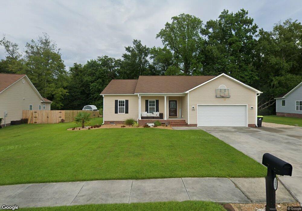
223 Channel Marker Loop Swansboro, NC 28584
Estimated Value: $314,403 - $356,000
3
Beds
2
Baths
1,616
Sq Ft
$208/Sq Ft
Est. Value
About This Home
This home is located at 223 Channel Marker Loop, Swansboro, NC 28584 and is currently estimated at $336,851, approximately $208 per square foot. 223 Channel Marker Loop is a home located in Onslow County with nearby schools including Swansboro Elementary School, Swansboro Middle School, and Swansboro High School.
Ownership History
Date
Name
Owned For
Owner Type
Purchase Details
Closed on
May 29, 2009
Sold by
Delphi Construction Inc
Bought by
Glover Kenneth and Glover Stacy
Current Estimated Value
Home Financials for this Owner
Home Financials are based on the most recent Mortgage that was taken out on this home.
Original Mortgage
$178,604
Outstanding Balance
$113,088
Interest Rate
4.81%
Mortgage Type
FHA
Estimated Equity
$223,763
Create a Home Valuation Report for This Property
The Home Valuation Report is an in-depth analysis detailing your home's value as well as a comparison with similar homes in the area
Home Values in the Area
Average Home Value in this Area
Purchase History
| Date | Buyer | Sale Price | Title Company |
|---|---|---|---|
| Glover Kenneth | $182,000 | None Available |
Source: Public Records
Mortgage History
| Date | Status | Borrower | Loan Amount |
|---|---|---|---|
| Open | Glover Kenneth | $178,604 |
Source: Public Records
Tax History
| Year | Tax Paid | Tax Assessment Tax Assessment Total Assessment is a certain percentage of the fair market value that is determined by local assessors to be the total taxable value of land and additions on the property. | Land | Improvement |
|---|---|---|---|---|
| 2025 | $2,295 | $228,327 | $45,000 | $183,327 |
| 2024 | $2,295 | $228,327 | $45,000 | $183,327 |
| 2023 | $2,295 | $228,327 | $45,000 | $183,327 |
| 2022 | $2,295 | $228,327 | $45,000 | $183,327 |
| 2021 | $1,873 | $177,500 | $36,000 | $141,500 |
| 2020 | $1,859 | $176,170 | $36,000 | $140,170 |
| 2019 | $1,859 | $176,170 | $36,000 | $140,170 |
| 2018 | $1,859 | $176,170 | $36,000 | $140,170 |
| 2017 | $1,763 | $172,030 | $38,000 | $134,030 |
| 2016 | $1,763 | $172,030 | $0 | $0 |
| 2015 | $1,763 | $172,030 | $0 | $0 |
| 2014 | $1,763 | $172,030 | $0 | $0 |
Source: Public Records
Map
Nearby Homes
- 226 Channel Marker Loop
- 604 Spoleto Ct
- 161 Howard Ln
- 274 Norris Rd
- 112 Walnut Dr
- 30 Outrigger Dr
- 4 Catalina Cir
- 1223 W Corbett Ave
- 12 Catalina Cir
- 36 Catalina Cir
- 42 Catalina Cir
- 1476 W Corbett Ave
- 84 Crush Ct
- 140 Plantation Dr
- 425 Whistling Heron Way
- 119 Tundra Trail
- 1261 Hammocks Beach Rd
- Lot 14 Hammocks Beach Rd
- 1229 Hammock Beach Rd
- 202 Nikida Ct
- 221 Channel Marker Loop
- 225 Channel Marker Loop
- 227 Channel Marker Loop
- 219 Channel Marker Loop
- 218 Channel Marker Loop
- 220 Channel Marker Loop
- 216 Channel Marker Loop
- 229 Channel Marker Loop
- 214 Channel Marker Loop
- 258 Channel Marker Loop
- 113 Borough Nest Dr
- 212 Channel Marker Loop
- 231 Channel Marker Loop
- 111 Borough Nest Dr
- 215 Channel Marker Loop
- 256 Channel Marker Loop
- 210 Channel Marker Loop
- 254 Channel Marker Loop
- 233 Channel Marker Loop
- 213 Channel Marker Loop
Your Personal Tour Guide
Ask me questions while you tour the home.