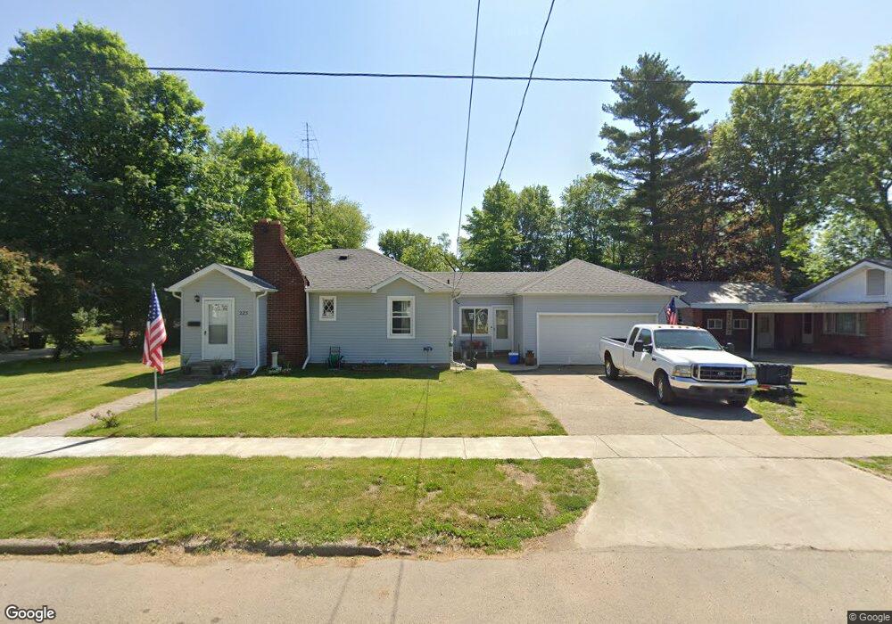
223 S Douglas St Bronson, MI 49028
Estimated Value: $142,278 - $190,000
--
Bed
--
Bath
--
Sq Ft
0.31
Acres
About This Home
This home is located at 223 S Douglas St, Bronson, MI 49028 and is currently estimated at $164,070. 223 S Douglas St is a home located in Branch County with nearby schools including Ryan Elementary School, Anderson Elementary School, and Bronson Junior/Senior High School.
Ownership History
Date
Name
Owned For
Owner Type
Purchase Details
Closed on
Dec 18, 2019
Sold by
Baird Harold R and Baird Danna Jo
Bought by
Baird Harold R and Baird Danna Jo
Current Estimated Value
Purchase Details
Closed on
Apr 23, 2010
Sold by
Raymond Sarah B and Van Hagen Courtney
Bought by
Baird Harold R and Baird Danna J
Purchase Details
Closed on
Feb 17, 2009
Sold by
Estate Of Frederick L Rosenau
Bought by
Raymond Sarah B and Van Hagen Courtney
Purchase Details
Closed on
Jul 17, 2008
Sold by
Estate Of Shirley E Rosenau
Bought by
Rosenau Frederick L
Purchase Details
Closed on
May 14, 2008
Sold by
Estate Of Reina E Robinson
Bought by
Estate Of Shirley E Rosenau
Create a Home Valuation Report for This Property
The Home Valuation Report is an in-depth analysis detailing your home's value as well as a comparison with similar homes in the area
Home Values in the Area
Average Home Value in this Area
Purchase History
| Date | Buyer | Sale Price | Title Company |
|---|---|---|---|
| Baird Harold R | -- | None Available | |
| Baird Harold R | $36,000 | Branch County Abstract & Tit | |
| Raymond Sarah B | -- | None Available | |
| Rosenau Frederick L | -- | None Available | |
| Estate Of Shirley E Rosenau | -- | None Available |
Source: Public Records
Tax History Compared to Growth
Tax History
| Year | Tax Paid | Tax Assessment Tax Assessment Total Assessment is a certain percentage of the fair market value that is determined by local assessors to be the total taxable value of land and additions on the property. | Land | Improvement |
|---|---|---|---|---|
| 2025 | $1,850 | $70,100 | $0 | $0 |
| 2024 | $814 | $68,800 | $0 | $0 |
| 2023 | $758 | $52,800 | $0 | $0 |
| 2022 | $1,700 | $44,900 | $0 | $0 |
| 2021 | -- | $41,800 | $0 | $0 |
| 2020 | -- | $36,100 | $0 | $0 |
| 2019 | -- | $32,500 | $0 | $0 |
| 2018 | -- | $29,600 | $0 | $0 |
| 2017 | -- | $29,000 | $0 | $0 |
| 2016 | -- | $29,100 | $0 | $0 |
| 2015 | -- | $26,200 | $0 | $0 |
| 2014 | -- | $24,400 | $0 | $0 |
| 2013 | -- | $27,900 | $0 | $0 |
Source: Public Records
Map
Nearby Homes
- 151 E Corey St
- 214 E Chicago St
- 644 S Matteson St
- 410 Franklin St
- 313 N Matteson St
- 337 N Walker St
- 147 Winona St
- 150 Washington St
- 544 E Chicago St
- 325 N Lincoln St
- 609 E Railroad St
- 926 Weaver Rd
- 695 W Chicago Rd
- 688 W Chicago Rd
- V/L Prairie River Rd
- 769 Kosmerick Rd
- 130 Osborn Rd
- 1009 W Chicago Rd
- 1052 Carpenter Rd
- 406 Taggart Rd
- 229 S Douglas St
- 217 S Douglas St
- 212 S Douglas St
- 230 S Douglas St
- 205 S Douglas St
- 220 S Douglas St
- 204 S Douglas St
- 235 Compton St
- 227 Compton St
- 145 S Douglas St
- 325 Compton St
- 334 S Walker St
- 334 S Walker St
- 146 S Douglas St
- 303 S Douglas St
- 312 S Walker St
- 234 Compton St
- W Grant St
- 342 S Walker St
- 305 S Ruggles St