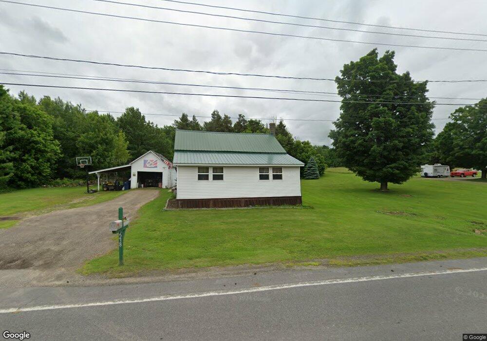
2238 State Route 11b North Bangor, NY 12966
Estimated Value: $51,000 - $123,000
3
Beds
1
Bath
1,064
Sq Ft
$84/Sq Ft
Est. Value
About This Home
This home is located at 2238 State Route 11b, North Bangor, NY 12966 and is currently estimated at $89,503, approximately $84 per square foot. 2238 State Route 11b is a home located in Franklin County with nearby schools including Brushton-Moira Elementary School and Brushton-Moira High School.
Ownership History
Date
Name
Owned For
Owner Type
Purchase Details
Closed on
Aug 30, 2012
Sold by
Martin Marie
Bought by
Martin Nicholas
Current Estimated Value
Home Financials for this Owner
Home Financials are based on the most recent Mortgage that was taken out on this home.
Original Mortgage
$25,000
Outstanding Balance
$17,291
Interest Rate
3.56%
Mortgage Type
Unknown
Estimated Equity
$72,212
Create a Home Valuation Report for This Property
The Home Valuation Report is an in-depth analysis detailing your home's value as well as a comparison with similar homes in the area
Home Values in the Area
Average Home Value in this Area
Purchase History
| Date | Buyer | Sale Price | Title Company |
|---|---|---|---|
| Martin Nicholas | $30,000 | -- | |
| Martin Nicholas | $30,000 | -- |
Source: Public Records
Mortgage History
| Date | Status | Borrower | Loan Amount |
|---|---|---|---|
| Open | Martin Nicholas | $25,000 | |
| Closed | Martin Nicholas | $25,000 |
Source: Public Records
Tax History Compared to Growth
Tax History
| Year | Tax Paid | Tax Assessment Tax Assessment Total Assessment is a certain percentage of the fair market value that is determined by local assessors to be the total taxable value of land and additions on the property. | Land | Improvement |
|---|---|---|---|---|
| 2024 | $1,335 | $32,000 | $12,200 | $19,800 |
| 2023 | $1,117 | $32,000 | $12,200 | $19,800 |
| 2022 | $1,158 | $32,000 | $12,200 | $19,800 |
| 2021 | $1,150 | $32,000 | $12,200 | $19,800 |
| 2020 | $702 | $32,000 | $12,200 | $19,800 |
| 2019 | $640 | $32,000 | $12,200 | $19,800 |
| 2018 | $507 | $32,000 | $12,200 | $19,800 |
| 2017 | $483 | $32,000 | $12,200 | $19,800 |
| 2016 | $473 | $32,000 | $12,200 | $19,800 |
| 2015 | -- | $32,000 | $12,200 | $19,800 |
| 2014 | -- | $32,000 | $12,200 | $19,800 |
Source: Public Records
Map
Nearby Homes
- 0 Cox Rd Unit 204813
- 20 Mill St
- 87 Van Dusen Dr
- 2422 U S 11
- 1822 State Route 11
- 1107 County Rt 53
- 390 Co Rt 12
- 40 Mccarthy Rd
- 0 Wagner Rd Unit 203197
- 662 Baker Rd
- 192 Wiley Rd
- 715 S South Woods Rd Rd
- 725 S Woods Rd
- 1434 County Route 22
- 1336 State Route 11b
- 752 S Woods Rd
- 601 Limekiln Rd
- 1482 U S 11
- 0 Limekiln Rd
- 2945 State Route 11
- 3 Taylor Rd
- 2228 State Route 11b
- 2245 State Route 11b
- 2225 State Route 11b
- 2231 State Route 11b
- 7 Taylor Rd
- 11 Taylor Rd
- 2258 State Route 11b
- 2257 State Route 11b
- 2207 State Route 11b
- 2267 State Route 11b
- 36 Taylor Rd
- 2192 State Route 11b
- 39 Taylor Rd
- 2279 State Route 11b
- 2280 State Route 11b
- 2189 State Route 11b
- 2287 State Route 11b
- 46 Taylor Rd
- 2290 State Route 11b