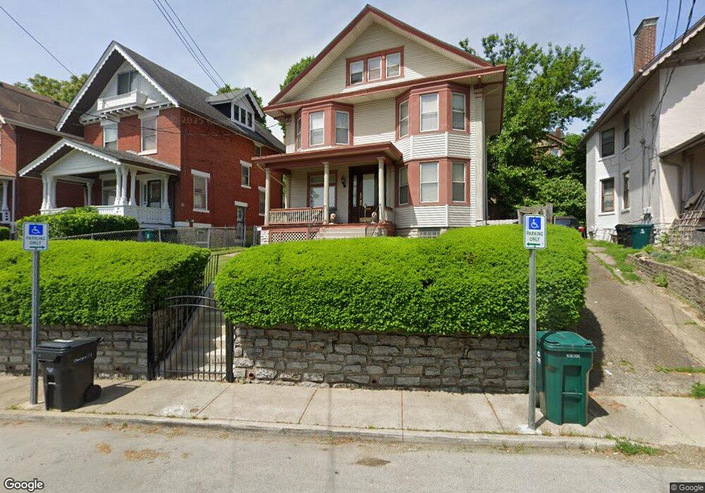
2239 Mcgregor Place Cincinnati, OH 45219
Mount Auburn NeighborhoodEstimated Value: $224,274 - $234,000
4
Beds
3
Baths
1,665
Sq Ft
$137/Sq Ft
Est. Value
About This Home
This home is located at 2239 Mcgregor Place, Cincinnati, OH 45219 and is currently estimated at $227,569, approximately $136 per square foot. 2239 Mcgregor Place is a home located in Hamilton County with nearby schools including William H. Taft Elementary School, Robert A. Taft Information Technology High School, and Clark Montessori High School.
Ownership History
Date
Name
Owned For
Owner Type
Purchase Details
Closed on
Jul 30, 2022
Sold by
Jireh Enterprises & Investments Llc
Bought by
Lillard Steven L
Current Estimated Value
Purchase Details
Closed on
Feb 26, 2022
Sold by
Unknown
Bought by
Jireh Enterprises & Investments Llc
Purchase Details
Closed on
Sep 24, 2014
Sold by
Estate Of Jewell H Lillard
Bought by
Lillard Steven L
Purchase Details
Closed on
Apr 8, 1996
Sold by
Homesteading & Urban Redevelopment Corp
Bought by
Lillard Charles L and Lillard Jewell H
Create a Home Valuation Report for This Property
The Home Valuation Report is an in-depth analysis detailing your home's value as well as a comparison with similar homes in the area
Home Values in the Area
Average Home Value in this Area
Purchase History
| Date | Buyer | Sale Price | Title Company |
|---|---|---|---|
| Lillard Steven L | -- | -- | |
| Lillard Steven L | -- | None Listed On Document | |
| Jireh Enterprises & Investments Llc | -- | Mccroskey Jeff | |
| Lillard Steven L | -- | None Available | |
| Lillard Charles L | -- | -- |
Source: Public Records
Tax History
| Year | Tax Paid | Tax Assessment Tax Assessment Total Assessment is a certain percentage of the fair market value that is determined by local assessors to be the total taxable value of land and additions on the property. | Land | Improvement |
|---|---|---|---|---|
| 2025 | $2,326 | $37,619 | $9,531 | $28,088 |
| 2024 | $2,256 | $37,619 | $9,531 | $28,088 |
| 2023 | $2,307 | $37,619 | $9,531 | $28,088 |
| 2022 | $1,286 | $19,510 | $5,436 | $14,074 |
| 2021 | $1,286 | $19,510 | $5,436 | $14,074 |
| 2020 | $1,324 | $19,510 | $5,436 | $14,074 |
| 2019 | $1,269 | $17,112 | $4,767 | $12,345 |
| 2018 | $1,271 | $17,112 | $4,767 | $12,345 |
| 2017 | $1,207 | $17,112 | $4,767 | $12,345 |
| 2016 | $1,768 | $24,752 | $4,746 | $20,006 |
| 2015 | $1,594 | $24,752 | $4,746 | $20,006 |
| 2014 | $1,606 | $24,752 | $4,746 | $20,006 |
| 2013 | $1,570 | $23,800 | $4,564 | $19,236 |
Source: Public Records
Map
Nearby Homes
- 2231 Burnet Ave
- 316 Mcgregor Ave
- 2228 Maplewood Ave
- 2320 Maplewood Ave
- 2344 Highland Ave
- 2117 Highland Ave
- 2317 Symmes St
- 268 Mccormick Place
- 238 Helen St
- 2427 Dover St
- 1911 Auburn Ave
- 1913 Auburn Ave
- 2309 Kenton St
- 224 Dorchester Ave
- 2156 Gilbert Ave
- 1948 Bigelow St
- 1944 Bigelow St
- 1946 Bigelow St
- 1942 Bigelow St
- 1940 Bigelow St
- 2235 Mcgregor Place
- 2243 Mcgregor Place
- 2231 Mcgregor Place
- 2230 Burnet Ave
- 2232 Burnet Ave
- 2226 Burnet Ave
- 2227 Mcgregor Place
- 2236 Burnet Ave
- 2249 Mcgregor Place
- 2223 Reading Rd
- 2227 Reading Rd
- 2222 Burnet Ave
- 2219 Reading Rd
- 2238 Burnet Ave
- 2223 Mcgregor Place
- 2231 Reading Rd
- 2215 Reading Rd
- 2240 Burnet Ave
- 2218 Burnet Ave
- 2220 Mcgregor Place
Your Personal Tour Guide
Ask me questions while you tour the home.