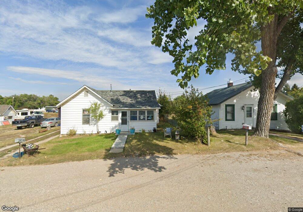
224 Bach Ave Lewistown, MT 59457
Estimated Value: $133,000 - $186,000
2
Beds
1
Bath
868
Sq Ft
$184/Sq Ft
Est. Value
About This Home
This home is located at 224 Bach Ave, Lewistown, MT 59457 and is currently estimated at $159,559, approximately $183 per square foot. 224 Bach Ave is a home located in Fergus County with nearby schools including Fergus High School.
Ownership History
Date
Name
Owned For
Owner Type
Purchase Details
Closed on
Dec 20, 2024
Sold by
Jy Investments Llc
Bought by
Donaldson Ronald W
Current Estimated Value
Home Financials for this Owner
Home Financials are based on the most recent Mortgage that was taken out on this home.
Original Mortgage
$128,709
Outstanding Balance
$127,697
Interest Rate
6.79%
Mortgage Type
VA
Estimated Equity
$31,862
Purchase Details
Closed on
Jul 8, 2009
Sold by
Rowell Bonnie S
Bought by
Jy Investments Llc
Create a Home Valuation Report for This Property
The Home Valuation Report is an in-depth analysis detailing your home's value as well as a comparison with similar homes in the area
Home Values in the Area
Average Home Value in this Area
Purchase History
| Date | Buyer | Sale Price | Title Company |
|---|---|---|---|
| Donaldson Ronald W | -- | Flying S Title And Escrow | |
| Donaldson Ronald W | -- | Flying S Title And Escrow | |
| Jy Investments Llc | -- | Realty Title Inc |
Source: Public Records
Mortgage History
| Date | Status | Borrower | Loan Amount |
|---|---|---|---|
| Open | Donaldson Ronald W | $128,709 | |
| Closed | Donaldson Ronald W | $128,709 |
Source: Public Records
Tax History Compared to Growth
Tax History
| Year | Tax Paid | Tax Assessment Tax Assessment Total Assessment is a certain percentage of the fair market value that is determined by local assessors to be the total taxable value of land and additions on the property. | Land | Improvement |
|---|---|---|---|---|
| 2025 | $1,142 | $139,500 | $0 | $0 |
| 2024 | $1,323 | $106,700 | $0 | $0 |
| 2023 | $1,329 | $106,700 | $0 | $0 |
| 2022 | $994 | $60,600 | $0 | $0 |
| 2021 | $700 | $60,600 | $0 | $0 |
| 2020 | $777 | $48,790 | $0 | $0 |
| 2019 | $772 | $48,790 | $0 | $0 |
| 2018 | $815 | $52,420 | $0 | $0 |
| 2017 | $591 | $52,420 | $0 | $0 |
| 2016 | $820 | $54,700 | $0 | $0 |
| 2015 | $608 | $54,700 | $0 | $0 |
| 2014 | $522 | $26,288 | $0 | $0 |
Source: Public Records
Map
Nearby Homes
- 414 Warr St
- NHN Truck Bypass
- TBD Truck Bypass
- 35 acres Truck Bypass
- 501 Wright St
- 1014 Mountain View Dr
- 412 W Huron St
- NHN A St
- 628 Mountain View Dr
- 632 Mountain View Dr
- 313 W Idaho St
- 316 W Corcoran St
- 105 Hillcrest Dr
- 318 W Evelyn St
- 514 2nd Ave N
- 624 W Broadway St
- 0 Tbd Unit 20682760
- 0 Tbd Unit 11290776
- 115 7th Ave N
- 1011 W Broadway St