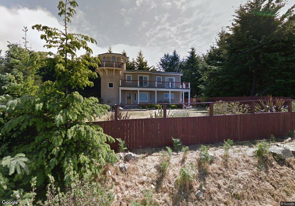
224 Parsons Rd Whitethorn, CA 95589
Estimated Value: $496,000 - $580,000
3
Beds
3
Baths
2,610
Sq Ft
$212/Sq Ft
Est. Value
About This Home
This home is located at 224 Parsons Rd, Whitethorn, CA 95589 and is currently estimated at $552,468, approximately $211 per square foot. 224 Parsons Rd is a home located in Humboldt County.
Ownership History
Date
Name
Owned For
Owner Type
Purchase Details
Closed on
Nov 29, 2018
Sold by
Tamina Isolani-Nagarvala
Bought by
Andres Aaron P and Tergis Liana N
Current Estimated Value
Home Financials for this Owner
Home Financials are based on the most recent Mortgage that was taken out on this home.
Original Mortgage
$270,000
Outstanding Balance
$236,944
Interest Rate
4.8%
Mortgage Type
New Conventional
Estimated Equity
$315,524
Purchase Details
Closed on
Jun 25, 2018
Sold by
Sage Koenig
Bought by
In Koenig Family Trust
Purchase Details
Closed on
Jan 29, 2003
Sold by
Hodge Louis
Bought by
Koenig Sage
Purchase Details
Closed on
Aug 23, 1999
Sold by
Hodge Deborah
Bought by
Hodge Louis
Create a Home Valuation Report for This Property
The Home Valuation Report is an in-depth analysis detailing your home's value as well as a comparison with similar homes in the area
Home Values in the Area
Average Home Value in this Area
Purchase History
| Date | Buyer | Sale Price | Title Company |
|---|---|---|---|
| Andres Aaron P | $350,000 | Fidelity National Title | |
| In Koenig Family Trust | -- | None Listed On Document | |
| Koenig Sage | $33,000 | Fidelity National | |
| Hodge Louis | -- | -- |
Source: Public Records
Mortgage History
| Date | Status | Borrower | Loan Amount |
|---|---|---|---|
| Open | Andres Aaron P | $270,000 |
Source: Public Records
Tax History Compared to Growth
Tax History
| Year | Tax Paid | Tax Assessment Tax Assessment Total Assessment is a certain percentage of the fair market value that is determined by local assessors to be the total taxable value of land and additions on the property. | Land | Improvement |
|---|---|---|---|---|
| 2025 | $5,303 | $474,090 | $83,661 | $390,429 |
| 2024 | $5,303 | $464,795 | $82,021 | $382,774 |
| 2023 | $5,324 | $455,682 | $80,413 | $375,269 |
| 2022 | $5,244 | $446,748 | $78,837 | $367,911 |
| 2021 | $5,052 | $437,990 | $77,292 | $360,698 |
| 2020 | $5,206 | $433,500 | $76,500 | $357,000 |
| 2019 | $5,083 | $425,000 | $75,000 | $350,000 |
| 2018 | $6,203 | $526,846 | $41,998 | $484,848 |
| 2017 | $5,865 | $516,517 | $41,175 | $475,342 |
| 2016 | $5,831 | $506,390 | $40,368 | $466,022 |
| 2015 | $5,801 | $498,784 | $39,762 | $459,022 |
| 2014 | $5,458 | $489,015 | $38,984 | $450,031 |
Source: Public Records
Map
Nearby Homes
- 450 Hillside Dr
- 1085 Hillside Dr
- 261 Parsons Rd
- 2715 Toth Rd
- 7431 Shelter Cove Rd
- 62 Highview Cir
- 65 Carson Ct
- 1071 Hillside Dr
- 175 Hillside Dr
- 86 & 112 Rawhide Ct
- 41 W Cove Point
- 8936 Shelter Cove Rd
- 268 Oak Dr
- 141 Cove Point W
- 755 Telegraph Creek Rd
- 127 Cook Rd
- 356 Nob Hill Rd
- 171 Cook Rd
- 432 Knob Hill Dr
- 36 & 56 Willow Glen Rd